Virtual urban simulation for smarter planning outcomes

Static maps and hand-drawn masterplans have defined urban planning for generations. Yet cities are not static. They breathe, shift, and respond to thousands of interacting forces simultaneously. Virtual urban simulation changes the equation entirely, giving planners and developers a dynamic lens through which to test interventions before a single foundation is poured. This guide covers what virtual urban simulation is, which methodologies drive it, what measurable outcomes it delivers, and how to integrate it responsibly into your planning workflow without falling into the trap of over-reliance.
Key Takeaways
| Point | Details |
|---|---|
| Simulation offers foresight | Virtual urban simulation predicts and tests interventions, helping to inform better urban planning decisions. |
| Multiple tools for different needs | Technologies like ABM, CFD, and digital twins each address specific urban challenges, from crowd flow to environmental monitoring. |
| Balance technology with judgement | Simulations are powerful but must be paired with expert insight, local data, and stakeholder involvement to avoid costly mistakes. |
| Quantifiable project improvements | Simulation tools have been proven to reduce emissions, costs, and delays when data and assumptions are sound. |
| Understand limitations | No model can perfectly capture human behaviour or unexpected events, so ongoing critical review is essential. |
What is virtual urban simulation?
Virtual urban simulation is more than a visualisation tool. It is a computational engine for understanding how cities behave under different conditions, pressures, and policy choices. At its core, it refers to dynamic computational models that predict behaviours, test interventions, and quantify trade-offs across complex urban systems.
Unlike static 3D models that simply display a future state, simulations run scenarios forward in time. They answer questions like: “What happens to pedestrian flow if we remove this road?” or “How does adding 500 residential units affect CO2 emissions in this district?” These are questions that two-dimensional zoning maps simply cannot answer.
The primary methodologies used in urban planning simulations today include:
- Agent-based modelling (ABM): Simulates the behaviour of individual actors such as pedestrians, vehicles, or residents, and observes how their collective behaviour shapes urban patterns.
- Computational fluid dynamics (CFD): Models airflow, wind pressure, and pollutant dispersal around building forms and street configurations.
- 4D BIM: Extends standard building information modelling into the time dimension, capturing construction sequencing and project phasing.
- Digital twins: Living simulation environments that mirror real urban systems in real time, updated continuously with sensor and data feeds.
- System dynamics: Examines feedback loops between variables like population growth, housing supply, and transport infrastructure.
- FLUS (Future Land Use Simulation): A cellular automaton model that predicts how land use will change over time based on probabilistic transition rules.
“The fundamental goal of virtual urban simulation is not to predict the future with certainty, but to reveal the range of possible outcomes and the conditions that produce them.”
This distinction matters enormously. Simulation is a structured form of informed uncertainty management. It replaces guesswork with evidence, not with false certainty.
Core technologies and methodologies
Once you understand what virtual urban simulation is, the next step is recognising which tool fits which problem. Each methodology has a specific strength, and selecting the right one for the right question is itself a professional skill.
| Methodology | Primary application | Typical output |
|---|---|---|
| Agent-based modelling (ABM) | Pedestrian flows, evacuation planning, emissions | Density heatmaps, route patterns |
| Computational fluid dynamics (CFD) | Wind comfort, ventilation, pollution | Airflow vectors, pressure maps |
| 4D BIM | Construction sequencing, phasing | Timeline visualisations, clash reports |
| Digital twins | Live urban monitoring, asset management | Real-time dashboards, anomaly alerts |
| System dynamics | Policy feedback, infrastructure demand | Stock and flow diagrams, scenario graphs |
| FLUS / Cellular automata | Land use change prediction | Future land use maps, transition probabilities |
As empirical evidence shows, ABM simulates individual behaviours for pedestrian flows and evacuations, CFD models airflow and pollutants for wind comfort, 4D BIM handles construction sequencing, digital twins provide live replicas for monitoring, system dynamics analyses feedback loops, and FLUS predicts land-use changes. Each methodology addresses a distinct category of problem, and experienced teams often combine several within a single project.
Consider a mixed-use waterfront development. ABM might test how weekend pedestrian volumes interact with cycling lanes and market stalls. CFD would validate that the tower spacing does not create dangerous wind tunnels at street level. 4D simulation in urban planning would then sequence the construction phasing to minimise disruption to adjacent businesses. Meanwhile, a digital twins in city planning framework would monitor the completed development in real time, tracking footfall, energy consumption, and air quality against projected benchmarks.
Pro Tip: Before selecting a methodology, define your decision question precisely. A simulation built around the wrong question wastes time and budget. Write the question you need to answer first, then choose the tool.
Benefits and measurable impacts of simulation
The case for virtual urban simulation is not philosophical. It is practical and increasingly quantified. Empirical benchmarks show that simulations reduce car usage, CO2 emissions, decision time, and costs. Microsimulation prevents congestion, validated CFD improves wind comfort outcomes, and ABM models reduce emissions by identifying high-impact intervention points.
The headline benefits for planners and developers are:
- Faster decision-making: Scenario testing that would take weeks of committee debate can be modelled and compared in hours, accelerating the planning process significantly.
- Reduced rework costs: Identifying design conflicts and performance shortfalls in the virtual environment rather than during construction saves substantial financial resources.
- Stronger stakeholder communication: Animated, scenario-based outputs are far more persuasive in planning hearings and public consultations than static drawings or written reports.
- Improved sustainability outcomes: Simulating energy use, mobility patterns, and land use transitions allows planners to optimise for carbon reduction before schemes are approved.
- Risk quantification: Instead of qualitative risk registers, simulation produces probability-weighted outcome ranges that make risk tangible and manageable.
- Regulatory confidence: Demonstrating compliance through validated simulations strengthens planning applications and reduces the likelihood of objections.
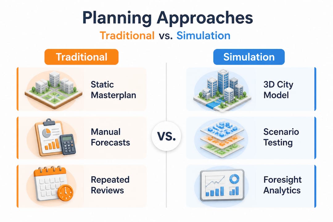
| Traditional planning approach | Simulation-enhanced approach |
|---|---|
| Static masterplan review | Dynamic scenario comparison |
| Qualitative risk assessment | Probability-weighted outcome ranges |
| Post-construction monitoring | Real-time digital twin monitoring |
| Sequential stakeholder review | Parallel collaborative scenario testing |
| Reactive design amendments | Proactive performance optimisation |
When enhancing city planning with simulation, even moderate improvements compound. A project that reduces design iteration time by 20% and prevents one major rework event can recover the entire cost of simulation tooling within a single scheme. At city scale, the returns grow proportionally.
One particularly striking result comes from transport microsimulation. When planners model traffic signal optimisation and junction redesigns before implementation, they can prevent congestion bottlenecks that would otherwise take years of post-build adjustment to resolve. The simulation does not eliminate uncertainty. It concentrates uncertainty in the virtual space where it costs far less to resolve.
Limitations, challenges, and critical perspectives
Understanding where virtual urban simulation excels is only half the picture. Recognising its limitations is equally important, and often underemphasised in technology-driven conversations.
Research highlights several critical edge cases and limitations: data gaps, high computational costs, challenges modelling social complexity and emergent behaviours, validation issues, and the risk of false certainty. Complex urban systems contain dispersed knowledge and human unpredictability that no model fully captures.
Common pitfalls to avoid when trusting simulations include:
- Treating model outputs as ground truth. A simulation is only as reliable as its inputs and assumptions. Overconfident interpretation of results is one of the most common failures in applied urban modelling.
- Ignoring data quality. Running a sophisticated ABM on outdated or poorly sampled population data produces precise but misleading outputs.
- Underestimating computational demands. City-scale digital twin simulations can require significant cloud infrastructure. Budget and timeline underestimation is frequent.
- Excluding social and cultural factors. How communities actually use space, respond to change, and resist or adopt new infrastructure is notoriously difficult to model accurately.
- Skipping stakeholder validation. Simulations complement but do not replace human judgement. Stakeholder validation and bias checks are essential before acting on model recommendations.
- Applying city-scale models to neighbourhood-level decisions. The resolution mismatch between model scale and decision scale frequently produces misleading guidance.
Pro Tip: Build a model validation step into every simulation project. Compare your model’s predictions against at least one documented real-world scenario in a comparable context before using it to inform major decisions.
The social complexity problem deserves special attention. Urban systems are not just physical. They are social and political. A simulation that accurately models traffic flows may completely miss that a proposed road closure will be politically unacceptable to a local community, or that a new park will generate uses and informal economies its designers never anticipated.
Real-time simulation in city planning is advancing rapidly, but even the most sophisticated digital twin cannot model what it has not been designed to observe. This is not a failure of technology. It is a structural characteristic of complex adaptive systems.
Integrating simulation into urban planning workflows
Acknowledging limitations does not diminish simulation’s value. It sharpens the conditions under which it should be used. The following framework helps practitioners apply simulations responsibly and effectively.
Step-by-step integration process:
- Define the decision question clearly. Articulate exactly what the simulation needs to inform. Vague questions produce vague models.
- Audit your data sources. Assess the quality, currency, and spatial resolution of available data before selecting a methodology. Poor data is the single biggest source of model failure.
- Choose the appropriate methodology. Match the tool to the question. Do not default to the most sophisticated option when a simpler model suffices.
- Build in stakeholder engagement. Involve community representatives, technical specialists, and decision-makers in reviewing simulation assumptions before running scenarios. This surfaces biases and improves model credibility.
- Validate against known conditions. Test the model against historical data or comparable case studies to establish its accuracy range before projecting into future scenarios.
- Communicate uncertainty explicitly. Present results as probability ranges and scenario comparisons, not single-point predictions. Uncertainty is information, not weakness.
- Iterate and update. Revisit model assumptions as real-world conditions evolve, particularly for projects using digital twins over a multi-year operational period.
Prioritise validation against local data and participatory integration to mitigate biases and over-reliance. Simulation is most powerful for complicated subsystems such as traffic, wind, or construction sequencing, but requires caution when applied to full city-scale complex adaptive systems.
Recommendations for selecting and integrating tools:
- Use ABM and CFD for specific performance questions with quantifiable outputs.
- Reserve digital twins for projects where ongoing operational monitoring is funded and resourced.
- Combine simulation outputs with participatory planning processes, not as a substitute for them.
- Document all assumptions explicitly in a model register so that future teams can critique and update them.
Building an efficient 3D planning workflow around simulation requires investment in both tooling and team capability. Digital twins and workflows benefit enormously from standardised data management practices that allow simulation outputs to feed directly into project decision logs without manual transcription.
Why urban simulation must never replace human insight
There is a tempting narrative in planning technology circles: that sufficiently advanced simulation will eventually make expert judgement redundant. This view deserves a direct challenge.
Contrasting viewpoints reveal a significant divide. Technical sources emphasise efficiency gains and scenario testing capabilities. Philosophical and social science critiques highlight structural limits in complex systems due to emergence and dispersed knowledge. Both perspectives are right. They simply describe different aspects of the same reality.
Simulations are extraordinarily good at structured problems. They are poor at the political, cultural, and social dimensions that ultimately determine whether urban projects succeed or fail. A CFD model will tell you exactly where wind accelerates around a building corner. It will not tell you that local residents have deep emotional ties to the street that corner anchors, ties that will shape their response to any proposed change in ways no dataset captures.
The planners and developers who extract the most value from simulation are not those who trust it most. They are those who use it strategically, as a rigorous analytical layer within a broader collaborative process. The simulation provides structured evidence. Human insight, local knowledge, and participatory engagement provide context, legitimacy, and the judgement that turns evidence into good decisions.
Explore how digital twins and city impact evolve when practitioners treat them as collaborative tools rather than oracular systems. The results are consistently better: higher stakeholder trust, more nuanced designs, and projects that hold up better under the pressures of real-world implementation.
Simulation must remain a tool in service of human planning, not a replacement for it. The cities that will benefit most from these technologies are those where planners remain firmly in the analytical driving seat.
Explore virtual urban simulation with advanced tools
Virtual urban simulation is no longer a specialist research activity. It is rapidly becoming a standard component of professional urban planning and development practice. The concepts covered in this guide, from ABM and CFD to digital twins and FLUS, are now accessible through professional-grade platforms designed for practitioners, not just researchers.
3D Cityplanner solutions bring many of these simulation capabilities into a single, accessible environment designed specifically for urban planners, architects, and real estate developers. From automatic building generation and sightline visualisations to sound disturbance simulations and 4D planning timelines, the platform makes it practical to test, visualise, and communicate urban interventions with the rigour this guide describes. A free trial period is available, so you can explore the platform’s capabilities on a real project before committing.
Frequently asked questions
How accurate are virtual urban simulations in predicting real urban outcomes?
Virtual urban simulations provide robust scenario testing, but their accuracy is constrained by data quality and social complexity. They are best treated as structured probability tools rather than precise forecasts.
What are the main types of simulation used in urban planning?
The principal methodologies are agent-based modelling, CFD, 4D BIM, digital twins, system dynamics, and cellular automata models such as FLUS, each addressing distinct planning challenges.
Can virtual urban simulations reduce project costs and delays?
Yes. Simulations reduce costs and decision time by identifying design conflicts, congestion risks, and performance shortfalls early, before expensive physical construction begins.
What are the biggest pitfalls when adopting urban simulation tools?
The most critical pitfalls are relying on poor data, ignoring social dynamics, and treating simulation outputs as definitive. Simulations complement human judgement rather than replacing it, and stakeholder validation remains essential.