Urban infrastructure modelling: techniques, tools, and impact

Urban infrastructure modelling has moved far beyond colourful 3D visualisations. When Singapore built its Virtual Singapore digital twin, the project reduced mapping costs by over 83% and cut delivery time by two-thirds. Those figures stop most planners in their tracks. This article breaks down exactly what urban infrastructure modelling is, which methodologies and tools drive real-world results, how digital twins extend modelling into live simulation, and where common projects go wrong. Whether you are managing a transport corridor upgrade or a large-scale regeneration scheme, the guidance here will help you make sharper, faster, and better-evidenced decisions.
Key Takeaways
| Point | Details |
|---|---|
| 3D modelling powers better decisions | Switching from 2D to advanced 3D infrastructure modelling unlocks significant cost and time savings for urban projects. |
| Choose proven methods and standards | Using tools like CityEngine and CityGML ensures models are accurate, scalable, and interoperable across disciplines. |
| Digital twins add real-time insight | Digital twins transform static models into predictive, interactive assets that support smarter city planning. |
| Plan for detail and benchmarks | Matching Level of Detail to project needs and validating against trusted benchmarks yields reliable, actionable models. |
What is urban infrastructure modelling?
Urban infrastructure modelling is the practice of constructing data-rich, three-dimensional representations of a city’s physical and functional systems. It goes well beyond importing a building outline into a GIS platform. A proper model integrates multiple data layers simultaneously: utility networks running beneath streets, surface transport corridors, stormwater drainage systems, green infrastructure, and building geometry at varying scales. The result is not merely a picture of the city but an analytical environment where planners can test interventions, measure impacts, and share findings with stakeholders across disciplines.
The shift from 2D to 3D is consequential. Two-dimensional maps show position but not height, volume, shadowing, or subsurface conflict. A 3D model surfaces those hidden dimensions immediately. When you add a fourth dimension, namely time, you move into 4D planning, where phasing, construction sequencing, and long-term change can all be simulated. Urban infrastructure modelling leverages this precision to avoid costly inefficiencies and support the complexity that modern city systems demand.
The practical scope of the discipline is broad. Common applications include:
- Urban renewal and regeneration: Modelling existing built fabric to identify density opportunities, heritage constraints, and infrastructure capacity before committing to design.
- Transport planning: Simulating new transit lines, road widening, and pedestrian networks against real traffic and land-use data.
- Climate adaptation: Mapping flood risk, urban heat islands, and wind corridors to inform resilient design responses.
- Real estate development: Generating massing studies, overshadowing analyses, and view impact assessments for planning applications.
- Utility coordination: Aligning underground assets to prevent clashes during construction and reduce costly redesigns.
“The greatest value of 3D urban modelling is not the model itself but the shared understanding it creates between engineers, planners, developers, and communities.” This is why building a digital twin city has become a strategic priority for municipalities worldwide.
Understanding these applications helps you scope your project correctly from day one, which is where most teams save or lose time and budget.
Key methodologies and technologies
Knowing what urban infrastructure modelling can do is one thing. Knowing how to build a robust model is another. Three broad methodological approaches dominate professional practice, each with distinct trade-offs.
| Approach | Description | Best suited for | Typical tools |
|---|---|---|---|
| Procedural generation | Rules-based automation creates buildings and urban fabric from parameters | Large-scale city models, rapid scenario testing | ArcGIS CityEngine, CGA rules |
| Hybrid workflow | Combines automated generation with manual correction and real survey data | Heritage areas, complex urban morphologies | LiDAR + photogrammetry + manual editing |
| Manual/BIM-led | Individually modelled assets derived from architectural drawings | High-detail individual buildings or precincts | Revit, ArchiCAD, CityGML export |
Leading methodologies include procedural generation via CGA scripting in ArcGIS CityEngine, LiDAR and photogrammetry-based data capture, Level of Detail 2 and 3 symmetry-aware reconstruction, and integration through CityGML 3.0. Each approach carries its own cost profile and accuracy ceiling, so matching the method to the project objective is critical.
LiDAR deserves specific mention. Airborne or mobile LiDAR surveys can capture an entire city block in hours, producing dense point clouds that fuel both building reconstruction and ground-level infrastructure mapping. Photogrammetry, using drone or street-level photography processed through structure-from-motion algorithms, complements LiDAR well in areas where point cloud gaps appear, for example under tree canopies or against highly reflective glass facades.
Once raw data is captured, integration matters. CityGML 3.0 acts as a semantic hub, letting you attach attributes such as energy performance ratings, flood vulnerability scores, or ownership data directly to building objects. This semantic richness is what separates an infrastructure model from a simple 3D render. You can learn more about the practical steps involved in creating 3D city models for planning-grade applications.
Pro Tip: Start with open standards like CityGML and build your data hub on a scalable, standards-compliant platform before investing in proprietary visualisation tools. This protects interoperability and future-proofs your model when software contracts change.
Levels of detail and standards: balancing realism and performance
One of the most consequential decisions in any modelling project is how much detail to include. More detail costs more to produce, demands more computing power to render, and takes longer to update. Too little detail, and the model cannot support the analyses you need. The concept of Level of Detail, or LoD, provides a formal framework for this choice.
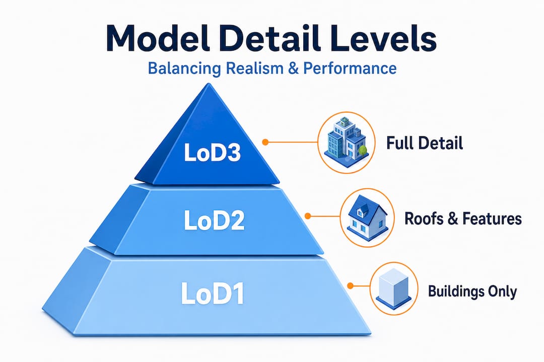
| LoD level | What it includes | Typical use case |
|---|---|---|
| LoD1 | Building footprint extruded to block height | City-wide energy estimates, population modelling |
| LoD2 | Roof form differentiated, no facade detail | Solar potential, wind studies, general massing |
| LoD3 | Textured facades, window openings, balconies | Streetscape visualisation, planning applications |
| LoD4 | Interior spaces modelled | Emergency response, building management |
LoD progression from LoD1 footprints to LoD3 textured facades directly balances compute cost against analysis depth. A city-wide solar study typically needs only LoD2, while a planning application for a sensitive heritage setting may require full LoD3 treatment.
Selecting the right LoD is not guesswork. Follow these steps to make an evidence-based decision:
- Define your analysis objectives first. List every simulation or analysis the model must support before opening any modelling software.
- Map your data sources. Identify what is available (aerial LiDAR, cadastral data, existing BIM files) and what gaps exist. Gaps often force a lower LoD than originally desired.
- Assess stakeholder needs. Decision-makers and the public often need high-fidelity visuals even when technical analysis only requires LoD2. Budget for this separately.
- Check interoperability requirements. If the model must exchange data with other platforms, confirm which LoD level those platforms support.
- Plan for update cycles. Higher LoD models are costlier to update. If your model must reflect construction changes quarterly, a lower LoD maintained accurately will outperform a neglected high-detail model.
Standards matter beyond LoD alone. CityGML Application Domain Extensions, or ADEs, extend the base schema to cover utilities, transport networks, and noise mapping. These extensions allow a single model to serve multiple technical disciplines without duplicating geometry. If you are working through the process for the first time, the modelling detail tutorial offers structured guidance on applying these concepts in practice.
Digital twins and advanced simulation
A detailed 3D model is a powerful asset. A digital twin takes that asset further by connecting it to live data streams, enabling real-time scenario testing and predictive simulation. Think of it as upgrading from a photograph to a living simulation environment that updates as the city changes.
Digital twins fuse multi-source data for real-time simulations in traffic management, flood risk assessment, and energy performance modelling, supported by GPU-accelerated rendering and rich semantic data layers. The practical applications are wide-ranging:
- Traffic and mobility: Simulating the impact of a new bus rapid transit corridor on surrounding road networks before a single metre of tarmac is laid.
- Flood and drainage: Running probabilistic flood models against changing rainfall scenarios to identify at-risk districts and test infrastructure interventions.
- Energy and carbon: Mapping building-level energy demand across entire neighbourhoods to prioritise retrofit investment.
- Construction phasing: Overlaying 4D timelines onto the model so that all project stakeholders see exactly what is being built, demolished, or closed at each stage.
- Noise and air quality: Propagating traffic noise or emissions data across the modelled terrain to assess residential impact.
The performance benchmarks for digital twin simulations are impressive. Traffic simulations using digital twin platforms can maintain 60 frames per second with 1,500 simulated vehicles, while the same project data underpinning Singapore’s Virtual Singapore saved over SGD $25 million in mapping costs and reduced delivery time by 67%. These are not theoretical projections. They are audited outcomes from a real government programme, and they illustrate precisely why the investment in building a proper digital twin urban planning environment pays back quickly.
For a deeper look at how other cities have approached this, the article on digital twins in city planning offers practical case studies and implementation lessons.
Challenges, pitfalls, and future directions
Even with strong tools and clear methodologies, urban infrastructure modelling projects encounter real-world friction. Acknowledging these challenges early helps you build more resilient workflows and realistic project plans.
Common edge cases in city modelling include handling LiDAR gaps via vertical region restoration techniques, correcting over-smoothed facades through manual sketch correction, achieving 90 to 95% accuracy rates in heritage hybrid workflows, and applying fuzzy artificial neural network hybrids for complex reconstruction scenarios. Each of these requires additional skill, time, and sometimes specialist subcontractors.
Beyond technical issues, organisational pitfalls are equally damaging. The most common mistakes practitioners make include:
- Skipping LoD planning: Starting to model without agreeing on detail levels leads to inconsistent models that cannot support the analyses promised to stakeholders.
- Poor data governance: Storing model versions in fragmented file systems, with no clear ownership or update protocol, quickly renders the model outdated and unreliable.
- Ignoring open standards: Building on proprietary formats may speed up initial delivery but creates expensive lock-in and data migration costs later.
- Underestimating integration effort: Connecting a 3D model to live GIS data, sensor feeds, or BIM exports takes significant technical effort that is often excluded from initial project budgets.
- Treating the model as a deliverable, not a platform: A model handed over at project completion and never updated loses its value within months.
Future directions in the field are focused on automation and intelligence. Semantic segmentation using machine learning is accelerating point cloud classification, reducing the manual effort needed to turn raw survey data into structured LoD2 and LoD3 models. Generative design tools are beginning to propose urban layouts that satisfy multiple constraints simultaneously, from density and solar access to acoustic performance and infrastructure capacity.
Pro Tip: Use recognised accuracy benchmarks, such as RMSE under 0.15 metres for large-scale datasets, to validate your model outputs before presenting them to decision-makers or regulators. This builds credibility and surfaces data quality issues early. The article on enhancing planning with urban digital twins covers several benchmark frameworks worth reviewing.
Why most urban infrastructure models fail to deliver real-world value
Here is an uncomfortable truth that does not appear in product brochures or conference presentations. The majority of urban infrastructure models that underperform do so not because of technical shortcomings but because they were built to impress rather than to serve a daily planning function.
Teams invest in visually stunning renders at LoD3 when the actual analysis only needed LoD1. Stakeholders approve budgets for digital twin platforms before agreeing on who will update the data, who owns the governance structure, or how the model connects to existing planning workflows. The result is a beautiful, expensive model that sits on a server and gathers digital dust.
The projects that consistently deliver measurable value share a common pattern. They start with a clearly defined problem, whether that is optimising infrastructure phasing, quantifying flood risk, or accelerating planning approvals. They then build the minimum viable model that answers that problem, using open standards to keep future expansion possible. Cross-disciplinary buy-in is established before modelling begins, not after.
Data updating is equally critical and chronically undervalued. A model that accurately reflects the city as it was eighteen months ago is not a planning tool. It is a historical record. Budgeting for continuous data ingestion, whether from periodic LiDAR surveys, building permit feeds, or IoT sensor networks, is what separates a living tool from a static asset.
Assessment against quantitative benchmarks matters more than chasing the latest software release. Teams that validate against proven accuracy metrics build institutional trust in their models, which in turn drives adoption across planning teams, developers, and elected decision-makers. The lesson is consistent: invest in integration, governance, and relevance before investing in visual sophistication.
Optimise your next urban project with advanced modelling tools
Implementing these approaches is significantly more straightforward when you have access to a platform designed specifically for planning-grade urban modelling.
3D City Planner brings together automatic building generation, line-of-sight visualisation, noise simulation, and full 4D timeline support in a single environment built for urban planning professionals. You can import existing 3D models, connect to live data sources, and present phased development scenarios to stakeholders without needing specialist GIS or CAD expertise. Explore the full range of 3D City Planner features to see how the platform addresses the methodologies and standards covered in this article. If you are ready to see how advanced modelling fits into the future of urban development, a trial period is available with no upfront payment required.
Frequently asked questions
What is the difference between urban infrastructure modelling and traditional 2D mapping?
Urban infrastructure modelling builds data-rich 3D or 4D environments that support analysis, simulation, and multi-disciplinary collaboration, whereas 2D maps cause inefficiencies worth millions by omitting height, volume, and subsurface data that planners need for accurate decisions.
How accurate can 3D city models get for infrastructure projects?
Hybrid workflows for heritage sites can achieve 90 to 95% accuracy, and large-scale benchmark datasets such as TUM2TWIN reach RMSE values at or below 0.15 metres, making these models suitable for planning, regulatory, and engineering applications.
Which standards are best for managing multi-disciplinary urban data?
CityGML 3.0 integrates heterogeneous data from BIM, GIS, and point cloud sources into a single semantic framework, with Application Domain Extensions covering utilities, transport, and noise, making it the most capable open standard for complex urban projects.
Do digital twins make a measurable difference for city planning?
Singapore’s digital twin programme cut mapping costs by over 80% and reduced project delivery times by 67%, demonstrating that properly implemented digital twins generate quantifiable return on investment rather than simply adding technical complexity.
Recommended
- Urban infrastructure planning guide for advanced 3D optimisation – 3D Urban Development
- Master urban space modelling with advanced 3D tools in 2026 – 3D Urban Development
- Master urban infrastructure mapping with 3D and 4D tech – 3D Urban Development
- 3d Building Modeling Tutorial for Efficient Urban Planning – 3D Urban Development