How urban simulation models transform city planning

City planning has long operated on a costly assumption: that real-world implementation is the only true test of an urban intervention. That assumption is wrong, and it is expensive. Urban simulation models enable testing strategies in digital testbeds before real-world implementation, reducing costs and risks for urban planners and developers. For professionals who manage multi-million pound projects and navigate competing stakeholder demands, the ability to stress-test a development in a virtual environment before a single foundation is laid is not a convenience — it is a strategic advantage. This guide explains what urban simulation models are, how they work, what they can and cannot do, and how to apply them for maximum impact.
Key Takeaways
| Point | Details |
|---|---|
| Digital testbeds reduce risk | Urban simulation models let planners trial strategies virtually, limiting costly mistakes. |
| Different models, different strengths | Choose the right type—agent-based, CFD, digital twin—for your specific urban challenge. |
| Measured improvements | Simulation use leads to lower emissions, less traffic, and faster, more informed decisions. |
| Not a replacement for judgement | Simulations support, but do not substitute, expert insight or community engagement. |
| Apply best practices | Hybrid approaches, sensitivity tests, and participatory planning get the best results from your models. |
What are urban simulation models?
Urban simulation models are computational frameworks that replicate the behaviour, structure, and dynamics of cities in a digital environment. Think of them as living, interactive blueprints — not static maps, but active systems where variables interact, consequences emerge, and planners can intervene without real-world consequences.
At their core, these models draw on spatial data, transport networks, land-use records, demographic statistics, and environmental measurements. Feeding this data into a simulation engine produces outputs that range from 3D visualisations of proposed developments to real-time analyses of traffic flow, air quality, and social movement patterns. The planner or developer then manipulates inputs — adding a new road, increasing building density, rerouting a transit corridor — and observes how the system responds.
Key methodologies include agent-based modelling (ABM) for individual behaviours, CFD for airflow and pollutants, 4D BIM for construction sequencing, digital twins for real-time monitoring, system dynamics for feedback loops, and cellular automata (for example, FLUS) for land-use change. Each has a distinct focus and optimal application. Choosing the right one is as important as using it correctly.
Key types of urban simulation models
| Model type | Primary focus | Best used for |
|---|---|---|
| Agent-based modelling (ABM) | Individual and group behaviour | Pedestrian flow, evacuation planning |
| Computational Fluid Dynamics (CFD) | Airflow, heat, pollutants | Wind comfort, air quality studies |
| Digital twins | Real-time city monitoring | Infrastructure management, live updates |
| 4D BIM | Construction sequencing | Project phasing, timeline management |
| System dynamics | Feedback loops and system behaviour | Long-term policy impact, demographic shifts |
| Cellular automata | Land-use change over time | Growth modelling, zoning scenarios |
Understanding digital twins in urban planning deserves particular attention. Unlike static 3D models, a digital twin is a continuously updated replica of a real environment. It ingests live sensor data, traffic feeds, and environmental readings to mirror what is happening in the city at any given moment. Planners working with digital twin cities can run scenarios against current baseline conditions rather than historical snapshots, which significantly improves the relevance of insights.
The practical outputs from these models include:
- 3D visualisations that communicate proposals to non-technical stakeholders
- Scenario comparisons that set different futures side by side for decision-making
- Sensitivity analyses that reveal which variables most influence outcomes
- Real-time dashboards that track key performance indicators during and after implementation
“A simulation model is only as good as the question it is designed to answer. Selecting the right methodology for your specific planning challenge is the first and most critical decision in any simulation project.”
How simulation models change the game for urban projects
Now that the fundamentals are clear, the real question is whether these models make a measurable difference. The evidence says yes, consistently and across diverse project types.
Empirical benchmarks show simulations reduce car usage, CO2 emissions, and decision time, while preventing congestion and optimising land use in real projects. These are not theoretical projections — they reflect outcomes observed in cities that have committed to simulation-led planning processes. The difference between a planning team that runs scenarios in a digital environment and one that relies on static projections can be measured in months of saved time and millions in avoided costs.
Traffic modelling is one of the clearest illustrations. Benchmarking studies of microscopic traffic simulation tools show that VISSIM best matches real travel times and safe gap distances of 1 to 2 metres, while SUMO demonstrates low error in safe gap modelling at 0.0081, with strong scalability for large urban scenarios. Choosing the right traffic simulator for your project scale and data environment directly affects the reliability of your outputs.
Top use cases for urban simulation models
- Traffic and mobility planning. Simulate the impact of new junctions, modal shifts, or congestion pricing before implementation. Adjust signal timing virtually and observe system-wide effects.
- Air quality and pollution mapping. Use CFD models to track pollutant dispersion from roads, industrial areas, or planned infrastructure, identifying risk zones and informing mitigation strategies.
- Development impact assessment. Model how a new residential or commercial development changes shadow patterns, wind conditions, traffic load, and green space accessibility for surrounding neighbourhoods.
- Land-use planning and zoning. Apply cellular automata models like FLUS to forecast how zoning changes will shape urban growth over 10 to 30-year horizons, testing multiple policy scenarios simultaneously.
- Infrastructure resilience. Run stress tests on utilities, transport networks, and emergency services under scenarios like population surges, extreme weather events, or major infrastructure failure.
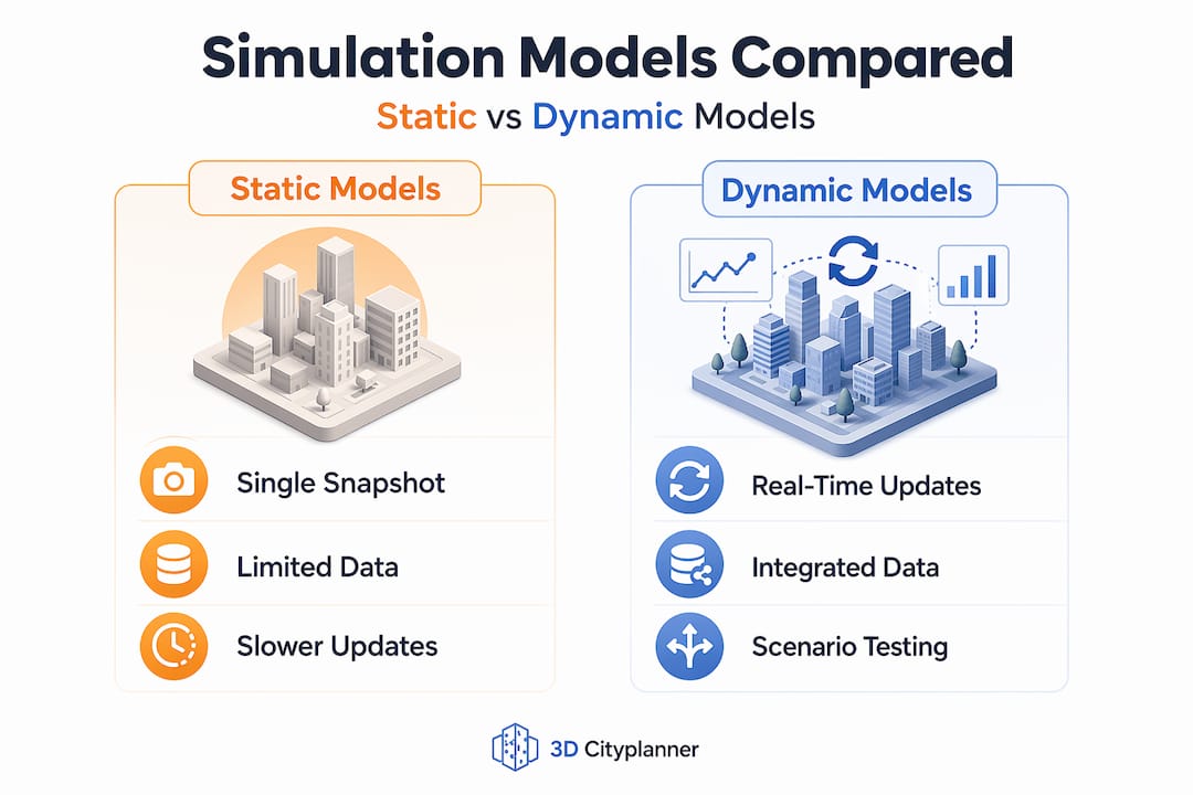
Static vs dynamic models: why the comparison matters
| Feature | Static model | Dynamic simulation |
|---|---|---|
| Data integration | Snapshot in time | Continuous or real-time updates |
| Scenario testing | Limited | Multiple concurrent scenarios |
| Stakeholder communication | Diagrams and drawings | Interactive 3D visualisations |
| Decision confidence | Lower | Significantly higher |
| Adaptability | Manual updates only | Automated recalibration |
Explore urban simulation case studies to see how leading cities have used these approaches to drive genuinely better outcomes — from Copenhagen’s cycling infrastructure planning to Singapore’s nation-scale digital twin programme.
Pro Tip: Always calibrate your simulation with empirical, locally sourced data before drawing conclusions. A model trained on generic datasets will produce generic results. Local calibration is what transforms a simulation from an illustration into a reliable planning tool.
Are there risks or limitations?
Despite their power, simulations are not a magic bullet. Understanding edge cases and critical limitations is vital for any professional who wants to use these tools responsibly rather than decoratively.
Research is clear that edge cases and limitations include data gaps, social complexity, computational costs for agent-based models, the inability to capture dispersed social knowledge in complex cities, over-reliance risks, and the assumption that past trends will continue into the future. Each of these limitations has practical consequences for real projects.
Key limitations to plan for
- Data quality and gaps. Simulation accuracy depends entirely on the quality of input data. Incomplete transport datasets, outdated land-use records, or poorly calibrated sensor networks will produce misleading outputs. Garbage in, garbage out remains the defining principle.
- Social complexity. Cities are social systems, not just physical ones. Agent-based models can simulate individual movement, but they struggle to capture the nuanced, culturally specific ways communities respond to change. Gentrification dynamics, community resistance, and informal economies are difficult to model reliably.
- Computational resource demands. City-scale ABM simulations with millions of agents require significant computing infrastructure. For smaller consultancies or under-resourced public authorities, this can be a genuine barrier to adoption.
- Emergent behaviour. Complex urban systems produce emergent behaviours that no model has been programmed to predict. A new transit line may trigger unexpected commercial clustering; a new park may shift residential demand in counterintuitive ways.
- Over-reliance and false precision. A persuasive 3D visualisation can create unwarranted confidence in a specific outcome. Decision-makers may treat simulation outputs as forecasts rather than as one input among many.
Critically, simulations augment expertise but do not substitute for it. Technical excellence is useless without stakeholder understanding, and complex systems fundamentally limit predictive power. Read more on the challenges of urban simulation to understand where tools help and where human judgement remains irreplaceable.
“Simulations are decision aids. They sharpen questions, surface trade-offs, and structure dialogue. They do not replace the political, ethical, and social judgements that only human planners can make.”
Pro Tip: Engage community stakeholders alongside your technical models, not after them. Running participatory workshops while simulations are still in development allows you to incorporate local knowledge that algorithms simply cannot capture, and it builds the social trust that determines whether a project succeeds on the ground.
Best practices for applying urban simulation models
With limitations in mind, these proven strategies help planners and developers get reliable, actionable results from urban simulation models.
Expert guidance consistently recommends matching methodology to the planning question, running sensitivity analyses and multiple scenarios, and integrating simulation with participatory planning to avoid siloed use. This is practical wisdom earned through real project experience, and it translates directly into better decisions and fewer costly surprises.
A step-by-step framework for applying simulation models effectively
- Define the planning question precisely. Before selecting any tool, write down exactly what you are trying to understand. “How will this development affect air quality?” demands CFD. “How will residents change their travel behaviour?” demands ABM. The question determines the method.
- Audit your data sources. Identify what data you have, what gaps exist, and how you will fill them. Local sensor networks, GIS layers, transport authority datasets, and building registers are all potential inputs. Quality-check everything before it enters the model.
- Select the right model type. Use the framework from the table in the previous section. For integrated land-use and transport questions, consider hybrid models. LUTI models combined with demographic and economic forecasting provide integrated forecasting for land-use and transport interactions, as demonstrated in the Turin case study, where hybrid approaches outperformed single-method simulations for long-range planning.
- Run sensitivity analyses before committing to conclusions. Vary your key assumptions — population growth rate, car ownership levels, energy price scenarios — and observe how much your outputs change. High sensitivity to a particular variable signals a need for better data or a more cautious interpretation.
- Test multiple scenarios explicitly. Do not present a single simulation output as a recommendation. Present a baseline, an optimistic scenario, and a stress scenario. This gives decision-makers a structured range to evaluate rather than a single, potentially misleading number.
- Integrate findings with participatory planning. Share simulation outputs in accessible formats — interactive 3D models, scenario comparison dashboards, and video walkthroughs work well for public engagement. Invite feedback that refines your assumptions.
- Document assumptions transparently. Every simulation rests on assumptions. Make them explicit in your reporting so that reviewers, auditors, and future planners can understand and challenge the basis for your conclusions.
Consult the guide to 3D technology in planning for a deeper look at how these tools fit into the broader planning technology ecosystem, and explore how virtual cities enhance planning when simulation is embedded in a connected digital twin environment.
Pro Tip: Blend simulation with participatory planning for the best results. The most successful projects we see are not those with the most sophisticated models — they are those where the model outputs are used to structure genuine community dialogue and collaborative decision-making.
A critical perspective on simulation: what most planners miss
Here is an uncomfortable truth that the technology industry rarely volunteers: the biggest risk with urban simulation is not technical failure. It is success without wisdom.
When a simulation produces a compelling, photorealistic 3D output showing a thriving new district, there is a powerful temptation to treat that image as a promise. Stakeholders see it, politicians approve it, and the nuance embedded in the model’s assumptions quietly disappears from the conversation. This is where simulation becomes a liability rather than an asset.
Researchers caution that despite the power of city-scale digital twins, caution is needed in complex emergent systems. A critical approach should take priority over over-optimism. This is not a critique of the technology — it is a call for professional maturity in how we use it.
The planners and developers who get the most from simulation are those who treat these tools as explorative and participatory instruments rather than prediction machines. They run simulations to surface questions, not to settle them. They share outputs as conversation starters with communities, not as final answers from an algorithm. They stay curious about what the model cannot show and actively seek that knowledge through field research and community engagement.
Transforming city planning with digital twins is genuinely possible — but the transformation is most durable when it combines technical rigour with collaborative, critical thinking. The professionals who will shape the best cities of the next decade are not those who trust their models most. They are those who know exactly when to question them.
Unlock advanced urban simulation with 3D Cityplanner
If you are ready to move beyond static plans and incorporate advanced simulation into your urban projects, the tools you need are closer than you think.
3D Cityplanner is built for exactly the professionals this guide addresses: planners and developers who need precision, speed, and the ability to communicate complex spatial insights to diverse stakeholders. The platform offers automatic building generation, line-of-sight visualisations, noise nuisance simulations, 4D planning with automatic timelines, and import capabilities for a wide range of 3D models. You can test scenarios in real time, adjust project phases, and share interactive outputs that bring stakeholders into the decision-making process. Explore the full feature list to see how each capability maps to your current challenges, or visit 3D Cityplanner for modern urban projects to start a free trial with no payment required upfront.
Frequently asked questions
What is the main benefit of using urban simulation models?
Urban simulation models allow planners to test strategies virtually before real-world implementation, reducing costly errors and significantly lowering project risk.
What are common types of urban simulation models?
Leading types include agent-based models for individual behaviour, CFD for airflow and pollutants, digital twins for real-time monitoring, 4D BIM for construction sequencing, system dynamics, and cellular automata for land-use change.
Can simulation models fully predict city development?
No. Simulations augment expertise but cannot fully capture complex human behaviour or emergent urban dynamics — they are decision aids, not oracles.
What are the risks of relying only on simulation?
The main risks include data gaps, over-reliance, missed social complexity, and the flawed assumption that historical trends will simply continue, which can embed systematic errors into future planning decisions.
How do I choose the right simulation model for my project?
Match your methodology to your core question: use CFD for wind and air quality, ABM for human behaviour, and hybrid LUTI approaches when land-use and transport interactions need integrated forecasting.