How to manage urban data: a guide for planners
Urban data management is defined as the structured process of collecting, verifying, analysing, and communicating city-level information to support planning decisions. Done well, it transforms raw inputs from IoT sensors, GIS layers, and field surveys into trusted evidence for zoning, infrastructure, and development choices. Research across 27 European cities identified 12 core governance requirements for effective urban data management, covering standardised formats, access rules, and interdepartmental collaboration. That finding signals something planners often underestimate: the technical side is only half the challenge. Governance, culture, and workflow design determine whether your data actually drives decisions.
How to manage urban data: the four-step cycle
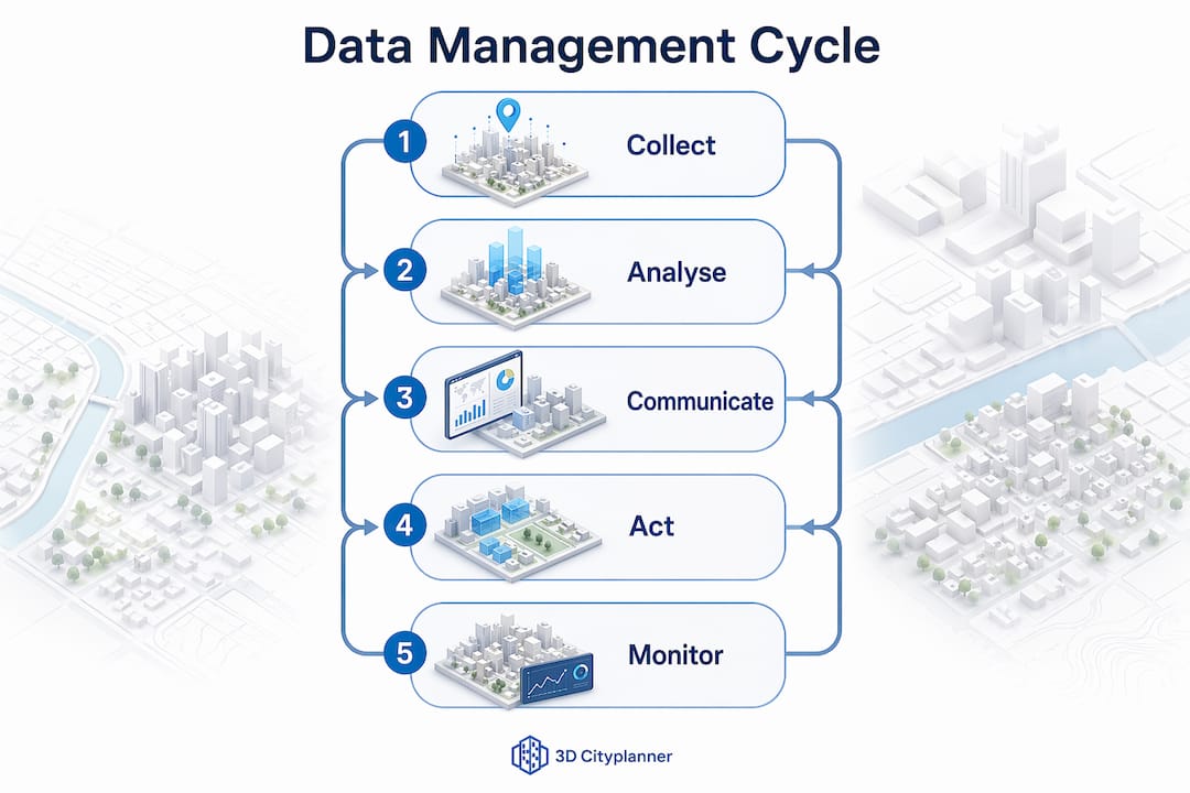
Effective urban data management follows four sequential steps: collection, analysis, communication, and action. Each step depends on the quality of the one before it, which is why skipping data cleaning between collection and analysis is the most common and costly mistake planners make.
Step 1: Collection
Data enters your system from multiple sources simultaneously. IoT sensors track pedestrian flows and air quality. GIS databases hold parcel boundaries, land use designations, and infrastructure networks. Social media and citizen reports add qualitative texture. The challenge is not volume. It is consistency. Without agreed input formats, data from different departments cannot be merged without significant rework.

Step 2: Analysis
Raw data becomes useful only after cleaning and verification. Remove duplicates, flag outliers, and cross-reference against known baselines before running any spatial analysis. Digital twins and dashboards are the most effective tools for this stage because they allow planners to test scenarios visually rather than working through static spreadsheets.
Step 3: Communication
Analysis that stays inside a GIS platform serves no one. Effective communication means translating findings into formats that non-technical stakeholders can act on. 3D visualisations, scenario comparison maps, and interactive dashboards all reduce the gap between data and decision.
Step 4: Action and monitoring
The cycle closes when decisions are implemented and their outcomes are tracked. Monitoring feeds new data back into the collection stage, creating a continuous improvement loop rather than a one-off project.
Pro Tip: Track metadata and data lineage from the start. Knowing where a dataset came from, when it was collected, and how it was processed is what separates AI-ready urban data from data that produces misleading outputs when fed into analytics models.
How to collect high-quality urban data
The shift from manual field surveys to reproducible data pipelines is the single biggest quality improvement available to planning teams. Reproducible methods like USE-SVI protocols standardise street-view image sampling by mandating multiple directional captures at consistent intervals. That removes the sampling bias that plagues ad hoc photography.
Mobile survey tools with offline capability and automated syncing, such as ODK (Open Data Kit), solve a persistent field problem: data loss when connectivity drops. Teams working in areas with poor network coverage can collect structured data offline and sync it automatically on return. The result is a complete, timestamped dataset rather than a patchwork of paper notes.
Key practices for high-quality urban data collection:
- Standardise input formats before fieldwork begins. Define field names, units, and acceptable value ranges in a shared data dictionary.
- Use participatory mapping to supplement remote sensing. Community-verified mapping improves accuracy, particularly in informal settlements where satellite imagery alone misses ground-level detail.
- Ground-truth all satellite data. Satellite imagery must be verified against field observations. The hidden time cost of ground-truthing is real and must be built into project timelines from the outset.
- Assign data ownership. Every dataset needs a named steward responsible for its accuracy and update schedule.
- Document collection conditions. Record weather, time of day, and equipment used. These variables affect data quality and matter when results are questioned later.
Pro Tip: Pilot your collection protocol on a single neighbourhood before city-wide rollout. Errors in field methodology are far cheaper to fix at small scale than after thousands of records have been gathered.
Which tools best support urban data analysis and communication?
The right platform does more than store data. It connects datasets, surfaces conflicts, and presents findings in a format that planners and elected officials can both understand. Three categories of tool matter most.
Digital twin platforms create a live, three-dimensional model of the city that updates as new data arrives. Planners use them to test building massing, sunlight access, visibility corridors, and infrastructure capacity before any physical change occurs. 3D Cityplanner operates as a browser-based digital twin platform that combines GIS data, 3D city models, and scenario planning in a single environment. It supports early-stage feasibility studies, masterplanning, and stakeholder communication without requiring specialist GIS software on every machine.
Urban data governance dashboards add a layer of oversight that pure visualisation tools lack. The Urban Data Governance Digital Twin framework, for example, includes executive control panels, data lineage maps, quality scoring modules, and AI-readiness evaluations. These features let data managers identify which datasets are reliable, which are outdated, and which need verification before use.
Integrated city visualisation platforms serve the communication function. They translate complex spatial analysis into maps, charts, and 3D renders that work in public consultations and council presentations. The role of digital twins in this context is to make abstract data tangible. A proposed development shown in 3D context, with shadow analysis and green space calculations visible, communicates far more than a planning report ever could.
The practical difference between these tool categories comes down to audience. Governance dashboards serve internal data teams. Digital twins serve planners and analysts. City visualisation platforms serve decision-makers and the public. Effective urban data management requires all three.
What governance frameworks does urban data management require?
Data governance for planners is an organisational and cultural shift, not a technical upgrade. The research is clear on this point. Planners must treat data as a critical resource and move from isolated spreadsheets to integrated, collaborative environments where stewardship roles and responsibilities are formally defined.
The urban data governance reference model, developed from research across European cities, organises governance into four foundation layers and four pillars that integrate technology, organisation, and culture. The four foundations address data standards, access rules, quality assurance, and interoperability. The four pillars cover roles and responsibilities, processes, technology infrastructure, and cultural alignment. Together they provide a structure for breaking down the data silos that prevent departments from sharing information effectively.
A phased implementation approach works better than a city-wide rollout. Phased smart data management is specifically recommended for resource-constrained environments because it builds governance capacity alongside technical capacity rather than demanding both at once.
A practical sequence for building governance:
- Audit existing data assets. Map what data your organisation holds, who owns it, and how it is currently stored and shared.
- Define stewardship roles. Assign named individuals as data stewards for each major dataset. Stewards are accountable for quality, access, and updates.
- Establish data standards. Agree on formats, naming conventions, and update frequencies across departments before integrating systems.
- Build interdepartmental workflows. Create formal processes for sharing data between planning, transport, environment, and housing teams.
- Run pilot projects. Pilot projects build trust across departments and expose governance gaps before they affect city-wide decisions.
Urban data platforms succeed only when paired with a clear data culture and defined stewardship responsibilities. Technical tools alone cannot overcome organisational resistance or unclear ownership.
How to implement urban data management and avoid common mistakes
Implementation fails most often because of three avoidable mistakes: ignoring metadata, poor interdepartmental collaboration, and attempting too much too soon. Each has a practical fix.
Ignoring metadata means datasets become orphaned. No one knows when a traffic count was collected, which sensor recorded it, or whether the methodology changed mid-survey. The fix is a metadata standard applied at the point of collection, not retrospectively.
Poor collaboration produces duplicate datasets and conflicting figures. Two departments measuring the same thing differently creates confusion in analysis and erodes trust in the data. Shared data dictionaries and regular cross-departmental data reviews prevent this.
Overambitious rollout exhausts teams and produces fragile systems. Starting with a single data domain, such as parking occupancy or green space coverage, allows teams to build competence and confidence before expanding scope.
Practical steps for effective implementation:
- Set measurable data quality targets before launch, not after.
- Schedule quarterly data audits to catch drift in quality or coverage.
- Use collaborative planning environments to keep all stakeholders working from the same dataset.
- Document every change to a dataset, including who made it and why.
- Review outcomes against planning decisions to close the monitoring loop.
Continuous monitoring is what separates a functioning data management system from a one-time project. The goal is a living system that improves with each planning cycle.
Key takeaways
Effective urban data management requires a structured four-step cycle, strong governance, reproducible collection methods, and digital tools that connect data to decisions.
| Point | Details |
|---|---|
| Follow the four-step cycle | Collect, analyse, communicate, and act on data in sequence, with quality checks at each stage. |
| Standardise collection methods | Use reproducible protocols like USE-SVI and mobile tools with offline capability to reduce errors. |
| Build governance before scaling | Define stewardship roles and data standards before integrating systems across departments. |
| Use digital twins for communication | 3D visualisation platforms translate complex data into formats that planners and stakeholders can act on. |
| Phase your implementation | Start with pilot projects to build trust and expose governance gaps before city-wide rollout. |
What I have learned about urban data management the hard way
The technology conversation in urban planning tends to run ahead of the governance conversation. Planners invest in platforms before they have agreed on who owns the data those platforms will hold. I have seen this pattern repeat across projects of very different scales, and the result is always the same: technically capable systems that nobody trusts.
The governance reference model built from research across 27 European cities is not abstract theory. Its four foundation layers map directly onto the practical failures I have observed: no agreed standards, unclear access rules, no quality assurance process, and systems that cannot talk to each other. Fixing those foundations is unglamorous work. It involves meetings, documentation, and organisational negotiation rather than software procurement. But it is the work that determines whether your data management investment pays off.
Digital twins change the equation in one important way. When planners can show a proposed development in 3D, with sunlight analysis, green space calculations, and infrastructure capacity visible in the same view, the conversation with decision-makers shifts. Data stops being something that lives in a database and becomes something that informs a visible, testable future. That shift in perception is what makes governance worth fighting for. If the data feeds a model that people can see and interrogate, they start to care about its quality.
My advice to any planning team starting this process: resist the urge to solve everything at once. Pick one data domain, build your governance around it properly, and demonstrate value before expanding. Cultural change follows demonstrated results, not ambitious plans.
— Anne Dullemond
How 3D Cityplanner supports your urban data workflow
3D Cityplanner is a browser-based digital twin for cities that brings GIS data, 3D city models, and scenario planning into a single working environment. Planners use it to design, analyse, and compare spatial development scenarios covering building massing, infrastructure, public space, greenery, sunlight, and parking capacity. The platform supports the full urban data management cycle, from early-stage feasibility analysis through to stakeholder communication and governance reporting. For teams building or refining their data management practice, 3D Cityplanner provides the city visualisation tools needed to turn verified data into decisions that hold up to scrutiny.
FAQ
What is urban data management?
Urban data management is the structured process of collecting, verifying, analysing, and communicating city-level data to support planning and development decisions. It combines technical tools, governance frameworks, and organisational practices to ensure data is accurate, accessible, and usable.
What are the main challenges in urban data handling?
The main challenges are data silos between departments, inconsistent collection methods, poor metadata practices, and the absence of clear stewardship roles. Research across 27 European cities identified these as the core barriers to effective urban data governance.
How do you collect urban data reliably?
Reliable urban data collection uses standardised, reproducible protocols such as USE-SVI for street-view imagery and mobile tools like ODK for field surveys. Ground-truthing satellite data through participatory mapping adds a further layer of verification, particularly in complex urban areas.
What role do digital twins play in urban data analysis?
Digital twins serve as live, three-dimensional environments where planners can test scenarios, visualise data outputs, and communicate findings to stakeholders. Platforms like 3D Cityplanner combine GIS data and 3D city models to support scenario comparison and early-stage feasibility analysis.
How should a planning team start building a data governance framework?
Start with a data audit to map existing assets and ownership, then define stewardship roles and agree on data standards before integrating systems. A phased approach, beginning with pilot projects in a single data domain, builds trust and exposes governance gaps before city-wide adoption.