Automated site planning: a practical guide for 2026
Automated site planning is the process of using AI-driven software and parametric modelling to generate zoning-compliant, optimised site layouts rapidly, replacing traditional manual workflows. Where a conventional feasibility study might take a team days or weeks, AI-native platforms can deliver yield estimates and compliance checks in seconds. For urban planners, architects, and real estate developers, this shift is not incremental. It fundamentally changes how early-stage decisions are made, how risk is assessed, and how quickly a project can move from concept to planning submission.
What tools and technologies enable automated site planning?
Automated site planning relies on three distinct technology categories: AI-native yield and zoning platforms, parametric settlement pipelines, and GIS-integrated compliance tools.
AI-native platforms unify land acquisition, zoning analysis, and market intelligence into a single workflow. Platforms in this category can reduce yield estimation from days or weeks to seconds, replacing engineering studies that previously cost £2,400–£7,900 per site. That speed allows developers to screen dozens of parcels before committing to a single site visit.

Parametric settlement pipelines take a different approach. Tools built on this model automate the full production of subdivision plans through 9 sequential stages, covering building massing, parking layout, and landscaping. Each stage feeds directly into the next, removing the manual handoffs that typically introduce errors and delays.
GIS-integrated compliance tools sit at the intersection of spatial data and regulatory checking. Pre-permitting platforms that draw on verified GIS and council data achieve 97% accuracy in feasibility and compliance checks. That figure matters because a single zoning error caught late in the process can cost months of redesign.
A fourth capability is increasingly central: AI parsing of zoning documents. Platforms that convert complex zoning PDFs into structured, queryable data allow planners to run instant multi-scenario comparisons without manually reading through hundreds of pages of local planning policy.
| Feature category | What it does |
|---|---|
| Yield estimation | Calculates buildable units from lot dimensions and setback rules |
| Zoning compliance checking | Flags regulatory conflicts before design progresses |
| Parametric massing | Generates building volumes across 12 architectural typologies |
| Environmental impact auditing | Screens sites against environmental constraints automatically |
| Multi-scenario comparison | Runs and compares multiple layout options simultaneously |
Pro Tip: When evaluating automated planning software, check whether it ingests live GIS data or relies on static uploads. Live data connections prevent the compliance errors that arise when parcel boundaries or zoning codes change mid-project.
How to prepare for automated site planning
Good automation produces bad results when it runs on bad data. Preparation is the stage most planners underestimate, and it is where most workflow failures originate.
- Assemble accurate GIS parcel data. Source parcel boundaries, ownership records, and topographic data from your national or local cadastral authority. Cross-reference against council mapping portals to catch discrepancies before they propagate through the model.
- Enter lot-width, lot-depth, and setback controls. These parameters govern yield calculations directly. An error of one metre in a setback value can shift a site from viable to unviable, or overstate unit counts by a material margin.
- Verify current zoning codes. Zoning documents change. Confirm you are working from the version currently in force, not a cached or downloaded copy from six months prior. National planning policy frameworks and local development plans both require checking.
- Load 3D city model context. Surrounding building heights, street widths, and public space geometry all affect massing decisions. A 3D city model gives the automation engine the spatial context it needs to generate layouts that actually fit the neighbourhood.
- Confirm data source provenance. Record where each dataset came from and when it was last updated. This audit trail supports planning submissions and protects against challenges to your feasibility assumptions.
Pro Tip: Run a test parcel through your chosen platform before committing your full dataset. A single test reveals data format mismatches, projection errors, and missing attribute fields before they affect your live project.
How does automated site planning work step by step?
The execution of a site development automation workflow follows a logical sequence. Each step builds on the last, and skipping any stage creates compounding errors downstream.
Step 1: Parcel selection and constraint input. Select the target parcel and enter its legal boundaries, zoning classification, and applicable setback and height controls. This is the foundation for everything that follows.
Step 2: AI-driven zoning compliance and yield estimation. The platform reads the constraint inputs against the applicable zoning code and calculates the maximum developable yield. This step replaces the manual engineering study and delivers results in seconds rather than days.
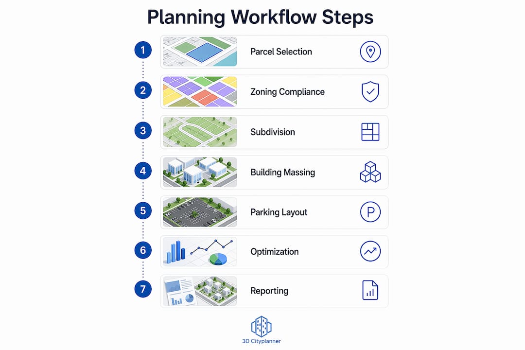
Step 3: Parcel subdivision generation. The system divides the site into individual lots or development zones according to the subdivision rules in force. Parametric pipelines typically apply one of several architectural mass typologies at this stage, selecting the form that best fits the site geometry.
Step 4: Building massing. The platform places building volumes on each subdivided parcel, respecting height limits, floor-to-area ratios, and daylight requirements. Platforms with 12 architectural mass typologies give planners meaningful design variety without manual modelling.
Step 5: Parking layout and landscaping integration. Automated parking layout calculates the number of spaces required under local standards and positions them within the site. Landscaping buffers and public open space are integrated at the same stage, ensuring the layout meets amenity requirements from the outset.
Step 6: Geometric optimisation and conflict detection. This is the quality-control stage. Tools like BuildingOptimizer apply rollback and geometry optimisation to detect and resolve conflicts, such as overlapping building footprints or access routes that breach setback lines, before the plan is finalised.
Step 7: Reporting and population projections. The platform generates a summary report covering unit counts, gross floor area, parking provision, open space ratios, and projected population. This output feeds directly into planning submissions and stakeholder presentations.
The table below maps each step to its primary output:
| Step | Primary output |
|---|---|
| Parcel selection and constraint input | Verified site brief |
| Zoning compliance and yield estimation | Buildable unit count |
| Parcel subdivision | Lot layout plan |
| Building massing | 3D massing model |
| Parking and landscaping | Compliant site layout |
| Geometric optimisation | Conflict-free final plan |
| Reporting | Planning submission package |
Common challenges in automated site planning workflows
The biggest obstacle in site layout optimisation is fragmented zoning data. Most local planning authorities still publish zoning rules as unstructured PDFs, and AI platforms cannot query what they cannot parse. The solution is to use a platform that converts these documents into structured data before running any analysis.
- Outdated parcel records. Cadastral data is often months behind actual ownership changes. Always verify parcel boundaries against the most recent council records before running yield calculations.
- Geometric conflicts in generated layouts. Automated massing can produce overlapping footprints or access conflicts when site geometry is irregular. Geometric optimisation tools with rollback capability resolve these conflicts automatically, but planners should review the output visually before submission.
- Missing setback or height data. Incomplete constraint inputs produce layouts that fail at the compliance stage. Build a data checklist and complete it before running the automation.
- Over-reliance on AI outputs without human review. Environmental impact assessment processes have been reduced from years to minutes with AI auditing tools, but human oversight remains essential for legally defensible compliance. Treat AI outputs as a first draft, not a final decision.
- Single-scenario thinking. Running one layout and accepting it is a common mistake. Iterative scenario testing across multiple massing options consistently produces better outcomes than optimising a single design.
“The primary challenge in automated land use planning is fragmented, unstructured zoning data. AI’s value lies in structuring this data for quick query and comparison, enabling planners to make decisions in minutes that previously took days.”
Pro Tip: Build a multi-scenario comparison into every project from the start. Generate at least three layout variants before selecting a preferred option. The differences in yield, open space, and parking provision across variants often reveal constraints that a single-scenario approach would miss entirely.
Key takeaways
Automated site planning delivers the greatest gains when accurate GIS data, structured zoning inputs, and geometric optimisation are combined within a single, iterative workflow.
| Point | Details |
|---|---|
| Speed of yield estimation | AI platforms reduce feasibility studies from days to seconds, cutting cost and accelerating decisions. |
| Data quality is the foundation | Accurate GIS parcel data and verified zoning codes determine the reliability of every automated output. |
| Parametric pipelines cover 9 stages | Full subdivision automation runs from parcel selection through to population reporting in sequential steps. |
| Human oversight remains essential | AI-generated plans require planner review before submission; automation produces the draft, not the decision. |
| Multi-scenario testing improves outcomes | Comparing at least three layout variants consistently surfaces better design and compliance solutions. |
Why I think planners underestimate automation’s real value
The efficiency argument for automated site planning is well made. Faster yield estimates, fewer manual errors, and quicker compliance checks are all real and measurable. But after working with urban development teams across multiple projects, I have found that the deeper value is less obvious and more significant.
Automation changes the quality of the conversation at the earliest project stage. When a developer can generate three credible massing scenarios in an afternoon rather than commissioning three separate studies over three weeks, the feasibility discussion becomes genuinely iterative. Stakeholders stop defending a single option and start comparing real alternatives. That shift in dynamic produces better projects.
The hybrid AI-human approach is the only model that works in practice. Large Language Models and reinforcement learning can balance planning metrics with stakeholder priorities, but they cannot replace the judgement of a planner who understands local context, political constraints, and community expectations. The risk is not that AI replaces planners. The risk is that planners treat AI outputs as finished work rather than as a starting point for professional analysis.
Platforms like 3D Cityplanner demonstrate what this looks like in practice. The ability to design, analyse, and compare spatial development scenarios in 3D, within a browser, with GIS data already loaded, means that the gap between data and decision shrinks to hours. For early-stage feasibility and stakeholder communication, that is a material advantage. Planners who adopt these tools early will not just work faster. They will make better-informed recommendations and carry more authority in the room.
— Anne Dullemond
3D Cityplanner and automated site planning workflows
3D Cityplanner is a browser-based urban design platform built for the workflows described in this article. It combines GIS data, 3D city models, automated area generation, and scenario planning into a single environment where planners, architects, and developers can design and compare spatial development scenarios without switching between tools.
The platform supports early-stage feasibility studies, site evaluation, building massing, parking analysis, sunlight and visibility checks, and stakeholder communication, all within a collaborative, browser-based interface. For teams moving from manual planning to digital twin urban planning, 3D Cityplanner provides the spatial context and scenario comparison capability that automated workflows require. Explore the platform or request a demo at 3dcityplanner.com.
FAQ
What is automated site planning?
Automated site planning is the use of AI-driven software and parametric modelling to generate zoning-compliant site layouts rapidly. It replaces manual feasibility studies and engineering assessments with data-driven outputs delivered in seconds or minutes.
How accurate are automated zoning compliance checks?
Pre-permitting platforms that draw on verified GIS and council data achieve 97% accuracy in feasibility and compliance checks. Accuracy depends directly on the quality and currency of the input data.
What data do I need before running automated site planning?
You need accurate GIS parcel boundaries, current zoning codes, lot-width and lot-depth parameters, setback controls, and a 3D city model of the surrounding area. Missing or outdated inputs are the leading cause of errors in automated outputs.
Can automated tools replace a planning consultant?
Automated tools replace manual calculation and document review, not professional judgement. Human oversight remains essential for legally defensible compliance decisions and for interpreting outputs within their local planning context.
How many scenarios should I generate in an automated workflow?
Generate at least three layout variants before selecting a preferred option. Comparing multiple scenarios surfaces differences in yield, parking provision, and open space ratios that a single-scenario approach consistently misses.