Why use 3D modelling in urban projects for better results
Urban planning has long relied on 2D drawings and flat schematics to communicate complex spatial ideas. The result? Costly misinterpretations, delayed approvals, and stakeholders who simply cannot picture what is being proposed. When a council member cannot read a site plan, or when a contractor builds to one interpretation while the architect intended another, the financial and reputational consequences compound quickly. 3D modelling changes this dynamic entirely, offering every stakeholder, from elected officials to neighbourhood residents, a shared, realistic view of what a project will look and feel like. This guide unpacks why 3D modelling delivers measurably better outcomes and how you can put it to work today.
Key Takeaways
| Point | Details |
|---|---|
| 3D brings clarity | 3D modelling transforms how planners and stakeholders visualise projects, minimising misunderstandings early. |
| Boosts decision quality | Enhanced analysis and scenario testing with 3D models help make smarter, more sustainable urban decisions. |
| Facilitates collaboration | Interactive and realistic 3D models support smoother cross-team and public engagement, improving project outcomes. |
| Mind the pitfalls | Limitations such as high data demands and incomplete social models mean hybrid human-digital approaches work best. |
The evolution from 2D to 3D in urban planning
With the challenge of misinterpretation in 2D established, it is crucial to pinpoint how 3D modelling changes the entire planning landscape.
For decades, urban planners communicated through elevation drawings, section cuts, and site plans. These formats demand a trained eye. A civil engineer can read a contour map instinctively; a local business owner whose premises sit directly beside a proposed development most likely cannot. This gap between technical representation and lived spatial understanding has caused project delays, rejected planning applications, and expensive redesigns that could have been avoided at the briefing stage.
2D plans fall short in three consistent ways:
- They lack true scale perception. A building footprint on paper gives little indication of how a twelve-storey tower will overshadow neighbouring streets.
- They strip out spatial context. Adjacent buildings, green spaces, and topography disappear, leaving isolated geometry.
- They invite misinterpretation. Different readers project different mental images onto the same flat drawing, creating divergent expectations that only surface during construction.
3D modelling eliminates these gaps by placing every proposed element into its real-world spatial context. The role of 3D models in contemporary urban design now extends well beyond aesthetics. As one widely cited industry analysis notes, 3D modelling enhances visualisation, communication, and decision-making by providing realistic representations of spatial relationships, scale, and integration with existing environments.
| Feature | 2D planning | 3D modelling |
|---|---|---|
| Spatial understanding | Requires trained interpretation | Immediately accessible to all stakeholders |
| Scale perception | Difficult to convey accurately | Realistic and measurable |
| Context integration | Largely absent | Adjacent buildings, terrain, and infrastructure included |
| Stakeholder communication | High risk of misinterpretation | Shared visual reference for all parties |
| Design iteration speed | Slow, redrawing required | Rapid, parametric updates |
| Error detection | Often discovered on site | Identified during design phase |
The paradigm shift here is not merely technological. It is organisational. When planners adopt 3D environments, the nature of conversations at planning committees changes. Discussions move from “what does this mean?” to “how do we make this better?” That single shift saves hours of meeting time and prevents misaligned expectations from hardening into contractual disputes.
“Moving from 2D to 3D in planning is less about better graphics and more about creating a single source of truth that every decision-maker can interrogate with confidence.”
The cumulative effect on project timelines is significant. Teams that model proposals in 3D from the outset spend less time resolving contradictions between drawing sets and more time refining genuinely good design solutions.
Key benefits of 3D modelling for urban projects
Having highlighted the advantages of a 3D approach, let us examine what direct benefits this brings to your projects, backed by measurable outcomes.
The gains from adopting 3D modelling are not abstract. They show up in reduced rework costs, shorter approval cycles, and more confident investment decisions. Understanding the use of 3D city models across different project types makes the business case straightforward.
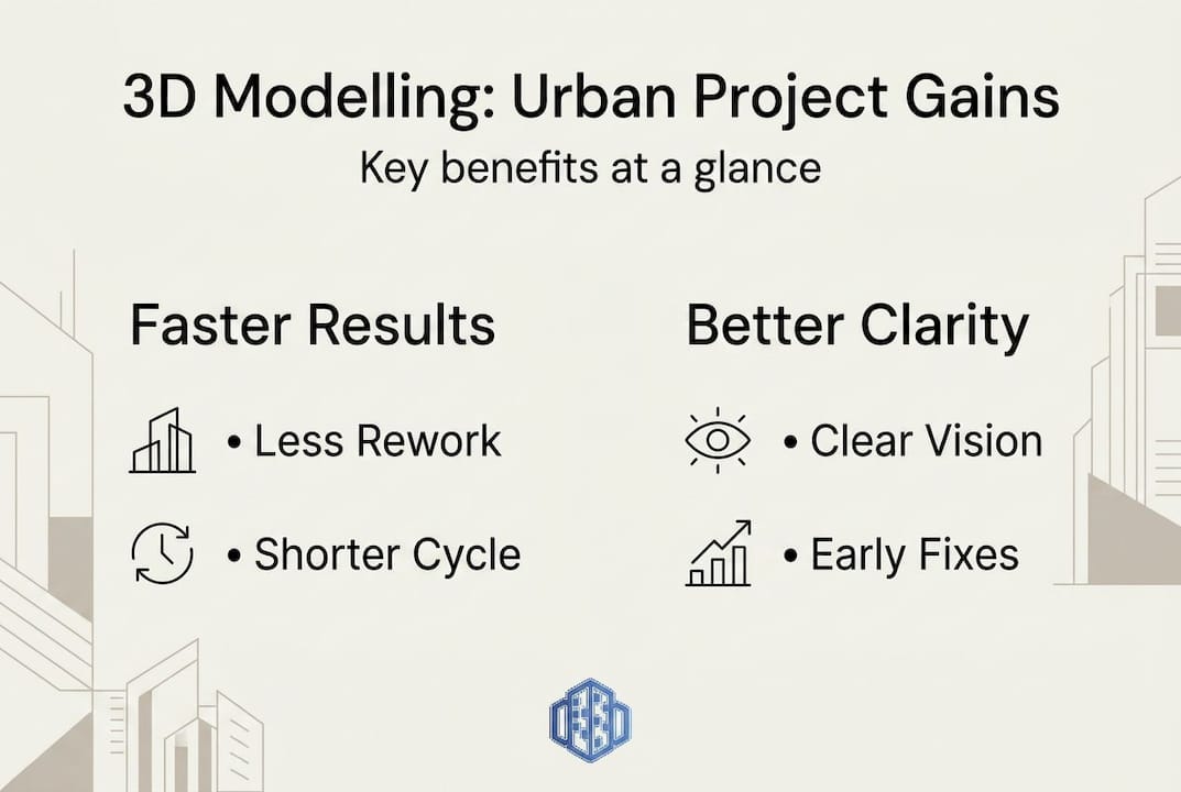
Visual clarity in communication
Boardroom presentations that include 3D renders and interactive models consistently generate faster sign-off from senior decision-makers. Community consultations that feature walkthrough animations see significantly higher engagement than those relying on printed plans. When members of the public can virtually stand at their front door and see how a proposed development will affect their sightlines, objections become more specific and productive rather than rooted in vague unease.
Clash detection before construction begins
One of the most financially valuable capabilities of 3D modelling is the ability to identify clashes, points where structural elements, MEP services, or infrastructure routes conflict, before a single piece of ground is broken. Research into 3D models enabling clash detection confirms that this capability reduces on-site conflicts and improves coordination across design disciplines. A clash discovered on screen costs almost nothing to fix. The same clash discovered during construction can cost tens of thousands of pounds.
Sustainability analysis integrated into design
Modern 3D platforms incorporate tools that analyse energy flow, sun path, wind patterns, noise propagation, and traffic movement. These are not separate post-design audits; they run alongside the modelling process itself. Planners and architects can test whether a proposed building orientation maximises passive solar gain, or whether a new road junction will create unacceptable noise levels for adjacent residential areas, before any commitment is made. This integration is one of the strongest arguments for why use 3D modelling from the earliest project stage.
| Benefit | Measurable outcome |
|---|---|
| Clash detection | Up to 40% reduction in on-site rework costs |
| Stakeholder approval speed | Planning approval cycles shortened by 20 to 30% |
| Design iteration | Parametric changes made in hours rather than days |
| Sustainability analysis | Energy performance optimised at design stage |
| Lifecycle cost modelling | Long-term maintenance costs identified earlier |
A practical 3D modelling workflow for urban planners
- Define project scope and collect existing site data, including topography, infrastructure records, and adjacent building information.
- Build or import a base 3D model incorporating the existing urban context.
- Overlay proposed design elements and run initial massing studies.
- Conduct clash detection and resolve conflicts at the model level.
- Integrate sustainability analyses: solar, acoustic, wind, and traffic.
- Produce stakeholder-facing visualisations, from photorealistic renders to interactive flythrough models.
- Incorporate feedback into the model and iterate rapidly.
- Use the finalised model as a living reference throughout construction and into the operational lifecycle.
Pro Tip: Integrating 3D modelling at the earliest feasible project stage, ideally during feasibility and concept design, maximises the return on your investment. Decisions made in the first 15% of a project’s lifecycle influence up to 80% of its total cost.
Practical applications: how leaders deploy 3D modelling
These benefits are no longer theoretical. City benchmarks and successful projects show how 3D modelling is already transforming practice on a global scale.
Cities that have invested in 3D urban modelling infrastructure are seeing tangible returns. The 2025 3D City Index benchmarks open 3D model maturity across major world cities, and the data is instructive. Helsinki currently scores 30.5 out of 47, placing it among the leading cities globally, with the average improvement across tracked cities sitting at 2.5 index points between 2022 and 2025. This trajectory signals growing data maturity and institutional commitment to 3D as core planning infrastructure, not a supplementary tool.
For planners and developers considering where to invest, studying these smarter city planning exemplars provides a concrete roadmap. The leading cities share common characteristics: open data policies, standardised 3D formats such as CityGML, and cross-departmental integration that allows planning, transport, utilities, and emergency services to share a single model environment.
Top five real-world use cases for 3D urban modelling
- Master planning and urban regeneration: Entire city districts are modelled to test phasing, density, and land-use mix before consultation begins, dramatically reducing planning objection rates.
- Transport infrastructure design: Road, rail, and cycling networks are modelled in three dimensions to identify sight-line issues, pedestrian conflict points, and topographic challenges before detailed engineering begins.
- Flood risk and resilience mapping: 3D terrain and building models are combined with hydrological data to simulate flood scenarios and identify vulnerable assets, supporting both insurance and planning decisions.
- Heritage impact assessments: New development proposals are visualised alongside protected buildings and conservation areas to assess visual impact accurately before submission.
- Stakeholder and community engagement: Interactive 3D portals allow residents to explore proposals at their own pace, generating more informed public responses and higher consultation quality.
These are not aspirational applications reserved for cities with unlimited budgets. Cloud-based tools have made high-quality 3D modelling accessible to mid-sized municipalities and private developers alike. Exploring 3D model examples from comparable projects can accelerate your technology selection process considerably.
Pro Tip: Before selecting a 3D platform, map your organisation’s five most common planning failure points, whether those are stakeholder objections, coordination errors, or approval delays. Then evaluate platforms specifically against those failure modes rather than by feature lists alone.
Limitations and choosing the right 3D approach
No tool is perfect. Let us examine what to watch out for and how to match your 3D approach to your project’s needs.
3D modelling offers genuine advantages, but practitioners who treat it as a cure-all will encounter frustration. Understanding the boundaries of the technology enables smarter deployment decisions and keeps project expectations realistic.
Common challenges in 3D urban modelling
- High computational demands: Detailed city-scale models require significant processing power. Running real-time environmental analyses across a large urban area can strain standard desktop hardware. Cloud-based processing is increasingly the practical solution here, distributing workloads across scalable infrastructure.
- Data quality and currency gaps: A 3D model is only as good as the data that feeds it. Many cities still lack comprehensive, up-to-date building footprint data, accurate height records, or reliable underground infrastructure mapping. Open data gaps remain a persistent limitation, particularly in rapidly developing regions.
- Complexity of emergent social behaviours: As research confirms, high computational demands and challenges in capturing emergent social behaviours and dispersed local knowledge mean 3D models are not fully predictive tools for dynamic urban complexity. They inform decisions; they do not make them.
Practical ways to mitigate these limitations
- Use cloud-based rendering and analysis platforms to overcome local hardware constraints.
- Adopt a hybrid data strategy: combine authoritative public datasets with field surveys and sensor data to fill gaps.
- Build model update cycles into project contracts so data does not become stale during long development programmes.
- Acknowledge model assumptions transparently in stakeholder presentations to maintain credibility.
Photorealistic vs symbolised 3D: matching model style to audience
Research consistently shows that photorealistic 3D models aid public and non-expert spatial understanding, while symbolised representations are better suited to expert audiences who prioritise data density over visual realism. In practice, most successful projects use both. A planning committee review might benefit from a symbolised model overlaid with zoning data and infrastructure networks, while the parallel public exhibition uses photorealistic renders and walkthrough animations.
Consulting a thorough city modelling software guide can help you identify which platforms support both output types and allow your team to switch between them efficiently. Equally important is structuring your 3D planning workflow to accommodate audience-specific outputs without duplicating work.
“The most effective urban modelling programmes combine rigorous digital representation with structured human interpretation. The model shows what is possible; experienced planners and communities determine what is desirable.”
This balance, between computational rigour and human judgement, is where the most mature 3D planning practices operate today.
Why 3D modelling is the foundation of tomorrow’s urban success
Most practitioners still treat 3D modelling as a presentation tool, something you produce at the end of a design process to illustrate decisions already made. This is a fundamental misunderstanding of where the value lies. The real power of 3D modelling sits at the front of the process, in the iterative, analytical phase where major decisions about form, programme, and infrastructure are still fluid.
Firms and municipalities that integrate 3D modelling as the central nervous system of their planning workflows, not a finishing touch, consistently outperform those that do not. They detect problems earlier, achieve stakeholder alignment faster, and deliver projects closer to budget. But technology alone does not achieve this. The difference-maker is retraining staff and redesigning workflows so that human insight connects seamlessly with digital models. Understanding how to create 3D city models effectively is the starting point, but embedding them in your decision-making culture is what sustains the advantage.
Pro Tip: Avoid the assumption that technology alone solves complexity. Invest equally in the processes and team capabilities that allow people to interrogate, challenge, and act on what the model reveals.
The organisations winning in urban development in 2026 are not simply those with the best software. They are the ones whose teams know how to ask the right questions of their models and turn the answers into confident, defensible decisions.
Ready to transform your urban projects with 3D modelling?
Armed with both practical understanding and strategic perspective, you are ready to take the next step and experience these benefits directly.
3dcityplanner.com brings together the tools you need to move from concept to construction-ready 3D models, with features including automatic building generation, line-of-sight visualisations, noise impact simulations, and full 4D timeline planning. Whether you are evaluating a new development site, preparing for a public consultation, or managing a complex multi-phase project, the platform gives you a single environment to design, analyse, and communicate with confidence.
Start with a free trial, no upfront payment required, and explore how the platform’s purpose-built urban planning tools can accelerate your next project. Browse case studies, access training resources, and see how leading planning teams are achieving measurably better outcomes. Visit 3dcityplanner.com to begin.
Frequently asked questions
How does 3D modelling improve stakeholder engagement in urban projects?
3D models provide realistic visualisations that allow all stakeholders, including those without technical training, to understand spatial proposals clearly. As research confirms, 3D modelling enhances decision-making by providing realistic representations of spatial relationships, scale, and integration with existing environments, making community consultation significantly more productive.
What is the main technical challenge with implementing 3D models in city planning?
The primary technical barriers are high computational demands and ensuring consistently accurate, up-to-date data across large urban areas, issues that cloud-based platforms increasingly address through scalable infrastructure.
Are photorealistic or symbolised 3D models better for urban planning?
Neither format is universally superior. Photorealistic 3D aids public understanding, while symbolised models suit expert audiences; combining both within a single project produces the best overall outcomes.
How do cities benchmark progress in 3D urban modelling?
Cities measure their 3D data maturity using structured tools such as the 2025 3D City Index, which scores openness, completeness, and integration of 3D urban datasets across dozens of leading global cities.
Recommended
- Why Use 3D Modelling in Urban Design Projects – 3D Urban Development
- How to Create 3D City Models for Urban Planning Projects – 3D Urban Development
- 3d Building Modeling Tutorial for Efficient Urban Planning – 3D Urban Development
- Leverage 3D modelling for smarter city planning in 2026 – 3D Urban Development


