What is urban scenario modelling for planners?

Urban scenario modelling is frequently misunderstood as a visualisation exercise. In practice, what is urban scenario modelling comes down to something far more demanding: a structured method for combining qualitative narratives about the future with quantitative computational simulations that translate those narratives into comparable, measurable outcomes. It is not about predicting what will happen. It is about systematically exploring what could happen under different conditions, so that planners, architects, and city officials can make decisions with their eyes open to uncertainty. This article explains the core concepts, methods, tools, and applications you need to know.
What is urban scenario modelling, exactly?
At its most precise, urban scenario modelling is the practice of constructing multiple plausible futures for a city or urban area, then running computational models against each future to compare outcomes across a range of planning criteria. A 2024 study defines scenario analysis as a process that evaluates different plausible futures by combining qualitative narratives with quantitative models to generate comparable urban outcomes.
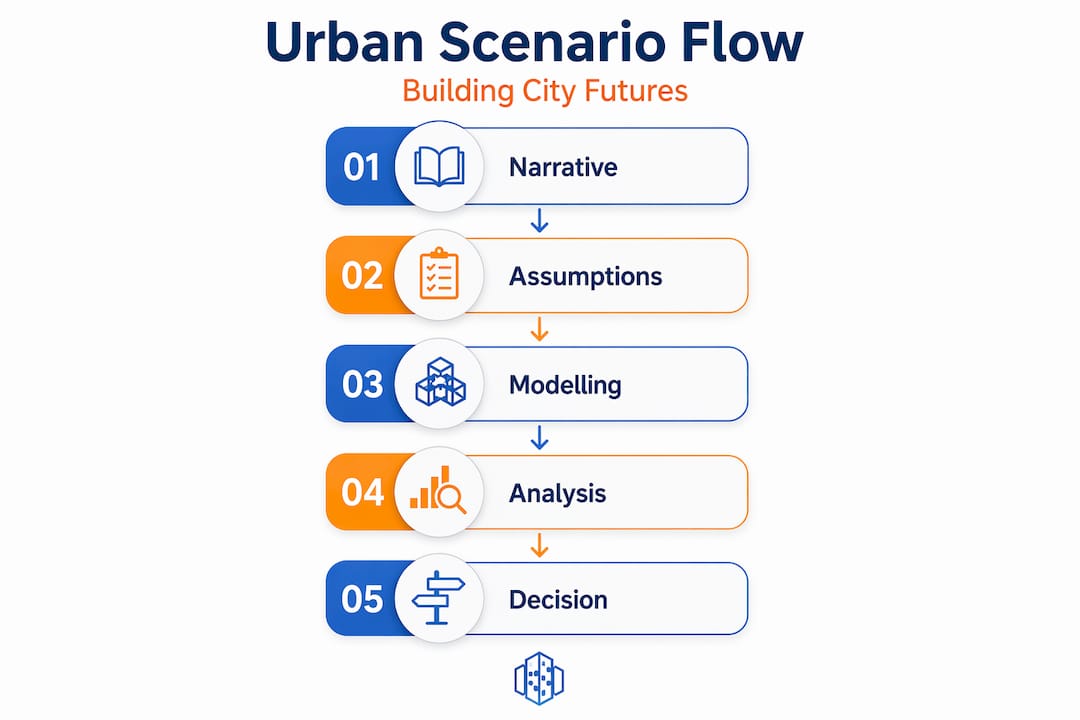
The definition of urban modelling rests on two distinct but inseparable components. First, the scenario narrative: a story built from assumptions about how key drivers of change, such as population growth, climate policy, or economic investment, will evolve over time. Second, the quantitative model: a computational system that translates those narrative assumptions into numeric outputs such as land-use change, traffic volumes, carbon emissions, or housing demand.
The critical discipline is keeping these two components clearly linked. When assumptions shift in the narrative, the corresponding model parameters must shift with them. This transparency is what separates genuine scenario modelling from ad hoc guesswork. Separating scenario narratives from model runs explicitly is what allows stakeholders to understand which assumptions are actually driving differences in outcomes.
Common modelling techniques used to implement these scenarios include:
- Agent-based modelling (ABM): Simulates the behaviour of individual actors, such as households, developers, or commuters, and observes how their collective decisions shape the urban environment.
- Cellular automata: Models land-use change by applying transition rules across a spatial grid, making it well suited to simulating urban sprawl or densification patterns.
- System dynamics: Captures feedback loops between sectors, such as housing supply, population, and economic output, over long time horizons.
- Computational fluid dynamics (CFD): Used for fine-grained simulations of wind, heat, and air quality in the urban environment.
Pro Tip: When building your first scenario model, write the narrative assumptions in plain language before touching any modelling software. This forces clarity on what you are actually testing and makes it far easier to explain your results to non-technical stakeholders later.
Modern computational methods and tools
Urban scenario modelling today operates across a spectrum of computational methods, from relatively simple spatial allocation tools to fully dynamic simulations that run forward in time and update as new data arrives. Understanding where each method sits on that spectrum helps you select the right approach for the planning question at hand.
The table below contrasts the main approaches across key dimensions:
| Method | Nature | Typical use case | Time dimension |
|---|---|---|---|
| Cellular automata | Rule-based spatial | Land-use change modelling | Dynamic |
| Agent-based modelling | Behaviour simulation | Transport, housing market | Dynamic |
| Digital twins | Data-integrated replica | Real-time monitoring and forecasting | Continuous |
| System dynamics | Feedback loop modelling | Long-term resource and population trends | Dynamic |
| GIS spatial allocation | Static spatial analysis | Zoning, infrastructure siting | Static |
| CFD simulation | Physics-based fluid simulation | Microclimate, air quality | Dynamic |
Dynamic urban simulations such as agent-based modelling and digital twins represent a significant step beyond static mapping. Where a static model shows you a snapshot of what the city looks like today, a dynamic simulation runs forward in time, letting you observe how the city evolves under different policy conditions. Digital twins in particular function as living simulation environments, continuously fed by real sensor data, making them especially powerful for monitoring how actual urban conditions compare to modelled forecasts.

Planning Support Systems (PSSs) have undergone a parallel evolution. Earlier PSSs were largely analytical tools used by technical specialists in isolation. PSSs have since shifted toward participatory, interactive modelling environments that enable co-design, collaborative mapping, and real-time exploration of scenarios by diverse user groups. The integration of GIS data in planning underpins nearly all modern scenario platforms, providing the spatial foundation on which all other models are built.
The most recent development is the incorporation of artificial intelligence and machine learning into decision support systems. These systems can evaluate thousands of potential scenario outcomes across multiple criteria simultaneously, a task that would take human analysts weeks to complete manually.
Pro Tip: When selecting a modelling tool for a specific project, start by identifying whether your planning question requires a dynamic simulation or a static spatial analysis. Dynamic simulations demand substantially more data and calibration time. For many zoning or land-use decisions, a well-configured GIS allocation model may be entirely sufficient.
Stakeholder participation and iterative reasoning
One of the most consequential shifts in urban scenario planning over the past decade is the move away from expert-driven, top-down forecasts toward collaborative, participatory processes. This is not simply a political or procedural preference. It reflects a genuine recognition that urban planning decisions involve multiple competing values, and that no single technical model can resolve those value conflicts on its own.
Participatory modelling supports social learning by giving diverse stakeholders direct experience with how different assumptions lead to different outcomes. When a community group or elected official can see that their preferred development scenario produces more traffic congestion than an alternative, the model becomes a shared reference point for negotiation rather than a tool that produces a single authoritative answer.
“Planning Support Systems should be designed as participatory objects engaging stakeholders in negotiation and learning, embedding uncertainty communication as integral.” (Evolving from Rules to Learning in Urban Modeling)
That said, there are real challenges in communicating complex models to audiences without a technical background. The following approaches have been shown to improve accessibility in practice:
- Canned scenarios: Pre-built, named scenarios (such as “compact growth” versus “dispersed growth”) that allow stakeholders to explore outcomes without needing to understand model parameters directly.
- Interactive workshops: Facilitated sessions where participants adjust scenario assumptions in real time and observe how outputs change, building intuition about model behaviour.
- Visual dashboards: Graphical interfaces that display key metrics, such as housing affordability, carbon emissions, and travel time, side by side across scenarios.
- Narrative summaries: Plain-language descriptions of each scenario that accompany technical outputs, keeping the qualitative story connected to the quantitative results.
Interactive planning support systems that enable real-time exploration and negotiation of alternative futures are now considered best practice. The goal is iterative reasoning: repeatedly revisiting assumptions, testing how sensitive outcomes are to changes in those assumptions, and refining the scenario set as stakeholder understanding deepens.
Applications and benefits for sustainable cities
The applications of urban scenario modelling span the full range of planning disciplines, from transport and land use to environmental resilience and economic development. Below are the most established and growing areas of application, along with what each delivers in practice.
- Transport demand prediction. Scenario models that link macro-level pathways to high-resolution spatial data can generate detailed forecasts of how different urban growth patterns will affect travel demand, mode share, and infrastructure requirements decades into the future.
- Land-use planning. Cellular automata and agent-based models help planners test how zoning changes, density targets, or greenfield versus brownfield development policies will alter the physical form of the city over time.
- Environmental impact assessment. CFD simulations and digital twin environments allow planners to evaluate microclimate effects, urban heat island intensity, and air quality implications of proposed developments before any ground is broken.
- Multi-criteria sustainability evaluation. Machine learning-based decision support systems can simultaneously compare scenario outcomes across social, economic, and environmental criteria, producing ranked assessments that make trade-offs explicit.
- Risk preparedness and adaptive planning. Scenario modelling is increasingly used to stress-test city plans against climate hazards, demographic shocks, or economic downturns, identifying which strategies remain viable across the widest range of futures.
The table below summarises key benefits by planning domain:
| Planning domain | Key benefit of scenario modelling |
|---|---|
| Transport | Quantified demand forecasts under multiple growth assumptions |
| Land use | Tested zoning alternatives before policy commitment |
| Environment | Pre-construction impact assessment using dynamic simulation |
| Sustainability | Explicit trade-off analysis across social and environmental criteria |
| Risk and resilience | Identification of strategies robust to uncertain future conditions |
Effective urban scenario modelling requires explicit handling of multiple criteria and uncertainty to convert model outputs into decisions planners can actually act on. The practical value is not in the model outputs themselves but in the structured conversation those outputs make possible among planners, politicians, and the public. Platforms that support urban infrastructure modelling across these domains help teams move from raw scenario data to planning decisions far more efficiently.
My perspective: what the models cannot tell you
I have seen urban scenario modelling done well and done poorly, and the dividing line is rarely the sophistication of the software. What separates genuinely useful scenario work from expensive noise is discipline in how narratives and models are kept connected and transparent.
In my experience, the most common failure is treating the model as an oracle. When a team presents scenario outputs without clearly explaining which assumptions produced them, stakeholders cannot meaningfully challenge the results. The model becomes a black box, and the planning process loses the critical reasoning it was supposed to enable. Scenario analysis is designed to cultivate systematic thinking about plausible futures, not to eliminate the need for judgement.
I have also found that teams consistently underestimate how much time genuine stakeholder engagement requires. Running a workshop with a visual interface is not the same as building shared understanding. It takes multiple sessions, repeated exposure to the scenarios, and patient facilitation before diverse stakeholder groups develop enough intuition to contribute meaningfully to the modelling process.
My strongest caution is around AI-powered decision support systems. They offer real analytical power, but building systems that handle uncertainty effectively remains a genuine challenge. Treat any AI-generated ranking of scenarios as a starting point for expert review, not as a conclusion. The model informs the decision. The decision remains yours.
— Anne
Put scenario modelling into practice with 3dcityplanner
Understanding urban scenario modelling conceptually is the first step. Applying it to real projects requires tools that match the method to the data and the team you are working with.
3dcityplanner brings together digital twin technology and GIS-based spatial analysis in a single platform designed for urban planning professionals. The platform supports automatic building generation, sound simulation, sightline analysis, and 4D timeline planning, giving you the technical foundation to run and compare urban scenarios without switching between disconnected tools. Whether you are modelling transport impacts, testing density scenarios, or preparing for a stakeholder presentation, 3dcityplanner provides the interactive environment that makes scenario modelling accessible and credible. Explore the platform with a no-commitment trial at 3dcityplanner.com.
FAQ
What is urban scenario modelling in simple terms?
Urban scenario modelling is the process of building multiple plausible versions of a city’s future and using computational simulations to compare their outcomes. It combines qualitative narratives about change drivers with quantitative models to support planning decisions under uncertainty.
How does urban scenario modelling differ from forecasting?
Forecasting aims to predict a single most likely future, while urban scenario modelling deliberately constructs several distinct futures to explore uncertainty. Scenario planning is not forecasting. Its purpose is to prepare decision-makers for a range of possibilities, not to select one.
What are the key elements of urban scenario modelling?
The key elements are scenario narratives (qualitative stories built from assumptions about future drivers), quantitative computational models (such as agent-based models or digital twins), GIS spatial data, and participatory engagement processes that connect technical outputs to stakeholder decisions.
Which computational methods are most commonly used?
The most widely used methods include agent-based modelling, cellular automata, system dynamics, digital twins, and computational fluid dynamics. The choice of method depends on the planning question, the available data, and whether a static or dynamic simulation is required.
Can small planning teams use urban scenario modelling effectively?
Yes. Accessible Planning Support Systems and platforms such as 3dcityplanner have substantially reduced the technical barrier. Using pre-built scenario frameworks and GIS-integrated tools, small teams can conduct meaningful scenario analysis without specialist modelling expertise for every component.