Practical guide to modern urban planning with 3D technology

Urban planners, architects, and real estate developers are under mounting pressure to deliver smarter, more resilient cities faster than ever before. Traditional 2D workflows and static renders simply cannot keep pace with the complexity of modern development challenges, from housing shortfalls to climate resilience. In 2026, the shift towards GIS-integrated 3D models and digital twins is no longer optional. It is the foundation of evidence-based, future-proofed urban planning. This guide walks you through each stage of the process: assembling your data, building scenarios, engaging stakeholders, optimising outcomes, and avoiding the pitfalls that derail even well-resourced teams.
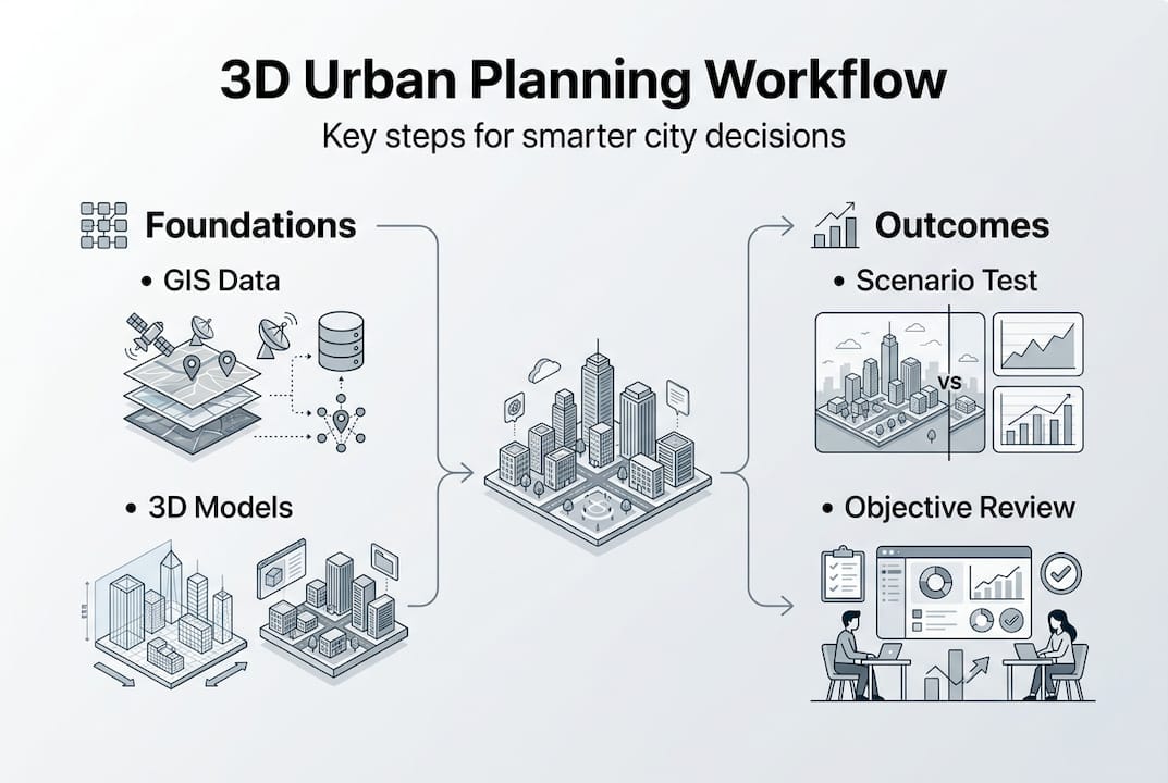
Key Takeaways
| Point | Details |
|---|---|
| Build on strong data | A comprehensive evidence base using GIS and 3D data is crucial for smarter planning decisions. |
| Leverage digital twins | Interactive, real-time 3D models enable robust scenario testing and better project outcomes. |
| Engage for impact | Immersive 3D visuals foster stronger public and stakeholder engagement throughout the process. |
| Optimise and review | Continuous review and multi-objective analysis secure measurable gains in energy, satisfaction, and resilience. |
| Balance tech and people | Hybrid digital twin solutions and staff upskilling help urban planners avoid integration pitfalls and adapt to future needs. |
Establishing a robust evidence base with GIS and 3D models
Every successful urban project begins with data. The core methodology for city master planning starts with assembling a complete evidence base: GIS layers, demographic profiles, land use records, and infrastructure inventories. Without this foundation, even the most sophisticated 3D model is built on assumptions rather than facts.
GIS platforms allow planners to layer spatial data from multiple sources, including transport networks, flood risk zones, population density, and ownership boundaries. LiDAR surveys add a further dimension by capturing precise elevation and building geometry data, which feeds directly into creating accurate 3D city models for analysis and visualisation. Together, these tools form the backbone of any credible planning process.
The table below summarises the essential tools, data sources, and outputs at this stage:
| Tool | Data source | Output |
|---|---|---|
| GIS platform | Land registry, census, utilities | Spatial analysis layers |
| LiDAR survey | Aerial or ground-based sensors | 3D terrain and building geometry |
| Demographic modelling | National statistics, local surveys | Population and demand projections |
| Open data portals | Government and municipal datasets | Baseline infrastructure mapping |
Key data types to gather at this stage include:
- Land use and zoning records to understand current constraints and opportunities
- Transport and accessibility data to model movement patterns and connectivity
- Environmental data including flood plains, air quality, and green space coverage
- Socioeconomic indicators to align development with community need
- Heritage and conservation designations to flag sensitive areas early
Projects like Singapore’s Virtual Singapore demonstrate what is achievable when a city commits to a thorough evidence base from the outset, enabling everything from solar analysis to emergency response planning within a single 3D environment.
Pro Tip: Set up repeatable data ingestion workflows so your evidence base can be refreshed annually without starting from scratch. Automate where possible using API connections to live data sources.
Developing and testing urban scenarios with 3D digital twins
Once your evidence base is assembled, the next step is scenario development. This is where digital twins truly distinguish themselves from conventional tools. Digital twins are dynamic, data-connected 3D models of urban areas that enable real-time simulation, scenario testing, and stakeholder engagement, in direct contrast to static 3D renders which simply show a fixed moment in time.
Configuring a digital twin for scenario analysis involves several structured steps:
- Import your base model using GIS and LiDAR data, ensuring geometric accuracy at street and building level
- Define scenario parameters such as density targets, land use changes, transport upgrades, or climate adaptation measures
- Run simulations to assess impacts on housing capacity, energy demand, traffic flow, and environmental performance
- Compare outputs across scenarios using real-time metrics to identify the most balanced solution
- Iterate by adjusting parameters and re-running simulations until the preferred scenario meets all objectives
The comparison below illustrates the practical differences between open and commercial 3D platforms:
| Feature | Open models | Commercial platforms |
|---|---|---|
| Transparency | High | Moderate |
| Real-time analysis | Limited | Advanced |
| Workflow automation | Manual | Automated |
| Integration support | Variable | Structured |
| Cost | Lower upfront | Subscription-based |
ArcGIS Urban enables 3D scenario modelling by converting zoning regulations into 3D form, auto-generating building massing, and delivering real-time metrics for households, jobs, and energy use alongside site suitability analysis. This level of automation significantly reduces the time between concept and evidence-based decision.
“Virtual Singapore demonstrated that a well-built digital twin reduces planning costs and decision timelines substantially, while enabling functions that were previously impossible, such as city-wide shadow analysis and real-time scenario impact modelling.”
Explore the broader role of digital twins and their planning impacts to understand how leading cities are applying these tools at scale.
Engaging stakeholders and ensuring transparency with immersive visuals
Scenario modelling is only valuable if its outputs can be communicated clearly to decision-makers, communities, and investors. Immersive 3D models close the gap between technical analysis and public understanding. When stakeholders can walk through a proposed development virtually, their feedback becomes more informed and their buy-in more genuine.
Effective techniques for increasing stakeholder engagement include:
- Public web portals that allow residents to explore 3D proposals at their own pace
- Interactive simulations showing before-and-after comparisons of key metrics such as sunlight, noise, and green space
- Transparent data dashboards linked to the 3D model so that any claim can be verified in real time
- Workshop tools that let participants adjust parameters and immediately see the consequences
- Accessibility features ensuring models are usable across devices and by non-technical audiences
The PAS Memo digital twin framework provides guidance on structuring public engagement within digital planning processes, including how to manage data privacy and ensure that community input is meaningfully integrated.

The impact of structured digital engagement is measurable. Rules-based digital planning in Croydon increased housing delivery potential by 6,000 units per year through consistent, transparent site assessments. That is a direct result of removing subjectivity from the process and replacing it with data-driven, visually communicable evidence.
Pro Tip: Address data privacy and interoperability requirements before your first public engagement session. Retrofitting compliance is far more costly than building it in from the start.
For further reading on how virtual environments support better planning decisions, see enhancing planning with virtual cities and practical digital twin urban planning strategies.
Optimising urban outcomes through scenario review and multi-objective analysis
Reaching stakeholder consensus is a milestone, not a finish line. The most effective urban planning processes treat optimisation as an ongoing discipline rather than a one-off exercise. Setting up a structured review schedule ensures that plans remain relevant and responsive as conditions change.
A practical optimisation cycle looks like this:
- Annual scenario refresh for the first five years, updating inputs with new demographic, economic, and environmental data
- Five-year master plan review to assess whether strategic objectives are being met and to incorporate emerging priorities
- Metrics audit comparing actual outcomes against projected targets for energy, housing, transport, and wellbeing
- Constraint balancing to resolve tensions between competing objectives such as density versus green space
- Scenario iteration using updated data to model revised approaches before committing to implementation changes
The results of rigorous multi-objective optimisation are striking. Advanced 3D digital twin analysis has delivered energy use reductions of 99 kWh per square metre per year, onsite generation improvements of 42.5%, user satisfaction gains of 32.8%, and safety risk reductions of 63.2%. These are not marginal improvements. They represent transformative gains achievable through disciplined use of the right tools.
The table below illustrates typical before-and-after outcomes from a structured optimisation programme:
| Metric | Before optimisation | After optimisation |
|---|---|---|
| Energy use (kWh/m²/year) | Baseline | Reduced by 99 |
| Onsite energy generation | Standard | +42.5% |
| User satisfaction | Baseline | +32.8% |
| Safety risk incidents | Baseline | -63.2% |
Expert guidance recommends reviewing master plans every five years and refreshing scenarios annually during the first five years, with a priority on semantic data to support advanced simulations. Explore advanced planning strategies and 3D CityGML standards in the EU to understand how leading authorities structure their review cycles.
Pro Tip: Use multi-objective analytics tools that allow you to weight competing priorities. A single-objective focus on density, for example, will consistently underperform against a balanced approach that also accounts for energy, safety, and liveability.
Avoiding common technical pitfalls: integration, upskilling, and standards
Even well-funded planning teams encounter avoidable setbacks. The most common stem not from choosing the wrong tool but from underestimating the organisational and technical groundwork required to make any tool work well.
Data integration complexity and staff upskilling are consistently cited as the leading pitfalls in 3D urban planning implementations. A hybrid approach using open standards such as CityGML alongside commercial platforms is widely recommended to balance flexibility with analytical power. See EU CityGML benchmarking for a practical overview of how European cities are navigating this balance.
Practical solutions to the most common pitfalls include:
- Adopt open or hybrid data standards from the outset to prevent vendor lock-in and ensure long-term portability
- Invest in structured training programmes so that your team can use tools confidently and interpret outputs accurately
- Run pilot projects in defined areas before scaling to city-wide implementation
- Document integration protocols so that data flows between GIS, 3D modelling, and simulation tools are reliable and repeatable
- Engage IT and data governance teams early to align technical infrastructure with planning ambitions
“Open models such as Helsinki’s excel in transparency and reusability but lag in real-time analysis capabilities. Commercial platforms such as VU.CITY, 3D Cityplanner, and ArcGIS Urban provide advanced analytical workflows. The strongest outcomes consistently come from hybrid approaches that draw on the strengths of both.”
For a thorough grounding in how digital twin standards are evolving, consult the digital twin city guide alongside GeoAI developments in planning.
Why the future of urban planning depends on hybrid digital twins
There is a persistent assumption in the sector that the choice between open and proprietary tools is a binary one. It is not. The strongest planning outcomes come from hybrid ecosystems where open models provide transparency and reusability, and commercial platforms such as VU.CITY, 3D Cityplanner, and ArcGIS Urban deliver the advanced analytical workflows that open models currently cannot match.
But here is the part that often gets overlooked: the tool stack matters far less than the people using it. Institutional agility, a willingness to iterate, and sustained investment in skills are what separate cities that achieve transformative outcomes from those that produce impressive visualisations and little else. The technology is ready. The question is whether your organisation is structured to use it well.
The most overlooked lesson in digital planning is this: prioritise adaptable, interoperable solutions and invest in human capital with the same rigour you apply to platform selection. Agility and skills will outlast any single tool.
Plan your city’s future with advanced 3D technology
3D Cityplanner brings together the full range of capabilities described in this guide within a single, accessible platform designed for urban planning professionals.
From GIS integration and automated scenario modelling to immersive stakeholder engagement tools and 4D project timelines, 3D Cityplanner supports every stage of the planning process. The platform is built for teams who need to move quickly without sacrificing analytical rigour. Whether you are managing a city-wide master plan or a targeted redevelopment project, explore 3D Cityplanner to see how it fits your workflow and book a trial without any upfront commitment.
Frequently asked questions
What is a digital twin in urban planning?
A digital twin is a dynamic, data-connected 3D model representing urban areas for real-time simulation, scenario analysis, and ongoing monitoring. Unlike static models, it updates as conditions change and supports continuous decision-making.
How can 3D digital twins improve stakeholder engagement?
They offer immersive, interactive models that make proposals accessible to non-technical audiences and allow real-time collaboration and feedback. This leads to more informed public input and faster consensus-building.
What is the difference between open 3D models and commercial digital twin platforms?
Open models prioritise transparency and reusability, while commercial platforms offer advanced analysis and workflow automation. Hybrid solutions combine both advantages for the strongest overall outcomes.
How often should urban plans be reviewed using 3D technology?
Review master plans every five years and refresh scenarios annually during the first five years, using up-to-date semantic data to support advanced simulations and accurate projections.
What are the main pitfalls to avoid with 3D urban planning?
Common pitfalls include data integration challenges and skills gaps, vendor lock-in, and failing to run pilot projects before scaling. Adopting hybrid open standards and investing in training significantly reduces these risks.
Recommended
- Urban infrastructure planning guide for advanced 3D optimisation – 3D Urban Development
- Urban Development Workflow for Efficient 3D Planning – 3D Urban Development
- 3D City Modeling Software: The Ultimate Guide for Urban Planners & Developers - 3D Gebiedsontwikkeling
- How to create an urban masterplan with 3D technology – 3D Urban Development


