What is urban data modelling for city planners?

Urban data modelling is frequently misunderstood as little more than 3D visualisation or digital mapping. In reality, it is a dynamic, multi-layered process that underpins modern city management and intelligent urban planning. Understanding what is urban data modelling means recognising it as the structured integration, processing, and analysis of heterogeneous urban datasets to support decision-making at every scale, from individual buildings to entire metropolitan regions. This guide breaks down the core concepts, key techniques, real-world applications, and the challenges that every urban planner and data scientist should know.
What is urban data modelling: core concepts and data types

The industry term most closely aligned with advanced urban data modelling practice is City Information Modelling (CIM). Where traditional models captured a static snapshot of a city, CIM integrates multi-source urban data through a full lifecycle of acquisition, fusion, processing, analysis, and application, enabling intelligent urban planning in real time.
Urban data modelling draws on a wide spectrum of data types. Understanding what each contributes is fundamental before attempting any modelling workflow.
- Geospatial data: Points of Interest, road networks, land parcels, and building footprints form the spatial backbone of any urban model.
- Sensor and IoT data: Real-time feeds from traffic counters, environmental sensors, and utility meters provide the temporal dimension that static maps cannot offer.
- BIM data: Building Information Models contain detailed geometric and semantic data about individual structures, including materials, floor areas, and system specifications.
- Mobility data: Passenger flows, vehicle counts, and pedestrian movement patterns reveal how people actually use urban space.
- Demographic and socioeconomic data: Population distributions, income levels, and service-access metrics contextualise spatial patterns with human meaning.
The critical concept here is multi-source data fusion. Raw datasets from these categories rarely share the same format, coordinate system, or level of detail. Effective urban data modelling requires fusing them into a coherent, queryable model without losing the integrity of each source.
It is also worth distinguishing between geometric data (the shape and position of urban objects) and semantic data (the attributes and relationships that give those objects meaning). A building outline on a map is geometric. The same building labelled with its use class, construction year, and energy rating is semantic. Both are necessary. Neither alone is sufficient for advanced urban analytics.
Key enabling technologies span several disciplines:
- GIS for spatial data management and analysis
- BIM for detailed building and infrastructure modelling
- IoT for real-time sensor integration
- Machine Learning for pattern recognition and predictive modelling
Pro Tip: When starting a new urban modelling project, audit your data sources before selecting your modelling approach. Mismatched data types and coordinate systems are the most common cause of project delays, not algorithmic complexity.
From raw data to decisions: urban analytics in practice
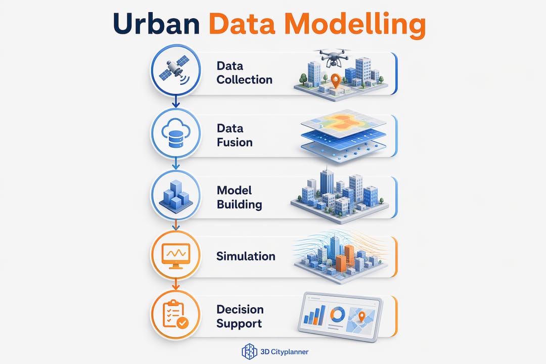
Urban data modelling does not end at building a model. Its value lies in what that model enables: specifically, the capacity for urban analytics using big data, GIS, remote sensing, and machine learning to interpret urban phenomena and support planning decisions.
Here is how a structured urban data analysis workflow typically progresses:
- Data acquisition and preparation: Collect raw data from geospatial, sensor, BIM, and demographic sources. Clean inconsistencies and align coordinate systems.
- Feature engineering: Enrich raw spatial data with derived attributes such as building height, land use classification, accessibility scores, and noise exposure levels. Feature engineering elevates raw input into attributes that machine learning models can meaningfully interpret.
- Model construction: Build the integrated urban model, whether a 2D GIS layer stack, a 3D city model, or a full digital twin with live data feeds.
- Scenario testing: Run simulations to test planning decisions before they are implemented. How will a new transit corridor affect land use patterns? What happens to flood risk if a development proceeds on a specific site?
- Output and visualisation: Generate maps, reports, dashboards, and 3D visualisations that communicate findings to planners, politicians, and the public.
The outputs of this process are genuinely transformative. Predictive urban planning, which uses historical patterns to forecast future conditions, depends entirely on well-structured modelling at the foundation. Smart city goals around sustainability, efficiency, and resilience are not achievable through good intentions alone. They require data-driven city management that connects real-time sensor feeds to decision-support tools.
One figure worth holding in mind: urban digital twin applications now span transport optimisation, infrastructure management, emergency response, and sustainability initiatives, demonstrating just how broad the practical reach of urban data modelling has become.
Modelling techniques: comparisons and integration challenges
Not all urban modelling approaches are equal, and understanding the trade-offs is what separates a theoretically sound plan from one that actually works in practice.
BIM and GIS integration
The integration of BIM and GIS is one of the most discussed topics in urban data analysis, and for good reason. The two systems are fundamentally different in how they represent the world. BIM excels at detailed geometric and semantic representation of individual buildings. GIS excels at spatial analysis across large areas. Combining them requires converting geometric and semantic data separately, because their underlying data structures diverge significantly. For a deeper look at how this works in practice, the article on BIM integration benefits covers the key technical and operational considerations.
Level of Detail (LoD)
The concept of Level of Detail manages geometric complexity across scales. A city-wide traffic simulation does not need the same resolution as a building energy audit. Multi-LoD models allow planners to select the appropriate level of geometric detail for each analysis task, improving performance and reducing unnecessary processing load.
| Approach | Strengths | Limitations |
|---|---|---|
| Static GIS models | Established workflows, wide tool support | Cannot reflect real-time change |
| Dynamic digital twins | Real-time updates, scenario simulation | High data infrastructure requirements |
| BIM-GIS integration | Rich semantic and geometric detail | Complex data conversion processes |
| AI-powered urban models | Pattern recognition, predictive capability | Requires large, high-quality datasets |
Data lifecycle challenges
The uncomfortable reality of data modelling in cities is that data lifecycle issues, including access, quality, privacy, and governance, create more operational bottlenecks than algorithmic complexity ever does. Data silos between municipal departments, inconsistent data quality across sources, and privacy constraints on mobility data all create friction that no modelling technique can resolve on its own.
Urban data governance models are now recognised as foundational infrastructure, not an afterthought. A governance model that harmonises technology, organisational processes, and data culture is what makes multi-source integration sustainable over time.
Pro Tip: Establish data ownership and update protocols at the start of any CIM project. Models that rely on manually updated datasets quickly become outdated, and outdated models produce misleading analysis.
Practical applications of urban data modelling
The real test of any methodology is what it enables in the field. Urban data modelling has moved well beyond academic prototypes into operational city planning workflows across the world.
Consider the following applications that are actively in use:
- Transport planning: CIM frameworks integrate traffic sensor data, public transport usage, and land use models to optimise route planning and identify congestion before it becomes chronic.
- Infrastructure optimisation: Water, electricity, and waste management networks modelled within a CIM environment can be monitored in real time, with predictive maintenance triggered by sensor thresholds rather than fixed schedules.
- Emergency response: Multi-scale data fusion combining building data, population distributions, and road network models enables emergency services to plan responses to scenarios before they occur.
- Environmental management: Air quality, noise, and flood risk models built on integrated urban datasets allow planners to assess the cumulative environmental impact of development decisions.
- Resource allocation: Demographic and service-access data combined with spatial models help decision-makers direct investment to areas of genuine need rather than political priority.
The addition of 4D planning, which layers time as a fourth dimension onto 3D city models, takes these applications further still. Planners can visualise how a city will change over months or years under different development scenarios, comparing outcomes side by side before committing resources. For an overview of how urban data sources feed into 3D modelling workflows, the 3dcityplanner knowledge base provides a practical starting point.
| Application area | Key data inputs | Primary benefit |
|---|---|---|
| Transport planning | Traffic sensors, transit data, land use | Congestion reduction, route optimisation |
| Infrastructure management | Utility sensors, asset registers | Predictive maintenance, cost reduction |
| Environmental assessment | Air quality, noise, flood models | Risk-aware development decisions |
| Emergency response | Building data, population, road networks | Faster, better-coordinated response |
| Resource allocation | Demographics, service access, spatial data | Equitable investment targeting |
My perspective on where urban data modelling is headed
I have spent considerable time working with urban data projects across different city contexts, and one pattern repeats itself. Planners and data scientists tend to overestimate the difficulty of the modelling and underestimate the difficulty of the data. The algorithms are not the hard part. Getting clean, current, and permission-cleared data from five different municipal departments is the hard part.
What I find genuinely encouraging is the growing recognition that data governance and interoperability are not technical problems. They are organisational ones. The cities making the most progress with CIM are those where a chief data officer has authority across departmental boundaries, not just within one silo.
On the BIM-GIS integration question specifically, I have seen projects stall for months because teams did not agree upfront on which level of detail was required for which analysis. The geometric and semantic data conversion process is manageable once the requirements are clear. But without that clarity, you end up rebuilding models repeatedly.
The ethical dimension also deserves more attention than it currently receives. Mobility data, in particular, carries significant privacy implications. As AI-powered analytics become more capable of inferring individual behaviour from aggregate datasets, the governance frameworks need to keep pace.
My practical advice is this: prioritise your data infrastructure before your modelling ambitions. Build governance into your project from day one. And treat your urban model as a living system that requires maintenance, not a deliverable you complete and hand over.
— Anne
Explore urban data modelling tools with 3dcityplanner
Urban data modelling concepts are powerful on paper. What makes them operational is having the right software environment to apply them.
3dcityplanner is a professional platform built specifically for urban planners, architects, and data scientists working with complex city environments. It supports BIM and GIS integration, automatic building generation, line-of-sight analysis, noise simulation, and 4D planning with timeline-based project phasing. All of these capabilities sit within a single interface that allows teams to model, analyse, and communicate urban scenarios without switching between disconnected tools.
For professionals exploring urban planning software options, 3dcityplanner offers a trial period with no upfront commitment, making it straightforward to test the platform against your specific project requirements. You can review the full platform feature list to see exactly which modelling and analysis capabilities are available before you begin.
FAQ
What is urban data modelling?
Urban data modelling is the structured process of integrating, processing, and analysing heterogeneous urban datasets, including geospatial, BIM, sensor, and demographic data, to support intelligent city planning and management decisions.
How does urban data modelling differ from traditional GIS mapping?
Traditional GIS mapping captures static spatial data, while urban data modelling incorporates dynamic, real-time data from multiple sources including IoT sensors and BIM, enabling predictive analytics and scenario simulation rather than simple visualisation.
What is urban analytics and how does it relate to data modelling?
Urban analytics is the application of computational techniques, including machine learning and spatial analysis, to interpret urban patterns and phenomena. It depends on well-structured urban data models as its input, making the two practices closely linked.
What are the biggest challenges in data modelling for cities?
The most significant challenges are not algorithmic. They involve data lifecycle management issues such as data quality, privacy constraints, interoperability between systems, and governance across multiple organisations.
What is a digital twin in the context of urban data modelling?
A digital twin is a living simulation environment that mirrors a real city using continuously updated data from sensors, BIM models, and GIS layers, allowing planners to test decisions in a virtual environment before implementing them in the physical world.
Recommended
- How to Create 3D City Models for Urban Planning Projects – 3D Urban Development
- Step by step city modelling guide for urban planners – 3D Urban Development
- Urban Planning Data Sources: Powering 3D Modelling – 3D Urban Development
- 3D City Modeling Software: The Ultimate Guide for Urban Planners & Developers - 3D Gebiedsontwikkeling