What is generative urban design? A guide for planners
Generative urban design is defined as the use of computational algorithms and AI-driven models to automatically produce and evaluate multiple urban development scenarios, enabling planners to compare design options across environmental, social, and economic criteria simultaneously. In practice, this means a planner can instruct a system to generate dozens of building massing configurations, street layouts, and land use arrangements within minutes, rather than weeks. The industry more formally refers to this as computational urban design or algorithmic urban planning, though generative urban design has become the widely adopted shorthand among practitioners. Tools such as evolutionary algorithms, ControlNet diffusion models, and platforms like Rhino with Grasshopper sit at the core of this approach. One study generated 7,500 urban form variations and evaluated 30,000 performance data points across cost, daylight, heat stress, and green space accessibility, demonstrating the scale at which these methods now operate.
What is generative urban design and what does it include?
Generative urban design manipulates a defined set of spatial and physical variables to produce candidate design solutions that can be scored against planning objectives. Understanding which variables are in play helps you set up meaningful generation tasks and interpret outputs correctly.
The core elements that generative tools manipulate include:
- Building massing and density. Floor area ratio, building height, footprint, and setbacks are parameterised so the system can test thousands of massing combinations against development capacity targets.
- Road and street network generation. Street grids, block sizes, and connectivity patterns are generated from site boundaries and zoning rules, forming the spatial skeleton on which buildings and public space are placed.
- Land use and zoning integration. Residential, commercial, mixed-use, and public programme allocations are assigned algorithmically, respecting local zoning constraints and planning policy inputs.
- Sunlight, shadow, and heat stress analysis. Each generated scenario is evaluated for solar access, overshadowing of neighbouring properties, and urban heat island contribution, which are critical factors in dense urban development.
- Greenery and open space. Park locations, tree canopy coverage, and permeable surface ratios are calculated per scenario, allowing planners to test how green space distribution affects both environmental performance and social accessibility.
- Parking and infrastructure layouts. Automated generation includes parking provision, utility routing, and access roads, ensuring that feasibility metrics reflect real infrastructure costs.
- Visibility and feasibility metrics. Viewshed analysis and development cost estimates are attached to each scenario, giving decision-makers a quantitative basis for comparison.
Multi-objective evolutionary algorithms are the technical engine behind this multi-criteria scoring. They allow planners to identify trade-offs rapidly compared to traditional methods, where each design iteration required manual rework.
Pro Tip: When setting up a generative design task, define your performance objectives before generating scenarios. Specifying targets for daylight access, green space ratio, and construction cost upfront produces a Pareto frontier of solutions that are genuinely comparable, rather than a large set of outputs with no clear ranking.

How do generative urban design workflows combine AI and human expertise?
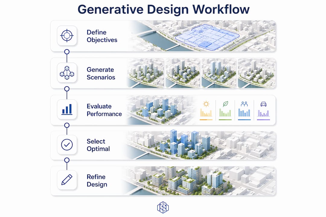
The most effective generative urban design frameworks do not hand the entire design process to an algorithm. They use a structured, staged workflow in which AI generates options and humans guide, review, and refine at each stage. Stepwise workflows outperform end-to-end generation models in quality and regulatory adherence, as demonstrated across cities including Chicago and New York.
A typical staged workflow proceeds as follows:
- Road network and land use planning. The planner defines site boundaries, connectivity requirements, and zoning constraints. The generative model produces candidate street grids and land use distributions for human review and selection.
- Building layout generation. Using the approved street network as a fixed input, the system generates building footprints, heights, and programme mixes. ControlNet diffusion models, guided by text prompts and image constraints, produce high-fidelity layouts at this stage.
- Detailed rendering and performance scoring. Approved layouts are rendered in 3D and scored against sunlight, heat, cost, and green space metrics. The planner selects preferred scenarios or requests further iterations.
- Human review and compliance check. A qualified planner reviews outputs against local planning policy, building regulations, and site-specific constraints before any scenario is taken forward.
The comparison between end-to-end and stepwise generation is worth examining directly:
| Approach | Human control | Regulatory compliance | Design diversity |
|---|---|---|---|
| End-to-end generation | Low | Variable | High but unfiltered |
| Stepwise staged workflow | High at each stage | Consistently stronger | Controlled and purposeful |
Human-in-the-loop frameworks using multimodal diffusion models preserve professional control and design adaptability across multiple generation stages. This matters because AI does not yet independently produce regulation-compliant planning documents. The planner remains the decision-maker; the algorithm accelerates the options appraisal.
Pro Tip: Treat the road network stage as your most consequential human decision. Street layouts are the hardest element to revise later in the process, and they constrain every subsequent building and open space decision. Invest time in reviewing network options before moving to building layout generation.
What are the benefits and challenges of generative urban design?
The value of generative urban design lies primarily in speed and quantitative rigour. Generative design quantifies trade-offs quickly, enabling objective comparison of scenarios that traditional methods cannot match in terms of pace. For a real estate developer assessing a mixed-use redevelopment site, this means receiving a structured comparison of density versus daylight access, or construction cost versus green space provision, within days rather than months.
Key benefits include:
- Accelerated scenario generation. Hundreds of design options can be produced and scored in the time it would previously take to develop a single scheme manually.
- Quantitative trade-off analysis. Cost, environmental performance, and social metrics are attached to each scenario, supporting evidence-based decision-making at planning committee or board level.
- Improved stakeholder communication. 3D visualisations and performance dashboards make complex planning trade-offs accessible to non-specialist audiences, improving the quality of public consultation and multistakeholder assessment.
- Earlier feasibility insight. Generative tools excel in early-stage feasibility studies, where testing the interaction between density, sunlight, and infrastructure costs informs go or no-go decisions before significant design expenditure.
The challenges are equally real and should not be underestimated:
- Data quality is the primary bottleneck. Poor input data undermines output quality regardless of how sophisticated the generation model is. Accurate site boundaries, current zoning data, and reliable GIS layers are prerequisites, not optional extras.
- AI autonomy has clear limits. Generative AI acts as a supplementary planning tool that accelerates engineering-oriented analysis but does not replace expert judgement on contextual, ethical, or political dimensions of planning.
- Black-box risk. Systems that generate outputs without transparent scoring logic make it difficult for planners to defend decisions to regulators or communities. Structured, auditable workflows are preferable to opaque end-to-end models.
Practical applications and generative design examples in urban planning
Generative urban design tools are already in active use across several planning contexts. The following table illustrates common application types and the outputs they produce:
| Application | Typical inputs | Key outputs |
|---|---|---|
| High-rise mixed-use development | Site boundary, FAR targets, zoning rules | Massing options, daylight scores, cost estimates |
| Masterplanning and redevelopment | GIS data, infrastructure constraints | Street networks, land use distributions, 3D models |
| Early-stage feasibility study | Site area, programme brief, density targets | Scenario comparison reports, green space ratios |
| Public space and greenery planning | Open space targets, accessibility standards | Park layouts, tree canopy maps, heat stress scores |
| Stakeholder communication | Approved scenarios | Rendered 3D visualisations, performance dashboards |
Platforms such as Rhino with Grasshopper have long supported parametric and generative design in architecture, allowing architects to script building form generation directly. For broader urban-scale work, platforms that integrate GIS data, 3D city models, and automated area generation provide the spatial context that building-scale tools lack. 3D Cityplanner, for example, combines automated building and area generation with scenario comparison tools for sunlight, visibility, parking, and development capacity in a browser-based environment, making it accessible without specialist software installation.
The shift to data-driven urban planning is most visible in early feasibility and masterplanning stages, where generative outputs inform site acquisition decisions, planning applications, and design briefs. Outputs typically include georeferenced maps, massing renders, 3D city model exports, and quantitative performance reports that can be shared directly with planning authorities or development partners.
For planners working on urban planning workflows, integrating generative scenario generation at the front end of a project reduces the number of costly design revisions later and provides a defensible evidence base for planning submissions.
Key takeaways
Generative urban design delivers its greatest value when structured workflows combine algorithmic scenario generation with expert human review at each design stage, grounded in high-quality GIS and zoning data.
| Point | Details |
|---|---|
| Core definition | Generative urban design uses algorithms to produce and score multiple urban scenarios simultaneously across cost, daylight, and social metrics. |
| Stepwise workflows win | Staged road network, building layout, and rendering workflows outperform end-to-end generation in compliance and design quality. |
| Data quality is decisive | Accurate site boundaries, GIS layers, and zoning constraints are prerequisites; poor inputs produce unreliable outputs regardless of model sophistication. |
| Human oversight is non-negotiable | AI accelerates options appraisal but does not replace expert judgement on regulatory, contextual, or ethical planning decisions. |
| Early-stage value is highest | Generative tools are most effective in feasibility studies and masterplanning, where rapid scenario comparison informs go or no-go decisions before significant design spend. |
Generative design is reshaping what it means to be an urban planner
I have watched the planning profession debate whether computational tools would replace planners for the better part of two decades. The honest answer is that generative design does not replace planners. It changes what planners need to be good at.
The craft of urban design, the intuitive feel for how a street should relate to a building line or how a park should sit within a neighbourhood, remains irreplaceable. What generative tools remove is the bottleneck of manual scenario production. When I see a team spend three weeks producing two massing options for a site that a generative system could evaluate in 500 configurations overnight, the inefficiency is not a sign of professional rigour. It is a missed opportunity.
What concerns me more is the tendency to treat generative outputs as conclusions rather than inputs. A system that generates urban form variations across eight performance objectives is producing a map of the possibility space, not a recommendation. The planner’s job is to navigate that map with contextual knowledge, community understanding, and regulatory expertise that no algorithm currently holds.
The future of urban design is one where planners become systems facilitators, setting objectives, interpreting outputs, and making the judgements that data alone cannot make. That is a more demanding role, not a lesser one. Planners who engage with generative tools now, learning their strengths and their limits, will be better positioned to lead that transition than those who wait for the tools to become perfect.
— Anne Dullemond
See generative urban design in action with 3D Cityplanner
3D Cityplanner is a browser-based urban design platform that puts generative scenario creation, 3D visualisation, and performance analysis in a single environment. Urban planners, architects, and real estate developers use it to generate and compare building massing, street layouts, greenery, parking, sunlight, and visibility scenarios without specialist software. The platform draws on GIS data and 3D city models to ground every scenario in real site conditions, making it directly applicable to feasibility studies, masterplanning, and stakeholder presentations. Explore the digital twin capabilities to see how live scenario comparison supports faster, evidence-based planning decisions from the earliest project stage.
FAQ
What is generative urban design in simple terms?
Generative urban design is the use of algorithms and AI models to automatically create and evaluate multiple urban planning scenarios, covering building massing, street layouts, land use, and environmental performance, so planners can compare options quickly and objectively.
How does generative urban design differ from traditional urban planning?
Traditional urban planning produces a small number of manually developed design options. Generative urban design produces hundreds of algorithmically generated scenarios scored against quantitative criteria, enabling trade-off analysis at a scale and speed that manual methods cannot achieve.
What data do you need to start a generative urban design process?
High-quality, structured base data is required, including accurate site boundaries, current zoning constraints, GIS layers, and infrastructure information. Input data quality is the primary factor determining whether generative outputs are reliable and usable.
Can generative design tools produce planning-ready documents?
Generative AI currently acts as a supplementary tool and does not independently produce regulation-compliant planning documents. Expert planners must review, refine, and validate all outputs before they are suitable for formal planning submissions.
What are the most common generative design examples in urban practice?
Common applications include high-rise mixed-use massing studies, masterplanning for redevelopment sites, early-stage feasibility comparisons, and public space layout optimisation. Outputs typically include 3D visualisations, georeferenced maps, and quantitative performance reports covering daylight, cost, and green space metrics.