The role of open data in city planning: 2026 guide
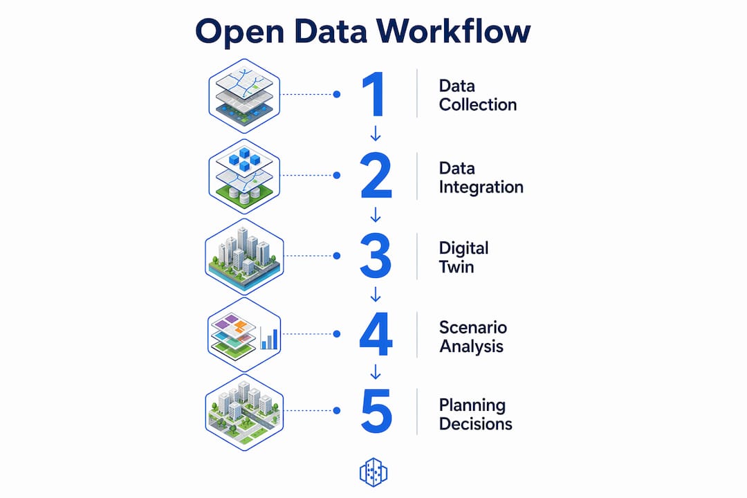
Open data in city planning is defined as publicly accessible, machine-readable information that enables transparent, evidence-based urban development decisions. Datasets covering cadastral boundaries, land use, building footprints, mobility flows, and environmental conditions form the backbone of modern planning practice. Platforms such as urban digital twins and 3D Cityplanner depend on this data to model, analyse, and compare spatial scenarios with confidence. The role of open data in city planning has shifted from a transparency aspiration to a technical prerequisite for any credible planning workflow.
What types of open data drive city planning?
Open data in urban planning spans several distinct dataset categories, each serving a specific function in the development process. Understanding which datasets apply to which decisions is the first step towards building a reliable data strategy.
The most commonly used categories include:
- Cadastral and land use data: Property boundaries, ownership records, and zoning classifications underpin site evaluation, development capacity analysis, and land assembly decisions.
- Building and infrastructure datasets: 3D building footprints, floor counts, and road network geometry support urban form modelling, massing studies, and infrastructure load assessments.
- Mobility and transport data: Pedestrian counts, public transport routes, cycling infrastructure, and traffic volumes inform accessibility analysis and sustainable mobility planning.
- Environmental and climate data: Air quality indices, noise contours, flood risk zones, and urban heat island maps support resilience planning and green infrastructure decisions.
- Greenery and public space data: Tree canopy coverage, park boundaries, and open space classifications feed directly into livability assessments and biodiversity net gain calculations.
EU cities have demonstrated the value of combining these layers. Integrated monitoring of air quality, traffic, noise, and crowd movement enables real-time risk assessment and climate adaptation, including heatwave management via public temperature and humidity maps. That shift from reactive incident response to proactive risk prevention is only possible when datasets are unified and openly accessible.
Pro Tip: Prioritise datasets published in machine-readable, standardised formats such as GeoJSON, CityGML, or OGC-compliant APIs. Proprietary formats create integration bottlenecks that slow down scenario modelling and limit cross-departmental collaboration.

How does open data power urban digital twins?
An urban digital twin is a data-driven virtual replica of a city or district, updated continuously to reflect real-world conditions. Open data is not simply an input to these systems. It is their structural foundation.
Open data ensures traceability and auditability of decisions by linking outcomes directly to underlying datasets, models, and assumptions. Without it, digital twin outputs become opaque. Institutions and citizens cannot verify how a planning recommendation was reached, which undermines trust in the entire process.
The Bologna pilot project illustrates this concretely. A rapid prototyping framework for urban digital twins used open data and open-source tools to automate baseline data acquisition and mobility network analysis. The result was a reproducible, extensible prototype that planning teams could interrogate, share, and build upon without proprietary dependencies.
The table below summarises how specific open data features translate into planning outputs within a digital twin environment:
| Open Data Feature | Planning Output |
|---|---|
| Standardised building geometry (CityGML) | Accurate massing, shadow, and visibility analysis |
| Open cadastral boundaries | Defensible zoning and development capacity calculations |
| Real-time mobility feeds | Dynamic accessibility and transport impact modelling |
| Environmental sensor data | Climate resilience scenario testing |
| Open land use classifications | Cross-departmental scenario comparison and reproducibility |
Interoperability and standardised access must be built into scenario planning design from the outset, not retrofitted later. This is the difference between a digital twin that one team can use once and a platform that multiple departments can extend over years.
You can explore how urban digital twins translate open data into live planning environments in practice.
What are the benefits and challenges of open data in planning?
Open data delivers measurable advantages across the planning lifecycle. It also introduces governance demands that many organisations underestimate.
Key benefits include:
- Transparency and accountability: Open data lowers barriers to information discovery and reuse, supporting evidence-based policy and accountability across infrastructure and service sectors. Decisions become auditable rather than opaque.
- Faster decision-making: When datasets are pre-standardised and openly accessible, planners spend less time sourcing and cleaning data and more time on analysis and scenario comparison.
- Community engagement: Open data enables residents, civic organisations, and developers to interrogate planning proposals independently. This shifts public consultation from passive presentation to active participation.
- Cross-sector coordination: Shared datasets reduce duplication between transport, environment, housing, and utilities departments, enabling genuinely integrated planning.
The challenges are equally real. Data governance, including the determination of semantics, geometry correctness, and access methods, is critical to producing defensible outputs from open data tools. Without it, technically functional maps may generate unreliable or unverifiable analyses. That is a serious liability in a planning context where decisions affect built environments for decades.
Helsinki’s open-data-by-default model demonstrates what good governance looks like in practice. Transparency and participation thrive when governance includes clear standards, reducing paralysis and enabling machine-readable datasets for broader use. The result is ecosystem trust that accelerates analysis across the city’s planning teams.
Provenance and integrity mechanisms are equally critical. When data passes through multiple transformations, metadata lineage and trust frameworks allow planners to verify that the information they are using remains fit for purpose.
Pro Tip: Treat data governance as a prerequisite, not an afterthought. Define semantic standards, geometry validation rules, and access protocols before integrating open datasets into any planning tool or digital twin workflow.
How to implement open data strategies for planners
Effective implementation requires a structured approach that addresses data quality, interoperability, and workflow integration from the start. The following steps provide a practical framework for urban planners and city officials.
- Audit your current data sources. Identify which datasets your team already uses, their formats, update frequencies, and licensing terms. Map gaps against the dataset categories listed above.
- Prioritise open, standardised formats. Source cadastral, building, and environmental data from national or municipal open data portals in OGC-compliant or GeoJSON formats. Avoid datasets locked in proprietary systems where alternatives exist.
- Establish provenance tracking from day one. Document the origin, transformation history, and version of every dataset entering your workflow. The OGC Trusted Data Systems Testbed framework provides a practical reference for implementing metadata lineage and integrity verification.
- Integrate datasets into a scenario planning environment. Load validated open data into a platform capable of 3D modelling, zoning analysis, and scenario comparison. 3D Cityplanner, for example, combines GIS data and 3D city models with automated area generation to support feasibility studies and masterplanning directly in the browser.
- Design for interoperability across departments. Use standardised workflows and shared data schemas so that transport, environment, and housing teams can access and contribute to the same planning environment. This is what separates a one-off analysis from a sustainable planning infrastructure.
- Communicate scenarios to stakeholders using visual outputs. Open data gains its full value when translated into 3D visualisations, comparison tables, and impact assessments that non-technical stakeholders can engage with. Scenario transparency builds public trust and accelerates approval processes.
The World Bank confirms that open data facilitates accountability and improves cross-sector coordination in infrastructure and service delivery. That coordination only materialises when implementation is deliberate and governed.
Key takeaways
Open data is the foundational layer of credible urban planning, and its value depends entirely on governance, standardisation, and deliberate integration into planning workflows.
| Point | Details |
|---|---|
| Open data underpins digital twins | Traceability and auditability of planning decisions require open, standardised datasets as their foundation. |
| Governance is non-negotiable | Semantic clarity, geometry validation, and provenance tracking must be defined before data enters any planning tool. |
| Helsinki and Bologna show the way | Both cities demonstrate that open-data-by-default models accelerate analysis and build institutional trust. |
| Interoperability enables collaboration | Standardised formats and shared schemas allow transport, environment, and housing teams to work from the same data. |
| Scenario transparency builds trust | Translating open data into 3D visualisations and comparison outputs makes planning decisions legible to all stakeholders. |
Open data is only as good as the systems around it
I have worked with planning teams that treated open data as a solved problem the moment they published a dataset portal. The data was there, technically accessible, and technically machine-readable. Yet two years later, the same teams were still making decisions based on spreadsheets and gut instinct, because no one had built the governance layer that would make the data usable in practice.
The uncomfortable truth about open data in urban planning is that the data itself is rarely the bottleneck. The bottleneck is almost always the absence of agreed semantics, consistent geometry standards, and clear ownership of data quality. A building footprint dataset with inconsistent floor count attribution is not a planning asset. It is a liability dressed up as transparency.
What I find genuinely encouraging is the direction of travel. The Bologna digital twin prototype shows that reproducible, extensible planning environments can be built quickly when open data and open standards are treated as design constraints from the start. Helsinki shows that governance models do not need to be bureaucratic obstacles. They can be the mechanism that makes broad participation possible.
My practical advice is to start with provenance. Before you integrate any open dataset into a scenario planning workflow, document where it came from, when it was last validated, and what transformations it has undergone. That discipline, applied consistently, is what separates planning tools that produce defensible outputs from those that produce impressive visualisations with uncertain foundations.
— Anne Dullemond
Put open data to work in your planning workflows
3D Cityplanner is a browser-based urban design platform that connects directly to open GIS data sources, enabling planners, municipalities, and developers to build 3D scenario models without specialist software or lengthy data preparation. You can load cadastral boundaries, building footprints, land use classifications, and environmental layers directly into the platform, then design, analyse, and compare development scenarios in 3D. The platform supports feasibility studies, masterplanning, redevelopment analysis, and stakeholder communication, all grounded in the open datasets your team already has access to. Explore how 3D Cityplanner can turn your open data into credible, communicable planning decisions.
FAQ
What is open data in the context of city planning?
Open data in city planning refers to publicly accessible, machine-readable datasets covering land use, cadastral boundaries, buildings, infrastructure, mobility, and environmental conditions. These datasets are freely available for reuse and form the evidence base for transparent, evidence-driven urban development decisions.
How does open data support urban digital twins?
Open data provides the structural foundation for urban digital twins by ensuring that planning decisions are traceable and auditable. Without open, standardised datasets, digital twin outputs cannot be independently verified by institutions or citizens.
What are the biggest challenges of using open data in planning?
The primary challenges are data governance, provenance tracking, and standardisation. Technically accessible datasets can still produce unreliable planning outputs if semantic definitions, geometry standards, and access protocols are not clearly defined and maintained.
Which cities are leading examples of open data in urban planning?
Helsinki operates an open-data-by-default planning model that combines clear governance standards with machine-readable datasets, accelerating analysis and building ecosystem trust. Bologna has demonstrated rapid urban digital twin prototyping using open data and open-source tools, producing reproducible and extensible planning environments.
What formats should planners prioritise for open data integration?
Planners should prioritise OGC-compliant formats such as GeoJSON, CityGML, and WFS/WMS APIs. These formats support interoperability across GIS platforms, digital twin environments, and scenario planning tools, reducing integration effort and enabling cross-departmental collaboration.
Recommended
- Your step-by-step guide to urban development guidelines 2026 – 3D Urban Development
- The role of GIS in urban planning: 2026 guide – 3D Urban Development
- Future of City Planning 2026: Shaping Sustainable Urban Spaces – 3D Urban Development
- The role of collaboration in city planning: 2026 guide – 3D Urban Development