The role of GIS in urban planning: 2026 guide

Most urban planners understand that GIS produces maps. Far fewer recognise that the role of GIS in urban planning has shifted decisively from cartography to strategic decision-support. Today, GIS integrates spatial data from dozens of sources simultaneously, models future scenarios, and communicates complex planning proposals to communities who previously had no way to engage with them. The GIS market is projected to grow from US$15.42 billion in 2025 to US$44.23 billion by 2034, driven largely by smart city and urban planning adoption. This guide unpacks what that means for your practice.
How GIS works in urban planning today
Understanding GIS in city planning begins with its architecture. A geographic information system combines spatial data layers, relational databases, and analytical tools into a single platform where every piece of information is anchored to a real-world location. Early GIS systems in the 1970s and 1980s produced static paper maps. Contemporary platforms do considerably more.
GIS software tools like QGIS and proprietary planning platforms now support spatial queries, predictive modelling, 3D visualisation, and real-time data integration within a single workflow. The core components that make this possible include:
- Spatial data layers: Land use, zoning, topography, infrastructure, and demographic data stacked and cross-referenced
- Attribute databases: Non-spatial information linked to geographic features, such as building age, ownership, or flood risk scores
- Analytical engines: Tools for overlay analysis, network routing, proximity calculations, and statistical modelling
- Visualisation outputs: 2D maps, 3D city models, scenario comparisons, and public-facing interactive displays
The most significant recent shift is the emergence of GeoAI. GeoAI automates data processing, scales spatial analysis across entire city regions, and supports faster, more accurate decision-making than traditional geospatial methods allow. For GIS analysts, this represents not a replacement of existing skills but a substantial extension of analytical capacity.
Core GIS applications in city planning
The practical value of GIS becomes clear when you trace it through specific planning functions. Here are the primary domains where GIS applications in city planning deliver measurable results.
- Land use and zoning analysis. GIS layers parcel boundaries, current use classifications, ownership data, and zoning designations onto a single canvas. Planners can run overlay analyses to identify conflicts between proposed developments and existing zoning, or model the downstream effects of rezoning decisions before a single consultation begins.
- Environmental and climate impact assessments. Mapping flood zones, tree canopy, transit access, and demographic data together gives planners a genuinely comprehensive picture of urban vulnerability. Heat island mapping, green corridor identification, and catchment modelling are all standard GIS outputs that directly inform climate-resilient design decisions.
- Transportation and mobility planning. GIS layers traffic counts, pedestrian infrastructure gaps, and public transport service levels to surface exactly where mobility networks are failing. A planner assessing a proposed residential development can model the pressure that new residents will place on surrounding road and transit capacity before any approval is granted.
- Infrastructure assessment. Spatial databases built within GIS track the condition, age, and capacity of utilities, roads, drainage systems, and public facilities across entire city regions. This turns reactive maintenance into scheduled, evidence-based asset management.
- Community engagement and public consultation. Interactive dynamic maps display zoning updates and project timelines in ways that non-specialists can understand and respond to. This is not a cosmetic improvement. It fundamentally changes the quality of public input that planners receive.
Pro Tip: When using GIS for public consultation, publish interactive maps at least four weeks before formal consultation closes. Communities need time to explore spatial data before they can formulate meaningful feedback.
Advanced data sources powering GIS analysis
The quality of GIS outputs depends entirely on the quality of data feeding the system. Several advanced data sources are reshaping what GIS can reveal about urban environments.
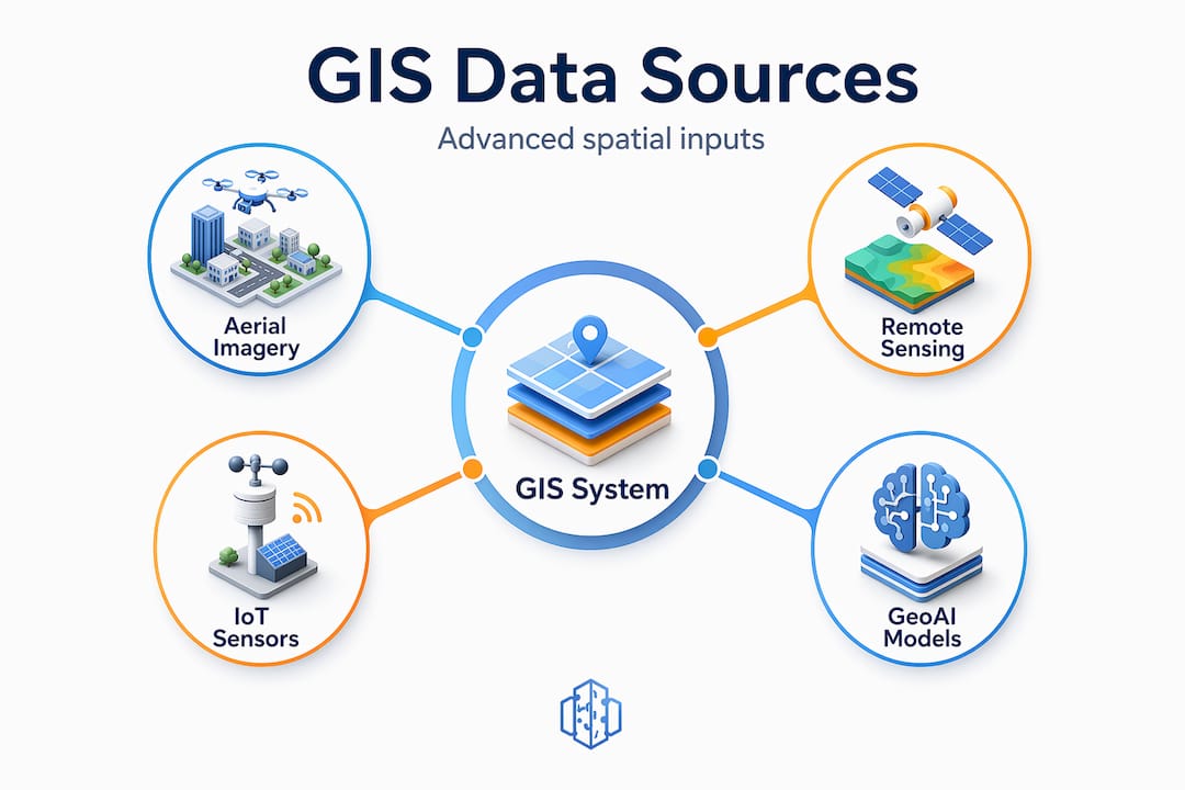
Aerial imagery: oblique and orthogonal
High-resolution oblique aerial imagery captures details that flat maps cannot show. Imagery with ground sample distance down to one inch reveals fences, outbuildings, and drainage patterns that would otherwise require costly site visits to document. Orthogonal and oblique imagery combined provide complete property intelligence, allowing planners to assess building conditions, measure infrastructure dimensions, and track urban change over time without leaving the office.

Remote sensing, IoT, and GeoAI
Real-time sensor networks embedded in city infrastructure generate continuous spatial data streams. When fed into GIS platforms, these streams allow planners to monitor air quality, pedestrian density, and traffic flow as live layers rather than historical snapshots. GeoAI then processes this volume of data at a scale that no analyst team could manage manually.
The table below summarises the main advanced data types and their planning applications:
| Data type | Source | Key planning use |
|---|---|---|
| Oblique aerial imagery | Aerial survey platforms | Site assessment, building condition |
| LiDAR point clouds | Airborne or drone sensors | Topographic modelling, flood risk |
| IoT sensor feeds | Street-level infrastructure | Real-time mobility, air quality |
| Satellite multispectral | Commercial satellites | Land cover change, heat mapping |
| GeoAI-processed layers | AI models on existing GIS data | Predictive zoning, growth modelling |
“GeoAI and GIS technologies must augment, not replace, community involvement to support inclusive, responsible urban planning.” — UN-Habitat, 2025
3D and 4D GIS models take these data sources further still, enabling dynamic infrastructure visualisation and scenario testing that communicates planning options to stakeholders far more clearly than any flat map could achieve.
Challenges in GIS-driven planning
The benefits of GIS in urban development are well documented. The challenges are less frequently discussed, and that is exactly where many implementation efforts run into difficulty.
- Data quality and interoperability. GIS is only as reliable as the data it contains. Inconsistent coordinate systems, outdated parcel records, and incompatible file formats between municipal departments are common sources of analytical error. Effective GIS integration requires planners to tackle interoperability and data quality as a precondition, not an afterthought.
- Digital equity and access. Interactive GIS tools assume that community members have internet access and digital literacy. Neither assumption holds universally. Planners who rely solely on online consultation risk systematically excluding the communities most affected by planning decisions.
- Ethical use of GeoAI. Automated spatial analysis can reproduce and amplify existing biases in planning data. If historical zoning decisions encoded racial or economic discrimination, a GeoAI model trained on that data will perpetuate those patterns unless the training inputs are critically reviewed.
- Organisational capacity. Smaller planning departments often lack the technical staff to manage GIS infrastructure. Licensing costs, training requirements, and data maintenance burdens can make adoption feel prohibitive.
- Keeping human judgement central. GIS skills are now essential for urban professionals, but spatial analysis does not make decisions. Planners do. The most effective GIS implementations treat the technology as a decision-support layer, not a decision-making system.
Pro Tip: Before procuring any GIS platform, audit your existing data holdings for completeness and consistency. A sound data foundation reduces implementation risk more than any feature list in a software brochure.
Applying GIS insights for better outcomes
Understanding GIS capabilities is one thing. Translating them into planning decisions is another. The following framework helps planning departments move from data collection to actionable spatial strategy.
Integration in stages
UN-Habitat’s 12-step GeoAI integration framework provides a structured pathway from identifying suitable use cases through to deploying and scaling GeoAI tools within planning workflows. The principle applies equally to standard GIS adoption: start with one well-defined analytical task, demonstrate value, and expand from there.
Scenario modelling as a planning tool
GIS excels at scenario comparison. A planning team evaluating two potential locations for a new transit corridor can model both options against population density, environmental sensitivity, infrastructure capacity, and land acquisition complexity simultaneously. The result is not a recommendation. It is a transparent, evidenced comparison that decision-makers and communities can interrogate.
| Approach | Without GIS | With GIS |
|---|---|---|
| Site selection | Sequential, often intuitive | Multi-criteria spatial analysis |
| Impact assessment | Report-based, slow | Dynamic, layered, real-time |
| Stakeholder communication | Static maps, PDFs | Interactive, queryable visualisations |
| Scenario planning | Limited, costly | Rapid, reproducible model runs |
Communicating spatial insights
GIS is central to smart city development, and smart city ambitions require that spatial insights reach audiences beyond technical teams. The most effective planners pair rigorous GIS analysis with purposefully simplified visualisations for political and community audiences. Dashboards, story maps, and animated scenario flyovers all extend the reach of GIS data beyond the analyst’s workstation. You can explore urban planning participation tools that support exactly this kind of accessible public communication.
My perspective on GIS and planning practice
I have followed GIS adoption in urban planning long enough to notice a persistent pattern. Organisations invest in GIS platforms expecting clarity and often encounter complexity first. The data never quite matches what the system needs. The staff who understand the technology are not always the ones making planning decisions. And the communities who should benefit most from better-evidenced planning are frequently the last to see the outputs.
What I have come to believe is that the transformative potential of GIS is real, but it is not automatic. The technology does not improve planning by existing. It improves planning when the people using it understand both its capabilities and its limits. I have seen GIS used to produce beautifully rendered maps that justified decisions already made in private. I have also seen GIS genuinely shift a planning process, opening up options that no one had considered because the spatial evidence made them visible for the first time.
The arrival of GeoAI raises the stakes on both sides. The analytical power is genuinely extraordinary. The risk of that power being used to shortcut community engagement or mask flawed assumptions in algorithmic complexity is equally real. My view is that the planners who will get the most from GIS in the coming decade are not necessarily those with the most advanced technical skills. They are those who combine spatial literacy with a genuine commitment to inclusive, evidence-led practice.
The future of urban planning belongs to those who can hold both of those things at once.
— Anne
Take your GIS practice further with 3dcityplanner
If this article has clarified the strategic value of GIS in city planning, the logical next step is exploring a platform built to put those capabilities into practice.
3dcityplanner integrates GIS data with advanced 3D and 4D urban modelling tools, giving planning professionals a single environment for spatial analysis, scenario visualisation, infrastructure simulation, and stakeholder communication. The platform supports automatic building generation, line-of-sight visualisation, noise impact simulation, and real-time project timeline management. Whether you are working on a zoning review, a transport corridor assessment, or a large-scale masterplan, the 3dcityplanner platform connects your GIS data to the visualisation and collaboration tools your team actually needs. Start with a free trial and see how spatial intelligence translates into better planning decisions.
FAQ
What is GIS in city planning?
GIS in city planning is a technology platform that combines spatial data, mapping tools, and analytical functions to support evidence-based decisions about land use, infrastructure, environment, and community services. It integrates multiple data layers to give planners a comprehensive view of how urban systems interact.
Why use GIS for urban development?
GIS enables planners to analyse complex spatial relationships across land use, transport, environment, and demographics simultaneously, producing insights that sequential or report-based approaches cannot match. It also supports scenario modelling, which allows teams to compare options before committing resources.
What are the main GIS applications in city planning?
Core applications include land use and zoning analysis, environmental impact assessment, transportation network planning, infrastructure asset management, and community engagement through interactive mapping tools.
How does GIS aid urban design?
GIS supports urban design by providing accurate spatial context, from topography and sun angles to pedestrian movement patterns and existing building footprints, that designers can use to test proposals against real-world conditions before detailed design work begins.
What is GeoAI and how does it relate to GIS?
GeoAI combines artificial intelligence with geographic information systems to automate spatial data processing, identify patterns across large datasets, and generate predictive models for urban growth, climate risk, and infrastructure demand. According to UN-Habitat’s 2025 framework, effective GeoAI adoption follows a structured, people-centred integration process rather than purely technical deployment.