Benefits of 3D city models for urban planners
Urban planning has never been more complex. Growing populations, climate pressures, and competing stakeholder demands mean that the consequences of poor spatial decisions are felt for decades. The benefits of 3D city models address these challenges directly, offering planners, architects, and developers a shared, data-rich environment that flat maps and 2D drawings simply cannot provide. This article covers the most significant advantages you gain when adopting 3D city modelling, from stakeholder communication to measurable cost reductions and sustainability analysis.
1. Benefits of 3D city models for stakeholder engagement
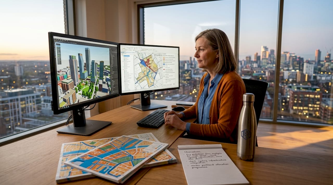
One of the most immediate advantages of 3D city modelling is what it does for communication. When a planning committee, a community group, or a private developer looks at a two-dimensional site plan, they are interpreting an abstraction. When they look at a photorealistic, interactive 3D model of the same area, they see what will actually be built, and what it will displace.

High-fidelity 3D representations remove ambiguity in ways that drawings never can. They allow participants in the planning process to assess scale, massing, solar shadow, and street-level impact without specialist training. This matters in public consultations especially, where misunderstandings often escalate into costly objections and appeals.
The role of 3D models in facilitating dialogue between planners, architects, and developers is well documented, but the real advantage is speed. Design modifications can be made in real time during a meeting, letting all parties explore alternatives rather than waiting for revised drawings.
Key engagement benefits include:
- Shared visual reference that reduces misinterpretation across disciplines
- Real-time scenario testing during workshops and public consultations
- Clearer documentation of agreed design changes, reducing disputes later
- Improved buy-in from non-technical stakeholders who can genuinely evaluate proposals
Pro Tip: When running stakeholder workshops, load your 3D model on a large display with free-orbit navigation. Allowing participants to physically rotate and zoom the model themselves produces far more productive feedback than a guided presentation.
2. Real-time data integration and digital twin capabilities
A static 3D model is useful. A 3D model connected to live data streams is something categorically different. Experts stress that 3D models with real-time data function as living digital twins rather than simple visualisations. The distinction matters enormously for operational decision-making.
When IoT sensors, traffic counters, environmental monitors, and infrastructure management systems feed data into your urban model, the model stops representing what the city looked like when it was surveyed. It represents what the city is doing right now.
“Digital twins enable simulation of changes to urban infrastructure before actual implementation, identifying bottlenecks and unintended consequences before a single metre of road is altered.” (Digital Twin for Urban Planning)
The practical applications for planners are significant:
- Simulate traffic redistribution following a road closure before approving the scheme
- Model the thermal performance of a proposed building cluster under different seasonal conditions
- Track infrastructure degradation rates and predict maintenance windows
- Test flood response scenarios by feeding rainfall data into drainage models
Platforms such as 3dcityplanner’s digital twin tools provide this kind of integrated, dynamic modelling environment without requiring teams to stitch together separate GIS and simulation applications.
3. Measurable cost savings and risk reduction
The financial case for 3D city modelling is no longer speculative. Research shows that advanced digital twin implementation reduces lifecycle costs by up to 25% and cuts operational risk exposure by approximately 30%. These are not marginal gains. On a major infrastructure project with a budget in the hundreds of millions, a 25% lifecycle cost reduction translates to transformative savings.
The mechanism is straightforward. When you can simulate the construction sequence, test structural performance, and identify clashes between building systems before breaking ground, you avoid the rework that accounts for a disproportionate share of construction cost overruns. Equally, when operational teams can model infrastructure performance rather than reacting to failures, maintenance costs fall and asset lifespans extend.
| Benefit area | Reported improvement |
|---|---|
| Lifecycle cost reduction | Up to 25% |
| Operational risk exposure | Reduced by ~30% |
| Production time (industrial digital twins) | 24.4% reduction |
| Energy savings (operational phase) | Up to 23% |
Pro Tip: Present cost reduction data to finance stakeholders early in the procurement process. The upfront investment in 3D modelling is often scrutinised without reference to the savings it generates across the full project lifecycle. Framing the conversation around total cost of ownership shifts the discussion entirely.
4. Advances in data management: CityJSON and format optimisation
The technical foundations of 3D city modelling have matured considerably. One of the most practical improvements for planners and developers working at city scale is the CityJSON format, which delivers roughly 6x file compression compared to traditional CityGML. That compression is not merely a storage convenience. It translates directly into faster loading, simpler data pipelines, and more accessible sharing across project teams.
Practitioners now routinely convert CityGML datasets into runtime-optimised formats such as 3D Tiles. This process preserves semantic metadata while enabling high-performance streaming and rendering, meaning you retain the rich attribute data attached to each building or infrastructure element while making the model responsive enough for real-time navigation.
For urban planning teams, the implications are practical:
| Format | Key characteristic | Benefit for planners |
|---|---|---|
| CityGML | Semantically rich, large file size | Authoritative data source |
| CityJSON | 6x compression vs GML | Fast sharing and processing |
| 3D Tiles | Runtime-optimised streaming | Real-time web-based collaboration |
Understanding 3D city modelling software options means knowing which format serves each stage of your workflow. Data collection and archiving favours CityGML. Live collaboration and stakeholder presentations favour 3D Tiles or CityJSON.
5. Sustainability and environmental planning
The advantages of 3D city modeling extend directly into environmental planning, an area where the quality of analysis can determine whether a development meets regulatory standards or stalls at the consent stage. Research confirms that 3D city models support solar exposure analysis, noise level estimation, and broader environmental monitoring, all within the same spatial dataset.
Solar potential analysis is a strong example. A 3D urban model can calculate annual irradiation across every roof surface in a neighbourhood, identifying which buildings are viable candidates for photovoltaic installations and which are shaded by adjacent structures. This analysis, which once required specialist consultants and months of work, can now be run as a layer within the planning model.
Noise propagation modelling follows the same logic. Rather than assessing ground-level noise in isolation, a 3D model captures vertical sound distribution across building facades, which is critical for mixed-use developments in dense urban areas. Similarly, green space optimisation within a 3D model allows planners to assess the cooling effect of tree canopy cover, the permeability of surfaces, and the cumulative environmental impact of design choices before planning permission is sought.
Key sustainability applications include:
- Solar irradiation mapping across roof surfaces and facades
- Noise propagation modelling, both horizontal and vertical
- Urban heat island analysis using surface temperature data
- Green infrastructure optimisation for drainage and biodiversity
- Carbon impact assessment across different design scenarios
6. Improved accuracy in infrastructure and construction planning
Two-dimensional plans have a fundamental problem in complex urban environments: they cannot adequately represent the vertical relationships between utilities, structures, and ground conditions. A 3D city model holds all of these layers simultaneously, which changes the quality of decisions made during infrastructure planning.
Clash detection is the most immediate gain. When water mains, cable ducts, structural foundations, and transport infrastructure all appear in the same georeferenced 3D environment, conflicts between them are visible before construction begins rather than during it. The cost of resolving a clash on screen is a small fraction of the cost of resolving it on site.
Learning how to create 3D city models for infrastructure projects also reveals an underappreciated benefit: the model serves as a single source of truth across the project lifecycle. Design teams, contractors, asset managers, and emergency services can all access the same spatial data, updated to reflect construction progress and operational changes.
7. Support for 4D planning and phased development
The benefits of 3D city planning extend further when time is added as a dimension. 4D modelling attaches project timelines to spatial data, allowing teams to see not just what will be built, but when each component will be constructed, commissioned, and occupied.
For large mixed-use developments or city-wide regeneration programmes, this capability resolves one of the most persistent coordination problems: sequencing. Which phases depend on which infrastructure? When will disruption to existing residents peak? Where are the critical path dependencies that could delay the entire project?
4D models answer these questions visually and interactively. Project managers can adjust the timeline and watch the construction sequence update in real time, testing different phasing strategies without reworking a Gantt chart. Stakeholders who would never engage with a programme schedule will readily engage with an animated 3D construction sequence.
My perspective on adopting 3D city modelling
I have seen many planning teams approach 3D modelling as an all-or-nothing decision, believing they must either model an entire city at high resolution or not bother. That framing is wrong, and it holds capable teams back.
Scalable adoption strategies starting with low-resolution meshes across a wide area, supplemented by precise drone captures in critical zones, reduce initial investment while still delivering genuine analytical value. In my experience, the teams that get the most from 3D modelling are those who start focused, iterate fast, and expand scope only when they have proven the value to their organisation.
I also think the industry underestimates how much of the challenge is organisational rather than technical. The software capabilities now available, including those on the 3dcityplanner platform, have moved far ahead of most organisations’ readiness to use them. Data governance, cross-department collaboration, and clear ownership of the model are often the bottlenecks, not the technology itself.
Digital twins complement human expertise. They do not replace the judgement of an experienced urban planner. The best outcomes come from teams who treat the model as a tool for testing their thinking, not as an oracle that produces answers.
— Anne
Explore 3dcityplanner’s full feature set
The benefits discussed in this article are not theoretical. 3dcityplanner brings them together in a single platform built specifically for urban planning professionals, architects, and developers.
From automatic building generation and line-of-sight visualisations to noise simulation, solar analysis, and 4D timeline planning, the platform covers the complete spectrum of advantages that 3D city modelling offers. Teams can collaborate in real time, import existing 3D datasets, and present findings to stakeholders in a format that genuinely communicates spatial complexity. You can explore the complete feature list to see exactly how each capability maps to the planning challenges your projects face. A trial period is available without upfront payment, so you can assess the platform against your own project data before committing.
FAQ
What are the main benefits of 3D city models?
The primary benefits include improved stakeholder communication through realistic visualisation, real-time data integration via digital twin capabilities, lifecycle cost reductions of up to 25%, and enhanced sustainability analysis covering solar exposure, noise, and environmental impact.
Why use 3D urban models instead of traditional 2D plans?
3D urban models remove the ambiguity inherent in two-dimensional drawings, allow clash detection between infrastructure layers, support real-time scenario testing, and provide a single shared spatial dataset accessible to all project stakeholders throughout the project lifecycle.
How do 3D city models support sustainable planning?
Research confirms that 3D models enable solar irradiation mapping, vertical noise propagation modelling, urban heat island analysis, and green infrastructure optimisation. These capabilities allow planners to assess environmental performance of design decisions before planning consent is sought.
What is the difference between a 3D city model and a digital twin?
A 3D city model is a spatial representation of the built environment. A digital twin connects that model to live data streams from IoT sensors and operational systems, making it a dynamic simulation environment rather than a static snapshot.
How does CityJSON improve 3D city model workflows?
CityJSON delivers approximately 6x file compression compared to CityGML, significantly reducing processing time and simplifying data sharing across project teams without sacrificing the semantic attribute data attached to urban features.
Recommended
- Why Use 3D City Models in Urban Projects – 3D Urban Development
- How to Create 3D City Models for Urban Planning Projects – 3D Urban Development
- The role of 3D models in architecture and urban planning – 3D Urban Development
- 3D City Modeling Software: The Ultimate Guide for Urban Planners & Developers - 3D Gebiedsontwikkeling