Sustainable city planning guide for professionals

Sustainable city planning is the deliberate process of designing urban environments that balance environmental resilience, social equity, and economic vitality to create healthy, livable cities for present and future generations. This guide draws on the World Bank’s Restrict–Condition–Promote (RCP) framework, Larco and Knudson’s Sustainable Urban Design Handbook, ICLEI’s review of 1,444 climate action plans, and Tacoma’s 2030 Climate Action Plan to give urban planners, architects, policymakers, and community activists a structured, evidence-based path from ambition to implementation. Whether you are setting targets for the first time or refining an existing strategy, the frameworks and steps here are grounded in 2026 research and real-world practice.
What core principles underpin a sustainable city planning guide?
Sustainable urban development rests on three interdependent outcomes: environmental resilience, social equity, and economic vitality. Remove any one of these and the plan becomes fragile. A city that achieves net-zero emissions but excludes lower-income residents from green spaces has not achieved sustainability. A city that builds flood defences without addressing housing affordability will face social instability long before the next storm arrives.

The Larco and Knudson framework organises over 50 sustainability elements across five topics and four project scales, giving planners a structured way to manage complexity without drowning in options. This matters because information overload is one of the most underacknowledged barriers in urban planning practice. The framework indexes each element by difficulty and importance, which means you can filter for what is site-appropriate and achievable within your governance context rather than chasing every best practice simultaneously.
Before any planning process begins, three prerequisites must be in place.
| Prerequisite | What it involves | Key tool or framework |
|---|---|---|
| Hazard and climate risk data | Flood maps, heat stress models, seismic assessments | World Bank RCP framework |
| Stakeholder engagement structures | Defined roles for government, private sector, and community | ICLEI climate action plan templates |
| Governance and enforcement capacity | Zoning authority, permitting systems, monitoring mandates | IN-PLAN spatial planning roadmap |
Without hazard data, risk-informed zoning is guesswork. Without stakeholder structures, plans stall at the consultation stage. Without governance capacity, even well-designed policies fail at implementation. Treat these three as non-negotiable starting conditions, not aspirational additions.
How can planners integrate climate risk into sustainable urban planning steps?
Risk integration is the step most frequently treated as an afterthought, and that is precisely why so many urban plans fail to survive contact with permitting systems and capital budgets. The World Bank’s RCP approach provides a practical structure: Restrict unsafe developments in high-hazard zones, Condition allowable projects with risk studies and mitigation requirements, and Promote growth in safer areas using incentives and nature-based solutions.
Cities that have applied this logic demonstrate measurable results. Hong Kong uses risk-conditioned slope development regulations to manage landslide exposure across steep terrain. Guangzhou has embedded flood risk zoning into its master plan, directing commercial investment away from inundation-prone districts. Beira, Mozambique, rebuilt its coastal planning framework after Cyclone Idai using a restrict-and-promote logic that channels new housing to higher ground while restoring mangroves as natural buffers.
ICLEI’s review of 1,444 climate action plans reveals that many cities are already planning for warming scenarios above 1.5°C. This is not pessimism. It is the operationally honest position, because adaptation planning calibrated only to the most optimistic warming trajectory leaves cities exposed when conditions exceed that threshold.
Key steps for embedding risk into your planning process:
- Collect hazard data at the neighbourhood scale, not just city-wide averages
- Map each hazard layer against existing land-use designations to identify conflicts
- Apply RCP logic to zoning codes: restrict, condition, or promote based on risk level
- Back-map every proposed measure to a specific risk-reduction goal so it survives budget scrutiny
- Update risk assessments on a defined cycle, not only after disaster events
Pro Tip: Connect your hazard data directly to enforceable zoning instruments from the outset. Risk assessments that sit in reports but never reach the planning code are the single most common reason resilience strategies fail to deliver on the ground.
What step-by-step process supports sustainable urban growth from plan to delivery?
Phased implementation is what separates a credible sustainability plan from a vision document. Tacoma’s 2030 Climate Action Plan is one of the clearest examples of sequencing done well. The city ran a 14-month community engagement process with over 1,000 participants before setting targets, then structured delivery in three-year implementation cycles with annual progress reporting to both council and the public. The plan includes over 20 targets for 2030 and requires $2.5 billion in investment. That scale of commitment only becomes politically and financially viable when the engagement foundation is solid.
The World Economic Forum identifies systems thinking and stakeholder alignment as the critical factors in turning climate strategies into bankable, deliverable projects. The European Bank for Reconstruction and Development’s Green City Action Plan model operationalises this through 15-year horizon planning that incorporates vision, strategic goals, prioritised actions, and monitoring frameworks co-created with stakeholders.
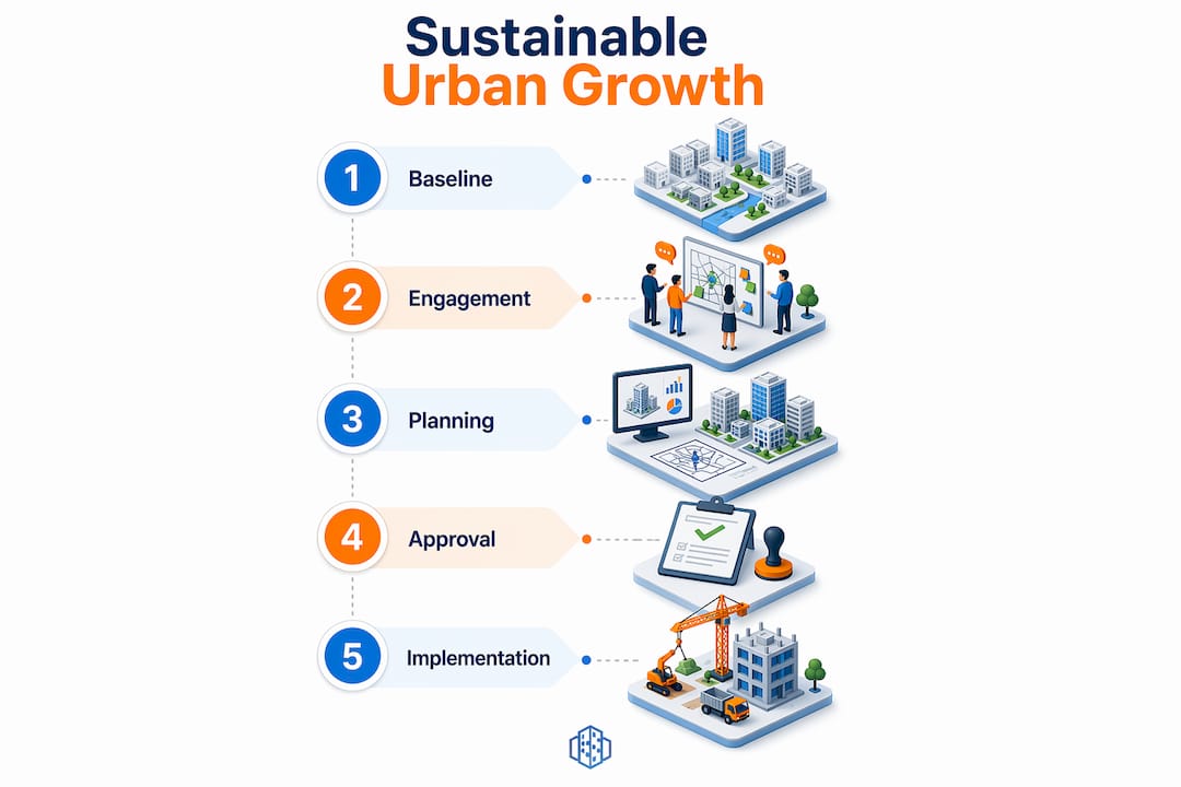
A practical phased approach follows this sequence:
- Baseline assessment. Collect environmental, social, and economic data. Identify key risks and opportunities at the neighbourhood scale.
- Stakeholder engagement. Run structured consultation with government departments, private investors, community groups, and technical experts. Define shared goals.
- Target setting. Establish measurable, time-bound targets aligned to national and international commitments. Use the engagement findings to ground targets in local reality.
- Project pipeline development. Identify and prioritise specific projects using systems thinking. Assess co-benefits, costs, and implementation feasibility for each.
- Financing and procurement. Match projects to funding sources: public budgets, green bonds, development finance, and private investment.
- Implementation in cycles. Deliver in three-year cycles with defined milestones. Adjust based on annual monitoring data.
- Reporting and iteration. Publish progress reports. Use findings to update the next cycle’s priorities and targets.
| Phase | Key deliverable | Typical timeframe |
|---|---|---|
| Baseline and engagement | Risk and opportunity report, stakeholder map | 6 to 14 months |
| Target setting and pipeline | Prioritised project list with cost estimates | 3 to 6 months |
| First implementation cycle | Delivered projects, monitoring dashboard | 3 years |
| Review and iteration | Updated plan, revised targets | Ongoing, annual |
The three-year cycle structure matters because it creates visible progress within political terms, maintains community trust, and allows strategies to adapt as climate conditions and local priorities evolve.
How does cross-sector collaboration improve sustainable city planning outcomes?
No single department or organisation holds all the levers required for sustainable urban development. Effective green city planning depends on aligning government planning departments, infrastructure agencies, private developers, financial institutions, and community representatives around a shared framework. When these actors operate in silos, projects stall, funding gaps appear, and communities disengage.
Collaborative urban planning tools and platforms play a significant role in reducing these barriers. Digital environments that allow multiple stakeholders to view, annotate, and respond to the same spatial data in real time reduce the friction of cross-departmental decision-making. They also create a shared record of decisions, which is particularly valuable when projects span multiple political cycles.
The benefits of structured collaboration include:
- Reduced duplication of effort across departments and agencies
- Earlier identification of conflicts between infrastructure, land-use, and environmental goals
- Greater community ownership of outcomes, which reduces opposition during implementation
- Improved access to private and development finance, as co-created plans carry more credibility with investors
Pro Tip: Use iterative engagement cycles rather than single consultation events. Returning to the same stakeholder groups with updated proposals and progress data builds transparency and trust over time, which is far more effective than a one-off workshop at the start of a project.
What are the most common barriers in sustainable city planning and how do you address them?
Even well-designed plans encounter predictable obstacles. Recognising these barriers early gives you the opportunity to build mitigation strategies into the plan from the start rather than responding reactively.
The IN-PLAN project, a 3.5-year collaboration with lighthouse and pilot authorities across Europe, found that capacity transfer through train-the-trainer programmes was the most durable solution to siloed planning departments. Training multiple agencies rather than relying on a single technical expert means that integrated energy and climate thinking becomes embedded in institutional practice rather than dependent on one person’s continued involvement.
Common barriers and practical responses:
- Siloed departments. Establish a cross-departmental sustainability working group with a clear mandate and reporting line to senior leadership. Use shared data platforms to make interdependencies visible.
- Incomplete risk integration. Apply the RCP framework at the zoning code level, not just in strategy documents. Every land-use decision should reference a specific hazard assessment.
- Monitoring lapses. Build monitoring requirements into project contracts and planning conditions from the outset. Annual public reporting, as used in Tacoma’s plan, creates accountability that sustains momentum.
- Financing gaps. Develop a project pipeline that is explicitly designed to attract multiple funding sources. Green City Action Plans that include cost estimates, co-benefit analyses, and risk assessments are significantly more financeable than narrative strategies alone.
- Community disengagement. Publish progress against targets in plain language and accessible formats. Communities that can see what has been delivered are far more likely to support the next phase of investment.
The Larco framework’s indexing of sustainability elements by difficulty and importance is particularly useful here. It gives planners a defensible basis for prioritising which interventions to pursue first, which reduces the paralysis that often accompanies complex multi-objective planning processes.
Why sequencing matters more than ambition in sustainable planning
The most persistent mistake I see in sustainable city planning is the gap between the ambition of the strategy document and the capacity of the organisation tasked with delivering it. Cities produce plans with 40-year visions and 200-page action lists, then wonder why implementation stalls within the first 18 months. The problem is rarely a lack of commitment. It is a failure of sequencing.
What the Tacoma and IN-PLAN examples demonstrate, and what the World Bank’s RCP framework reinforces, is that the order of steps matters as much as the steps themselves. You cannot enforce risk-informed zoning without first having enforceable zoning instruments. You cannot build community trust through a single consultation event and then expect that trust to hold through a decade of construction disruption. You cannot monitor progress without first defining what you are measuring and who is responsible for reporting it.
The sustainable urban planning practitioners I find most effective are those who treat capacity-building as a deliverable in its own right, not a precondition that will somehow resolve itself. They invest in training, in shared data infrastructure, and in iterative engagement before they invest in flagship projects. The flagship projects then tend to succeed because the foundations are solid.
My honest view is that the frameworks covered in this guide, the RCP approach, Larco’s sustainability handbook, ICLEI’s adaptation planning guidance, and the Green City Action Plan model, are genuinely useful. But they are tools, not substitutes for the hard institutional work of building the governance capacity to use them well.
— Anne
How 3dcityplanner supports your sustainable planning process
Translating a sustainable city planning guide into delivered projects requires more than frameworks. It requires tools that allow planners, policymakers, and community stakeholders to work from the same spatial data, test scenarios before committing to them, and track progress in real time.
3dcityplanner provides a 3D urban planning platform built specifically for this kind of collaborative, data-driven work. Features including automatic building generation, line-of-sight visualisation, noise impact simulation, and 4D timeline planning allow teams to model the consequences of planning decisions before they reach the permitting stage. For climate adaptive urban planning, the platform supports scenario testing across different risk and growth assumptions, giving decision-makers the evidence they need to apply RCP logic with confidence. You can explore the platform with a free trial, with no payment required upfront.
FAQ
What is sustainable city planning?
Sustainable city planning is the structured process of designing urban environments to balance environmental resilience, social equity, and economic vitality across present and future generations. It integrates risk assessment, stakeholder engagement, and phased implementation into a single governance framework.
What is the RCP framework in urban planning?
The Restrict–Condition–Promote (RCP) framework, introduced in the World Bank’s 2026 handbook, embeds hazard and climate risk into zoning and investment decisions. It restricts development in high-risk areas, conditions allowable projects with mitigation requirements, and promotes growth in safer zones using incentives and nature-based solutions.
How long does a sustainable city planning process take?
The baseline assessment and engagement phase typically takes 6 to 14 months, as demonstrated by Tacoma’s 14-month community engagement process. Delivery then follows in three-year implementation cycles with annual reporting, making the full planning-to-delivery horizon typically 10 to 15 years.
Why do so many sustainable city plans fail at implementation?
The most common causes are siloed departments, incomplete risk integration in zoning instruments, and monitoring systems that are not built into project contracts from the start. The IN-PLAN project found that capacity transfer through train-the-trainer programmes is the most durable solution to these structural barriers.
What role does community engagement play in green city planning?
Community engagement is a prerequisite for credible target-setting and sustained political support. Tacoma’s plan, built on engagement with over 1,000 participants, demonstrates that deep consultation before target-setting produces plans with stronger community ownership and greater resilience to political change over multi-year delivery cycles.
Recommended
- Your step-by-step guide to urban development guidelines 2026 – 3D Urban Development
- Future of City Planning 2026: Shaping Sustainable Urban Spaces – 3D Urban Development
- Urban infrastructure planning guide for advanced 3D optimisation – 3D Urban Development
- Step by step city modelling guide for urban planners – 3D Urban Development