Site evaluation step by step: a guide for urban planners

Site evaluation step by step is a structured decision-making framework that urban development professionals use to assess candidate sites across physical, environmental, legal, and financial dimensions before committing to planning or implementation. Done correctly, the process transforms raw site data into a defensible, committee-ready decision. Standards such as ASTM E1527, GOV.UK site assessment guidance, and the EPA’s Superfund assessment framework each provide reference points for different stages of this process. The core insight is straightforward: no single dimension of a site tells the full story. Only a multi-dimensional evaluation approach produces decisions that hold up under scrutiny.
What prerequisites are needed before starting site evaluation?
Effective site evaluation does not begin on the day you visit a site. It begins with defining your growth mandate and establishing non-negotiable criteria before any data is collected. Defining technical non-negotiables upfront prevents scope creep and keeps your evaluation team focused on what genuinely matters for the project’s success.
Before fieldwork begins, you need to assemble the following inputs:
- Market and demographic data: Population density, growth projections, employment patterns, and catchment area profiles relevant to the proposed land use.
- Environmental baseline data: Flood risk maps, contamination registers, ecological surveys, and air quality data from sources such as the Environment Agency or local authority GIS portals.
- Zoning and planning policy data: Local development plans, national planning policy frameworks, and any site-specific designations such as conservation areas or Article 4 directions.
- Infrastructure records: Utility capacity data, transport network assessments, and drainage records from statutory undertakers.
- Property-specific records: Title registers, historic land use records, and any previous site investigation reports.
The GOV.UK guidance on site assessment for development provides a 14-page template that local authorities use to structure this preparatory phase. Urban development teams working outside the public sector benefit equally from adopting a similarly structured approach.
The table below summarises the key data categories and their primary sources:
| Data category | Primary source | Purpose in evaluation |
|---|---|---|
| Market and demographic | ONS, local authority reports | Define demand and catchment viability |
| Environmental baseline | Environment Agency, BGS | Identify contamination and flood risk |
| Zoning and planning policy | Local planning authority | Confirm permitted uses and constraints |
| Infrastructure capacity | Utility providers, Highways | Assess servicing feasibility |
| Property records | Land Registry, historic maps | Establish legal and historic context |
Spatial analysis tools such as GIS platforms, including QGIS and Esri ArcGIS, support the integration of these data layers into a single working environment. The top spatial analysis tools available to urban planners in 2026 range from open-source GIS software to purpose-built urban modelling platforms, each with distinct strengths for site-level analysis.
What are the sequential steps in the site evaluation process?
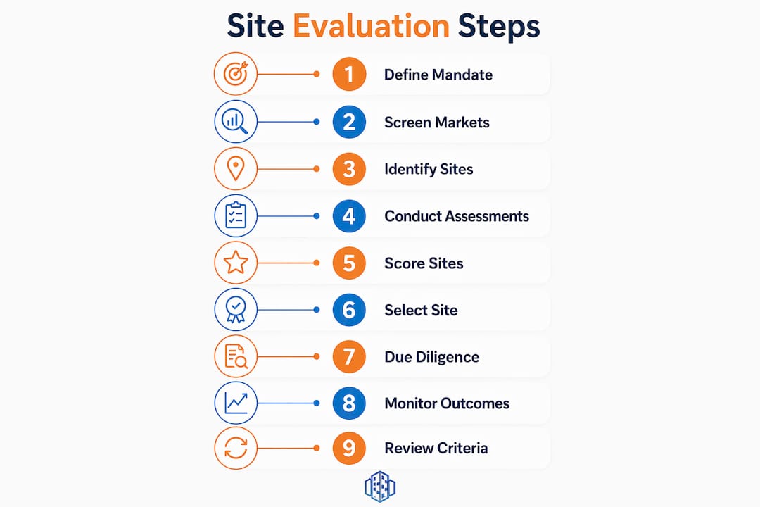
A stepwise site analysis maps from strategic intent through to go-live monitoring, covering nine distinct stages that urban planners should follow in sequence. Skipping stages or conflating them is the most common cause of poor site decisions.
- Define the growth mandate and site selection criteria. Establish what the project must achieve, what scale of development is required, and which site characteristics are non-negotiable. This stage produces a written brief that governs all subsequent steps.
- Screen markets and submarkets. Analyse geographic markets at a macro level to identify where demand, policy support, and infrastructure capacity align with the project brief. This narrows the field before individual sites are considered.
- Identify candidate sites and define trade areas. Within shortlisted markets, identify specific parcels or buildings that meet the initial size, location, and accessibility criteria. Define the trade area or catchment zone for each candidate.
- Conduct site reconnaissance. Visit each candidate site to observe physical conditions, access points, adjacent land uses, and visible environmental indicators. The Phase I ESA site reconnaissance is observational, not a sampling event; its value depends entirely on the rigour of the environmental professional’s judgement in synthesising observations with historical and regulatory data. Interviews with site occupants and neighbouring landowners add qualitative depth that desk-based research cannot replicate.
- Score and rank candidate sites. Apply a weighted scoring model to each candidate, using the criteria defined in Stage 1. Scoring should be transparent and auditable, with each criterion scored independently before weights are applied.
- Assess environmental and legal constraints. For shortlisted sites, commission Phase I Environmental Site Assessments and legal title reviews. The EPA’s Superfund process exemplifies a risk-filtering approach that moves from limited data collection to targeted investigation only when risks justify the additional effort and cost.
- Conduct feasibility analysis. A development feasibility study combines physical, legal, financial, and commercial analyses to determine definitively whether a site is buildable. This stage tests development layouts against combined constraints, including topography, access, zoning, and infrastructure capacity, rather than treating each factor in isolation.
- Final selection, committee approval, and documentation. Present the scored, ranked, and feasibility-tested shortlist to the decision-making committee. Structured evidence outputs form a transparent decision trail from initial screening through to approval.
- Post-selection monitoring and feedback. After a site is selected and development proceeds, track actual performance against the assumptions made during evaluation. This feedback loop improves the accuracy of future assessments.
Pro Tip: Record the rationale for every scoring decision in writing at the time it is made. Committees and planning inspectors frequently revisit site selection decisions months or years later, and contemporaneous documentation is far more credible than retrospective justification.
The table below maps each stage to its primary output:
| Stage | Primary output |
|---|---|
| Define mandate | Written project brief and criteria matrix |
| Screen markets | Shortlist of viable geographic markets |
| Identify candidates | Candidate site register with trade area maps |
| Site reconnaissance | Reconnaissance report with photographic record |
| Score and rank | Weighted scoring matrix with ranked shortlist |
| Environmental and legal assessment | Phase I ESA reports and title reviews |
| Feasibility analysis | Feasibility report with financial modelling |
| Committee approval | Decision record and approved site |
| Post-selection monitoring | Performance validation report |
How to conduct environmental and physical site assessments

Physical and environmental assessment is the stage where desk-based assumptions meet ground-level reality. The physical features you need to record and analyse include topography and slope, hydrology and drainage patterns, existing vegetation and its implications for subsurface conditions, site size and configuration, and any visible evidence of previous industrial or commercial use.
The Phase I Environmental Site Assessment, governed by ASTM E1527 in the United States and equivalent standards in the UK, has four mandatory components: records review, site reconnaissance, interviews, and a written report. Thorough site reconnaissance by a qualified environmental professional enhances the accuracy of the Phase I ESA and avoids the false security that superficial inspections create. The reconnaissance must cover building interiors, exteriors, adjacent properties, and any areas of stained soil, stressed vegetation, or unusual odours.
A Phase I ESA identifies Recognised Environmental Conditions (RECs) but does not confirm contamination through sampling. Where RECs are identified, a Phase II ESA involving soil and groundwater sampling is required to characterise the actual risk.
The site analysis checklist for urban development projects covers the following categories as part of due diligence:
- Title and ownership verification
- Zoning compliance and planning history
- Environmental conditions and Phase I ESA findings
- Geotechnical conditions and ground stability
- Utilities availability and capacity
- Engineering constraints including access and drainage
- Construction feasibility and programme implications
- Financial and tax considerations
Geotechnical investigations deserve particular attention. Targeting geotechnical investigations based on expected load-bearing requirements and geological variability is the correct approach. Both token boreholes and excessive sampling programmes produce misleading or inefficient data. The investigation scope should be calibrated to the development type and the geological risk profile of the site.
What tools and models support site scoring and decision-making?
Scoring and ranking candidate sites objectively requires a framework that assigns weighted criteria to each evaluation dimension. The criteria weights should reflect the project’s growth mandate: a logistics facility will weight access and infrastructure capacity heavily, whilst a residential scheme will prioritise planning policy alignment and community infrastructure.
The comparison below illustrates how two common scoring approaches differ in practice:
| Scoring approach | Strengths | Limitations |
|---|---|---|
| Weighted linear model | Transparent, auditable, easy to explain to committees | Assumes criteria are independent; sensitive to weight selection |
| Multi-criteria decision analysis (MCDA) | Handles interdependencies between criteria | More complex to build and communicate |
| Binary threshold screening | Fast for initial shortlisting | Loses nuance; may eliminate viable sites prematurely |
Spatial analysis platforms such as QGIS, Esri ArcGIS, and 3dcityplanner support the integration of scoring criteria with geographic data layers, allowing planners to visualise how candidate sites perform across multiple dimensions simultaneously. The urban development workflow supported by 3D modelling tools allows teams to test development scenarios against site constraints in real time, which strengthens the feasibility analysis stage considerably.
Financial modelling must be integrated into the scoring process, not treated as a separate exercise conducted after site selection. Integrating physical, legal, and financial data into a single evaluation framework produces defensible decisions, particularly for public-sector projects where transparency and accountability are paramount.
Pro Tip: Tailor the scope of your geotechnical and environmental investigations to the risk profile of each site rather than applying a standard programme to every candidate. A site with no historic industrial use and stable geology requires a lighter investigation than a former industrial parcel in a flood zone. Calibrating investigation scope reduces cost without increasing risk.
The site evaluation criteria used in the scoring model should be reviewed and updated after each completed project to incorporate lessons learned. A scoring model that is never revised gradually loses its predictive accuracy as market conditions and planning policy evolve.
What I have learned from years of site evaluation practice
After working through dozens of site evaluation processes across urban regeneration, residential, and mixed-use projects, the pattern that separates successful evaluations from costly failures is almost always the same. Teams that define their non-negotiable criteria in writing before they look at a single site make better decisions. Teams that treat site reconnaissance as a box-ticking exercise rather than a genuine investigative process consistently underestimate environmental and physical risk.
The most underrated step in the entire process is post-selection monitoring. Most organisations invest heavily in the evaluation phase and then move on without ever validating whether their scoring assumptions were accurate. That feedback loop is where institutional knowledge is built. Without it, you repeat the same estimation errors on every subsequent project.
I have also seen how maintaining a structured site database transforms the efficiency of repeated evaluations. A detailed site database prevents redundant fieldwork and accelerates consistent evaluations across urban reuse projects. Building that database takes discipline in the early projects, but the return on that investment compounds over time.
The integration of 3D visualisation and spatial modelling tools into the evaluation process has genuinely changed what is possible at the feasibility stage. Being able to test a development massing against a site’s topography, sightlines, and shadow impact in real time removes a significant source of uncertainty from the committee approval stage. That is not a minor efficiency gain. It is the difference between a committee approving a scheme with confidence and deferring a decision because the evidence is not clear enough.
— Anne
How 3dcityplanner supports your site evaluation process
3dcityplanner is a digital platform built specifically for urban development professionals who need to evaluate, model, and communicate site decisions with precision. The platform integrates spatial data layers, 3D building generation, sightline visualisation, and noise impact simulation into a single working environment, which means your evaluation team works from one consistent dataset rather than reconciling outputs from multiple disconnected tools. For teams conducting multi-criteria site assessments, 3dcityplanner’s 4D planning capability allows development scenarios to be tested and adjusted in real time, supporting both the feasibility analysis and committee approval stages of the site evaluation process. The platform is accessible to teams at all experience levels and offers a trial period without prior payment commitment.
FAQ
What is site evaluation in urban development?
Site evaluation in urban development is a structured process for assessing candidate sites across physical, environmental, legal, and financial dimensions to determine their suitability for a proposed project. The process follows sequential stages from initial screening through to feasibility validation and committee approval.
How many steps does a thorough site evaluation involve?
A thorough site evaluation typically involves nine stages, covering mandate definition, market screening, candidate identification, site reconnaissance, scoring, environmental and legal assessment, feasibility analysis, committee approval, and post-selection monitoring.
What is a Phase I ESA and when is it required?
A Phase I Environmental Site Assessment is an observational review of a site’s environmental conditions, governed by ASTM E1527, that identifies Recognised Environmental Conditions without physical sampling. It is required during the environmental assessment stage of site evaluation whenever there is a reasonable possibility of historic contamination.
What criteria are used in a site scoring model?
Site scoring models typically weight criteria including market demand, planning policy alignment, infrastructure capacity, environmental risk, accessibility, physical constraints, and financial viability. The specific weights assigned to each criterion should reflect the project’s growth mandate and land use type.
How long does a site evaluation due diligence process take?
Typical due diligence processes for development sites involve engaging specialist consultants and take between 60 and 120 days to complete, depending on the complexity of environmental, legal, and geotechnical investigations required.