How to create an urban masterplan with 3D technology

Urban development demands more than static blueprints and disconnected datasets. As cities face rapid population growth, climate pressures, and evolving mobility needs, traditional planning struggles with complex data integration and real-time visualisation. Advanced 3D technology transforms this landscape, enabling planners to model scenarios, engage stakeholders interactively, and deliver masterplans that adapt to future challenges. This guide provides a clear, actionable pathway to leverage 3D tools for superior urban masterplanning outcomes.
Table of Contents
- Understanding the urban masterplanning process
- Key requirements and digital tools for urban masterplanning
- Step-by-step guide to creating an urban masterplan using 3D technology
- Troubleshooting and common pitfalls in digital masterplanning
- Measuring success and best practices for continuous improvement
- Advanced 3D tools for next-generation urban masterplanning
- Frequently asked questions
Key Takeaways
| Point | Details |
|---|---|
| Masterplan definition | An urban masterplan is a comprehensive blueprint that coordinates all major facets of city growth and design. |
| Essential tools | Digital twins and 3D software form the backbone of effective and future-proof urban planning. |
| Step-by-step framework | Following a clear, sequenced process is key for building robust and adaptable urban masterplans. |
| Pitfall awareness | Anticipating common mistakes helps teams troubleshoot and ensure project success. |
| Continuous improvement | Measuring KPIs and embracing iterative updates enable long-term masterplan performance. |
Understanding the urban masterplanning process
An urban masterplan is a strategic framework that guides the physical, social, and economic development of a city or district over a defined period. It addresses land use allocation, transport networks, infrastructure provision, environmental sustainability, and public space design. Effective masterplans balance competing interests whilst ensuring long-term resilience and livability.
Traditional 2D planning processes rely on static maps, spreadsheets, and lengthy approval cycles. These methods struggle to integrate diverse datasets, visualise complex spatial relationships, or facilitate meaningful stakeholder dialogue. As urban challenges intensify, planners need collaborative, data-driven approaches that support rapid iteration and transparent decision-making.
Key objectives of contemporary urban masterplanning include:
- Land use optimisation: Allocating space for residential, commercial, industrial, and recreational functions
- Mobility and connectivity: Designing transport networks that reduce congestion and support sustainable modes
- Infrastructure resilience: Planning utilities, drainage, and energy systems that withstand future demands
- Environmental sustainability: Integrating green spaces, biodiversity corridors, and climate adaptation measures
- Public realm quality: Creating inclusive, accessible spaces that enhance community wellbeing
The shift towards sustainable urban masterplanning reflects growing recognition that cities must deliver social equity, economic vitality, and environmental stewardship simultaneously. Digital tools enable planners to model these interdependencies and test scenarios before committing resources.
“The masterplan is not a fixed endpoint but a living framework that evolves with community needs and technological capabilities.”
Key requirements and digital tools for urban masterplanning
Launching a robust masterplan project requires assembling the right data, regulatory context, and technological infrastructure. Core requirements include spatial datasets (cadastral boundaries, topography, existing infrastructure), policy frameworks (zoning regulations, design codes, sustainability targets), stakeholder input (community priorities, developer interests, agency mandates), and performance metrics (density thresholds, transport capacity, environmental indicators).
Digital twin technology and 3D planning platforms elevate this foundation by enabling real-time scenario visualisation and collaborative analysis. Digital twins create living simulation environments that mirror physical conditions and test interventions before implementation. These platforms integrate GIS data, building information models, and sensor feeds to provide a single source of truth for all project participants.

Minimum data and materials for masterplan initiation:
| Data category | Essential elements | Format |
|---|---|---|
| Spatial | Cadastral parcels, topography, existing buildings | GIS shapefiles, 3D models |
| Regulatory | Zoning maps, design guidelines, heritage constraints | PDF, GIS layers |
| Infrastructure | Transport networks, utilities, drainage systems | CAD drawings, GIS data |
| Environmental | Green spaces, flood zones, air quality | Raster datasets, sensor data |
| Demographic | Population density, employment centres, service demand | Census tables, surveys |
Advanced 3D planning tools support generative design, where algorithms propose layout options based on defined parameters. This accelerates exploration of alternatives and reveals solutions that manual methods might miss. Cloud-based platforms ensure all team members access current information, reducing version control issues and coordination delays.
Pro Tip: Invest in interoperable cloud platforms that support open data standards. This future-proofs your workflow and enables seamless collaboration with external consultants and agencies.
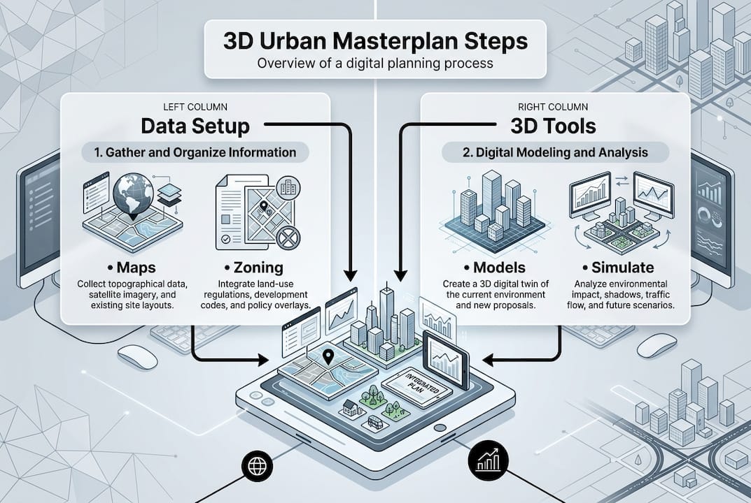
Step-by-step guide to creating an urban masterplan using 3D technology
Creating an effective urban masterplan using 3D technology follows a structured sequence that maximises collaboration, data accuracy, and stakeholder engagement. Each stage builds on the previous, ensuring decisions are evidence-based and transparent.
- Project initiation and scoping: Define objectives, boundaries, and success criteria. Establish governance structures, identify key stakeholders, and secure necessary data access agreements. 3D platforms enable early visualisation of the study area, helping teams align on scope and priorities.
- Data collection and integration: Gather spatial, regulatory, and demographic datasets. Import these into your digital urban planning platform, ensuring coordinate systems align and data quality is validated. Automated building generation tools can populate the 3D environment rapidly, providing context for subsequent design work.
- Baseline modelling: Create a digital representation of existing conditions, including buildings, infrastructure, land use, and environmental features. This baseline serves as the reference point for all scenario testing and impact assessment.
- Scenario development: Generate multiple design alternatives that respond to different priorities (e.g., maximum density, green space preservation, transport efficiency). Use generative design tools to explore a wider solution space than manual methods allow. 3D visualisation makes trade-offs explicit and supports informed decision-making.
- Impact analysis and testing: Evaluate each scenario against performance metrics such as transport capacity, environmental quality, economic viability, and social equity. Digital twins enable dynamic simulation of traffic flows, energy consumption, and climate impacts, revealing consequences that static plans cannot capture.
- Stakeholder engagement and refinement: Present scenarios through interactive dashboards and immersive visualisations. Gather feedback from community groups, developers, and regulatory agencies. 3D platforms facilitate transparent dialogue by making design implications tangible and accessible to non-technical audiences.
- Plan finalisation and approval: Refine the preferred scenario based on stakeholder input and technical analysis. Prepare documentation for regulatory approval, including 3D visualisations, performance reports, and implementation phasing. The urban planning workflow ensures all compliance requirements are met efficiently.
- Implementation monitoring: Use the digital twin as a management tool during construction and operation. Track progress against milestones, identify deviations early, and adjust plans as conditions change. This continuous feedback loop maintains alignment between vision and reality.
Comparison: 2D vs. 3D masterplanning approaches
| Aspect | 2D masterplanning | 3D masterplanning |
|---|---|---|
| Visualisation | Static maps, sections | Interactive 3D models, real-time rendering |
| Data integration | Manual, fragmented | Automated, centralised |
| Scenario testing | Limited, time-intensive | Rapid, algorithm-assisted |
| Stakeholder engagement | Technical drawings, difficult to interpret | Immersive, accessible visualisations |
| Collaboration | Sequential, version control issues | Concurrent, cloud-based |
| Impact analysis | Qualitative estimates | Quantitative simulations |
Pro Tip: Use interactive dashboards for stakeholder presentations. Allow participants to toggle layers, adjust parameters, and explore scenarios themselves. This builds ownership and surfaces concerns early.
Troubleshooting and common pitfalls in digital masterplanning
Even with advanced tools, digital masterplanning projects encounter predictable challenges. Recognising these early and applying targeted mitigation strategies keeps projects on track and maintains stakeholder confidence.
Typical errors and challenges:
- Uncoordinated data sources: Datasets from different agencies often use inconsistent formats, coordinate systems, or update frequencies. This creates integration headaches and undermines analysis accuracy.
- Overcomplicated interfaces: Platforms with steep learning curves discourage adoption and limit participation. Teams revert to familiar 2D methods, negating digital investment.
- Stakeholder misalignment: Without clear communication protocols, different groups develop conflicting expectations about project scope, timelines, and outcomes.
- Incomplete datasets: Missing or outdated information forces planners to make assumptions, reducing confidence in scenario results.
- Insufficient training: Teams lack the skills to exploit platform capabilities fully, leading to underutilisation and frustration.
Mitigation strategies include establishing data governance protocols at project outset, selecting platforms with intuitive interfaces and strong support resources, conducting regular cross-team reviews to maintain alignment, validating all data sources and documenting assumptions transparently, and investing in comprehensive training programmes for all project participants.
Integration issues and incomplete datasets are top challenges in 3D planning deployment. Addressing these proactively through robust data management and stakeholder engagement frameworks significantly improves project outcomes.
“The most successful digital masterplanning projects prioritise people and processes over technology. Tools enable collaboration, but clear communication and shared purpose drive results.”
Regular audits of data quality, platform performance, and team satisfaction help identify issues before they escalate. Establishing feedback loops where users can report problems and suggest improvements fosters continuous refinement of workflows and tools.
Measuring success and best practices for continuous improvement
Evaluating masterplan effectiveness requires defining clear key performance indicators (KPIs) and establishing monitoring systems that track outcomes over time. Success metrics should align with project objectives and reflect the priorities of all stakeholder groups.
Core KPIs for urban masterplan success:
- Stakeholder engagement: Participation rates, feedback quality, satisfaction scores
- Design accuracy: Alignment between planned and delivered outcomes, error rates in documentation
- Regulatory compliance: Approval timelines, number of revisions required, adherence to codes
- Sustainability impact: Carbon reduction, green space provision, biodiversity enhancement
- Economic viability: Development feasibility, infrastructure cost efficiency, return on investment
- Social equity: Accessibility improvements, affordable housing delivery, community benefit realisation
Post-implementation reviews compare actual performance against these KPIs, identifying lessons for future projects. Ongoing measurement and optimisation are hallmarks of successful 3D urban masterplans. Digital twins facilitate this by providing real-time data on how built environments perform, enabling adaptive management and continuous improvement.
Best practices for iterative masterplanning include scheduling regular review cycles (quarterly or annually) to assess progress and adjust strategies, maintaining the digital twin as a living asset that evolves with the physical environment, documenting lessons learned and sharing knowledge across projects and teams, engaging communities in ongoing dialogue about how plans are meeting their needs, and leveraging analytics to identify patterns and inform future design decisions.
Establishing a culture of continuous improvement ensures masterplans remain relevant as conditions change. The 3D planning workflow supports this by making updates efficient and transparent, reducing the friction that often prevents plans from adapting to new information.
Advanced 3D tools for next-generation urban masterplanning
Equipped with knowledge and best practices, you might now be considering the ideal tools to accelerate your urban masterplanning journey. Advanced 3D planning platforms transform how teams collaborate, analyse scenarios, and engage stakeholders throughout the masterplan lifecycle.
The 3D Cityplanner platform provides a comprehensive environment for designing, testing, and managing urban masterplans. Automated building generation, line-of-sight analysis, noise simulation, and 4D timeline visualisation enable planners to explore design implications rapidly and communicate findings clearly. The platform’s cloud-based architecture supports real-time collaboration across distributed teams, whilst extensive global building and infrastructure databases accelerate baseline modelling.
Whether you’re developing a district masterplan, evaluating transport corridors, or assessing environmental impacts, the city planning tool by StrateGis delivers the functionality and flexibility modern projects demand. Intuitive interfaces reduce training time, whilst powerful analytics provide the evidence base for confident decision-making. Trial periods allow teams to explore capabilities without upfront commitment, ensuring the platform aligns with project needs before full deployment.
Frequently asked questions
What is the main advantage of 3D urban masterplanning?
3D urban platforms enable real-time collaboration, scenario visualisation, and more accurate data integration than traditional methods, improving decision quality and stakeholder engagement.
Which digital tools are most effective for urban masterplanning?
Digital twins and 3D models provide superior planning adaptability, enabling dynamic simulation and comprehensive scenario testing for resilient masterplans.
How can stakeholder engagement be improved with 3D tools?
3D tools facilitate broader input and clearer visual communication through interactive presentations and transparent scenario testing accessible to all participants.
What are the common pitfalls of digital masterplanning?
Common pitfalls include poor data integration, insufficient training, and lack of stakeholder alignment. Integration issues are a leading obstacle to smooth digital masterplanning deployment.


