How real-time collaboration transforms urban planning

Many urban planning teams adopt the latest digital platforms and expect seamless coordination to follow automatically. The reality is more complicated. Even the most sophisticated collaborative tools can fail to deliver when organisational silos, fragmented data, and limited digital capacity remain unaddressed. This article examines the genuine mechanics behind real-time collaboration in urban planning, presenting evidence from recent projects, exposing key governance barriers, and offering practical guidance on choosing the right tools and workflow combinations to achieve measurable gains in project efficiency and stakeholder engagement.
Key Takeaways
| Point | Details |
|---|---|
| Integration is essential | Effective real-time collaboration relies on the integration of GIS, BIM, and centralised engineering data, not just live editing features. |
| Governance matters most | Without addressing organisational silos and weak data-sharing, even advanced tools cannot unlock their full value in urban planning. |
| Modes must match context | Choose collaboration tools and workflows that are fit for both synchronous team work and asynchronous public participation for best results. |
| Digital twins have limits | Digital twins and simulations are invaluable for scenario planning but cannot predict or optimise outcomes in truly complex urban systems. |
What does real-time collaboration mean for urban planning?
Real-time collaboration in urban planning refers to the live, simultaneous coordination of multiple project teams, stakeholders, and decision-makers through shared digital environments. Rather than exchanging static files or waiting for scheduled review meetings, teams can view, edit, comment on, and respond to project data as it changes. This fundamentally alters how planning decisions are made and how quickly they can be acted upon.
In practice, real-time collaboration for urban professionals involves several interconnected capabilities:
- Multi-user live editing: Multiple team members work within the same geospatial environment simultaneously, seeing each other’s changes as they happen.
- BIM and GIS integration: Building Information Modelling (BIM) data and Geographic Information System (GIS) layers are combined so that engineering and spatial planning teams share a single source of truth rather than working from disconnected files.
- Centralised issue tracking: Project issues, design conflicts, and review comments are georeferenced and visible to all authorised users, reducing the risk of miscommunication between disciplines.
- Stakeholder portals: External stakeholders, including local councils, community groups, and developers, can access curated views of project data without needing specialist software licences.
The urban planning collaboration features available on modern platforms reflect how rapidly this field has matured. For multi-actor infrastructure planning, structured BIM and GIS integrations allow teams to make coordinated decisions in geographic context rather than through disconnected files, which is a decisive advantage when multiple agencies or contractors are involved.
The core benefits of real-time collaboration translate directly into planning and development outcomes. Faster decision cycles emerge because approvals and change requests no longer sit idle in email chains. Better project coordination results from everyone working against the same current dataset. And richer stakeholder engagement becomes possible when community members or government bodies can interact with live 3D models rather than printed drawings. When you review software with collaboration tools designed specifically for urban planning contexts, you will notice that the most effective solutions combine all three of these outcomes within a single integrated environment.

Key benefits realised: evidence from recent urban projects
Understanding the mechanics is one thing. Demonstrating that these tools produce measurable improvements is another. Fortunately, rigorous research is beginning to fill the evidence gap.
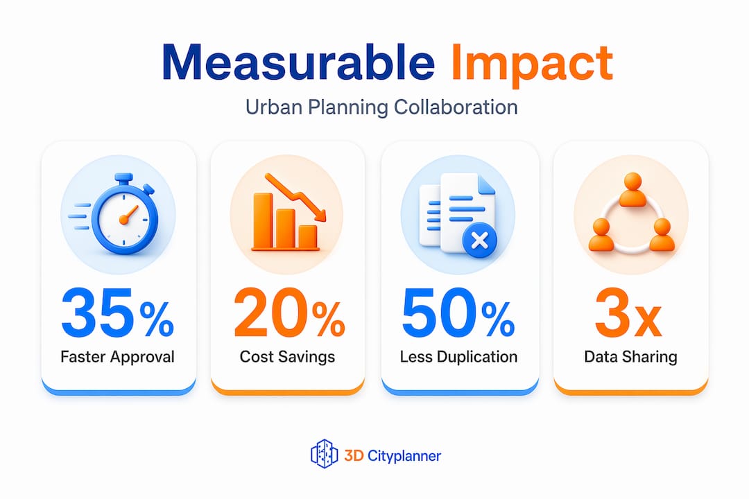
Empirical urban-governance research from Yerevan between 2019 and 2023 provides some of the clearest data yet available on what happens when digital collaboration instruments are embedded within formal planning governance structures. The findings are encouraging, but they also carry important caveats that practitioners would be wise to take seriously.
| Metric | Outcome (Yerevan, 2019–2023) |
|---|---|
| Project cycle reduction | Significant decrease in average approval timelines |
| GIS platform uptake | Increased cross-agency adoption |
| Annual cost savings | Approximately $1.2 million via reduced duplication |
| Administrative efficiency | Measurable improvement in inter-agency data sharing |
| Key barrier identified | Data fragmentation and organisational silos |
These figures illustrate that the financial case for collaborative digital tools is real. Reduced duplication of effort alone accounts for substantial savings, while faster approval cycles free up resources that can be redeployed to project delivery. The BIM integration benefits in this context are particularly significant: when engineering data is centralised and georeferenced, teams spend less time reconciling conflicting datasets and more time making informed decisions.
For teams working with spatial data across multiple agencies, the value of tools with GIS integration extends beyond convenience. When planners, traffic engineers, environmental consultants, and infrastructure teams all draw from the same live data layer, the risk of costly downstream errors decreases considerably.
Pro Tip: The Yerevan research makes clear that cost and efficiency gains are not automatic. They depend on breaking down organisational silos before or alongside tool adoption. If your agency’s data governance is fragmented, prioritise a data-sharing protocol first, then layer collaboration software on top of a functioning structure.
Unique challenges: governance, data silos and the complexity conundrum
With the evidence of benefits established, it is important to present the fuller picture. Digital collaboration tools are genuinely powerful, but they are not solutions in themselves. Several structural challenges can limit or even neutralise their impact.
The most common barriers in urban planning contexts are:
- Fractured data environments: Different agencies store spatial data in incompatible formats, with inconsistent naming conventions and update schedules that prevent meaningful real-time exchange.
- Siloed organisational cultures: Even when technical integration is possible, teams accustomed to working independently may resist sharing draft data or interim decisions, viewing transparency as a governance risk rather than an advantage.
- Digital skills gaps: Real-time collaboration platforms require users at all levels, including senior decision-makers and public stakeholders, to engage with interfaces that may feel unfamiliar or demanding.
- Procurement and licensing constraints: Public-sector agencies often face lengthy procurement cycles that prevent rapid adoption of new collaborative tools, even when the business case is clear.
Beyond these organisational challenges, there is a deeper structural issue that deserves attention. Research into digital twin urban planning and complex urban systems has surfaced an important limitation: urban environments are emergent and unpredictable, meaning that even the most sophisticated simulation environments cannot reliably predict every planning outcome.
“For complex urban problems, digital twins and collaborative simulations should be framed as decision-support tools for exploring plausible futures and surfacing inconsistencies, rather than expecting linear, efficiency-driven optimisation outcomes.” Springer digital twins research
This is not an argument against using advanced tools. It is an argument for using them with appropriate expectations. Urban digital twins are extraordinarily valuable for scenario testing, visualising trade-offs, and facilitating stakeholder dialogue. They become problematic only when teams treat their outputs as definitive predictions rather than as inputs to informed human judgement.
The governance dimension matters enormously here. When data is fragmented across agencies and organisational silos remain intact, even real-time editing capabilities cannot compensate for the absence of shared decision-making authority. Technology enables coordination; governance structures make it sustainable.
Modes of collaboration: synchrony, participation, and tool choice
Not all real-time collaboration looks the same in practice. Understanding the distinction between synchronous and asynchronous interaction is essential for choosing the right tools and designing the right workflows for your project context.
Synchronous collaboration occurs when participants interact with a shared environment at the same time. In urban planning, this might involve a multidisciplinary design workshop where architects, planners, and engineers simultaneously adjust a 3D city model, with each change immediately visible to all participants. This mode is highly productive for resolving conflicts quickly and building shared understanding.
Asynchronous collaboration occurs when participants contribute at different times. A community stakeholder might review a proposed development model in the evening and leave comments that the planning team addresses the following morning. This mode is essential for inclusive public engagement, where not all participants can attend synchronous sessions.
Research on real-time AR collaboration in public participation contexts reveals that shared editing can function very differently depending on whether participants are co-located with shared controls or using separate devices, which tends to shift the interaction toward asynchronous patterns. This has practical implications for how you design engagement sessions and which tools you select.
| Collaboration mode | Best suited to | Tool requirements | Risk factors |
|---|---|---|---|
| Synchronous | Internal design teams, expert workshops | Low-latency shared editing, live annotation | Requires coordinated schedules, can exclude some stakeholders |
| Asynchronous | Public consultation, cross-agency review | Comment threads, version control, notification systems | Slower resolution, risk of context loss |
| Hybrid | Large-scale urban projects | Combined live editing and persistent comment layers | Requires careful workflow governance |
Here is a practical framework for selecting your collaboration approach:
- Map your stakeholder groups by digital literacy, availability, and decision-making authority. Different groups may need different collaboration modes within the same project.
- Audit your data environment before selecting tools. If your spatial data lives in incompatible systems, resolve integration issues before introducing live collaborative editing.
- Choose tools that support both synchronous and asynchronous workflows within a single platform, so that internal teams and external stakeholders can contribute without being forced into the same session format.
- Establish governance rules for data editing: who can change what, when changes are committed, and how conflicts are resolved.
- Test with a pilot group before full deployment, particularly when public participation is involved, to identify usability barriers early.
Pro Tip: When selecting collaboration software options for projects involving both technical teams and public stakeholders, prioritise platforms that offer role-based access controls. This allows you to give community members a meaningful, curated view of the project without exposing sensitive design iterations or internal review comments. Review how digital twins in planning support layered access for exactly this reason.
A hard-won lesson: why the best tech is nothing without governance and hybrid practices
Here is a perspective worth stating plainly: the urban planning sector has a tendency to treat each new generation of digital tools as the answer to collaboration challenges that are fundamentally organisational in nature. The enthusiasm is understandable. Modern 3D platforms, live GIS environments, and digital twin simulations are genuinely impressive. But the evidence consistently points to the same conclusion.
Data fragmentation and organisational silos can limit coordination gains even when tools support real-time editing. Success depends on governance capacity and cross-agency data sharing, not only interface speed. This is the uncomfortable truth that technology vendors rarely emphasise: a poorly governed project running on a sophisticated platform will underperform a well-governed project running on simpler tools.
What actually works, based on both research evidence and practical experience, is the combination of strong digital infrastructure with sustained investment in the human and institutional layer. This means training that goes beyond tool onboarding to cover data stewardship responsibilities. It means cross-agency agreements that define who owns which datasets and how conflicts are resolved. And it means accepting that analogue practices, including face-to-face workshops, printed maps for community consultations, and verbal negotiation between agencies, still play a vital role alongside digital platforms.
Hybrid approaches, where digital environments support but do not replace human deliberation, tend to produce the most sustainable collaboration outcomes. A digital twins and planning transformation approach works best when it is paired with clear governance structures that give every participant confidence in the integrity of the shared data environment.
Our advice to urban planning professionals is this: budget as deliberately for process design and capacity building as you do for software licences. The technology will only perform as well as the organisational culture around it permits.
Transform your urban planning projects with 3D Cityplanner
Real-time collaboration is not a feature you simply switch on. It is a practice built on the right tools, the right governance, and the right workflow design. If this article has clarified what that combination looks like in practice, the natural next step is exploring a platform built specifically to support it.
The 3D Cityplanner platform brings together live GIS and BIM integration, multi-user 3D editing, stakeholder engagement portals, and 4D timeline planning within a single, accessible environment. Whether you are coordinating a multidisciplinary infrastructure project or managing community consultation for a new development, the platform provides the structured, georeferenced collaboration environment that translates directly into faster decisions, reduced duplication, and richer stakeholder dialogue. Explore a free trial and see how integrated collaborative planning performs in your own project context.
Frequently asked questions
What is real-time collaboration in urban planning?
It is the live coordination between multiple project teams or stakeholders via digital platforms, with shared editing, georeferenced data, and centralised project issues. Structured BIM and GIS integrations allow teams to make coordinated decisions in geographic context rather than through disconnected files.
How do digital collaboration tools reduce urban project costs?
They reduce duplication of work, speed up approvals, and improve data sharing across agencies. Empirical research from Yerevan recorded annual cost savings of approximately $1.2 million through reduced duplication and faster approval processes between 2019 and 2023.
Do all urban planning collaboration tools enable true real-time participation?
Not necessarily. Actual real-timeness depends on workflow design, device usage, and the nature of stakeholder participation. Research on shared editing shows that co-located participants with shared controls behave synchronously, while separate device users tend toward asynchronous patterns.
Why might digital twins not deliver perfect decisions for complex urban systems?
Urban systems are inherently emergent and unpredictable. Digital twins and collaborative simulations are best framed as decision-support tools for exploring plausible futures rather than as instruments for linear, efficiency-driven optimisation.


