City master planning guide: Modern strategies and 3D tools

Master plans designed for a city in 2010 rarely survive contact with the city of 2026. Demographics shift, climate pressures intensify, and economic priorities pivot faster than traditional planning cycles can accommodate. Static documents filed in a drawer offer little defence against rapid urban change. What modern city master planning demands is a living, evidence-based process supported by 3D visualisation, digital twins, and continuous stakeholder engagement. This guide walks you through the foundations, the step-by-step workflow, the technology that is genuinely transforming practice, and the critical checks that separate plans which get built from those which gather dust.
Table of Contents
- Foundations of city master planning
- Step-by-step: How to create a robust master plan
- Digital twins and 3D tech: The game-changer in master planning
- Common pitfalls and critical checks
- Why practical, data-driven, and tech-enabled planning beats theory
- Next steps: Plan smarter with advanced 3D tools
- Frequently asked questions
Key Takeaways
| Point | Details |
|---|---|
| Plan review cycle | Review master plans every five years to stay effective and responsive. |
| 3D/digital twin integration | Modern planning tools like digital twins provide better analysis and stakeholder engagement than traditional methods. |
| Stakeholder focus | Involve stakeholders early and often to improve plan feasibility and buy-in. |
| Avoid common mistakes | Anticipate and verify growth, density, and resilience to prevent costly missteps. |
| Rules-based advantage | Adopting rules-based, evidence-driven processes can significantly boost housing delivery and plan adaptability. |
Foundations of city master planning
City master planning is not simply drawing boundaries on a map. It is a multi-scale, stakeholder-driven process that spans metropolitan strategy down to detailed site schemes, typically covering a 10 to 20 year horizon with formal reviews every five years. Done well, it coordinates land use, housing supply, mobility networks, green infrastructure, and economic growth targets into a single coherent framework.
Before a single line is drawn, you need the right foundations in place. These are the core components every robust master plan must address:
- Land use and zoning: Clear allocation of residential, commercial, industrial, and open-space zones aligned with growth projections.
- Housing targets: Quantified supply goals tied to demographic forecasts and affordability benchmarks.
- Mobility and connectivity: Integrated transport planning covering active travel, public transit, and freight.
- Green space and resilience: Minimum green quotas, flood risk corridors, and urban heat island mitigation.
- Economic growth scenarios: Employment land, mixed-use opportunities, and investment attraction strategies.
The table below summarises the essential tools and resources you should have ready before the planning process begins.
| Category | Example | Why needed |
|---|---|---|
| Spatial data | GIS layers, satellite imagery | Accurate base mapping and land analysis |
| Demographic data | Census, migration forecasts | Calibrate growth and housing targets |
| Stakeholder mapping | Community registers, agency lists | Ensure inclusive engagement from day one |
| Policy framework | Local development plans, national guidance | Maintain legal and strategic compliance |
| 3D/digital tools | Digital twin platforms | Scenario modelling and visual communication |
Following urban design principles from the outset ensures that your plan is not only technically sound but also human-centred and deliverable.
Pro Tip: Engage all stakeholders, including residents, developers, transport authorities, and utility providers, at the earliest possible stage. Early buy-in dramatically improves forecast accuracy and reduces costly objections later in the process.
Step-by-step: How to create a robust master plan
With your data assembled and stakeholders identified, the execution phase can begin. Evidence-based spatial analysis, scenario planning, and structured public engagement are the methodological pillars that distinguish plans which succeed from those which stall. Here is a practical workflow you can adapt to your context.
- Assemble your evidence base. Gather GIS data, population projections, economic forecasts, environmental constraints, and existing infrastructure capacity. Identify gaps and commission targeted surveys where needed.
- Conduct spatial analysis. Map existing land use, identify underutilised sites, assess transport accessibility, and model flood and climate risk zones.
- Develop growth scenarios. Build at least three scenarios: low, medium, and high growth. Each should carry distinct land use, housing, and infrastructure implications.
- Run stakeholder workshops. Present scenarios visually, using 3D models where possible, to make abstract projections tangible. Capture preferences, concerns, and local knowledge.
- Iterate and refine. Use workshop outputs to stress-test your preferred scenario. Adjust density assumptions, green space allocations, and transport links accordingly.
- Draft the master plan. Translate the refined scenario into a formal document with clear policies, phasing schedules, and monitoring indicators.
- Establish a review cycle. Set formal review triggers tied to sustainable city benchmarks and local delivery milestones.
‘A master plan grounded in real evidence will stand the test of politics and time.’
For a deeper look at how 3D planning strategies are reshaping this workflow, the evidence is compelling.
Pro Tip: Schedule scenario reviews at least annually during the first five years of implementation. This is your earliest opportunity to catch growth over or underestimation before it becomes a structural problem.
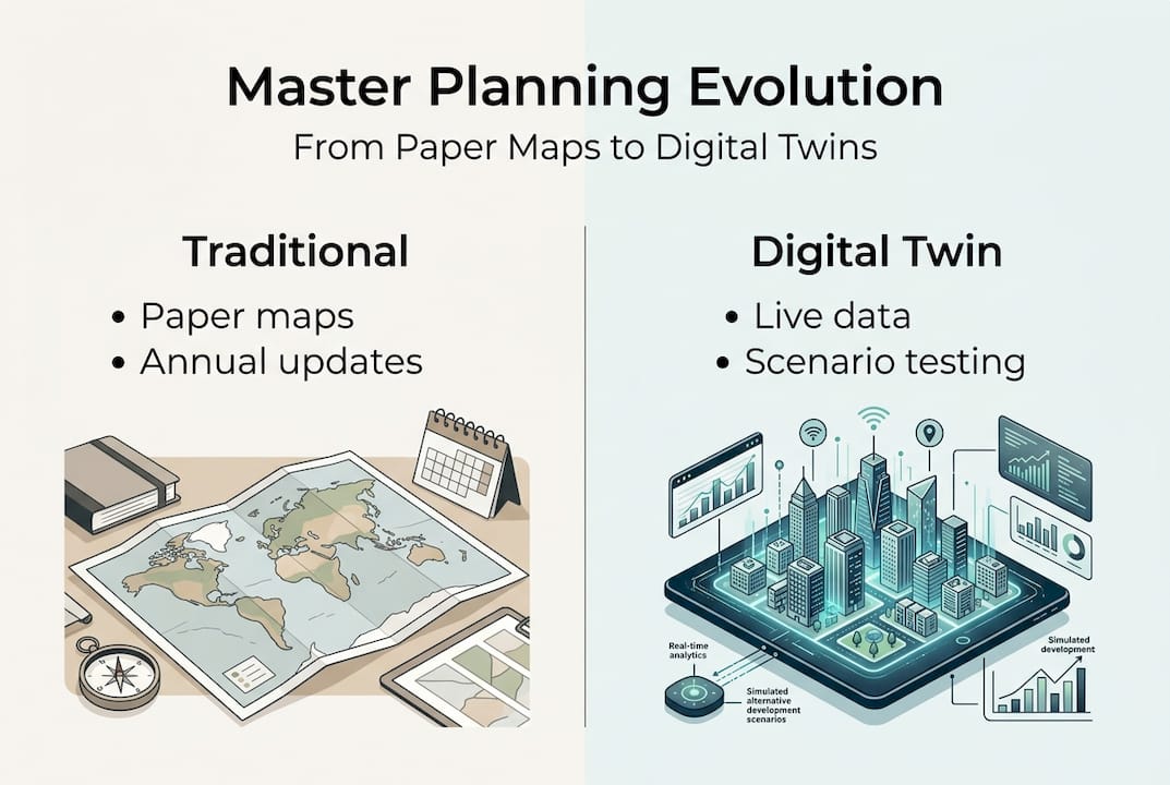
Digital twins and 3D tech: The game-changer in master planning
A digital twin is a dynamic, data-connected virtual model of a city or district that mirrors real-world conditions and allows planners to simulate change before it happens. Unlike a static 3D render, a digital twin updates as conditions evolve, making it a living simulation environment rather than a one-off visualisation.

The contrast with traditional methods is stark. The table below illustrates why forward-thinking planning authorities are making the switch.
| Dimension | Traditional methods | Digital twin approach |
|---|---|---|
| Accuracy | Dependent on periodic surveys | Continuously updated from live data feeds |
| Cost efficiency | High revision costs mid-cycle | Scenario changes made in minutes |
| Speed | Months for major plan updates | Real-time modelling and iteration |
| Stakeholder buy-in | Abstract maps, limited engagement | Immersive 3D visuals, intuitive communication |
Platforms such as ArcGIS and VU.CITY allow planners to import BIM models, run viewshed and flood impact assessments, and test massing options against policy constraints. The digital twins revolution in urban planning is producing measurable results. In Croydon, a rules-based digital approach demonstrated the potential to increase housing delivery by over 6,000 units per year across London through consistent, data-driven site assessment.
The four decisive advantages of digital twin technology for master planning are:
- Real-time simulation: Test policy changes, density increases, or transport interventions instantly.
- Better risk mitigation: Model flood, noise, and shadow impacts before committing to a layout.
- Improved collaboration: Share a single source of truth across planning teams, developers, and elected members.
- Visual buy-in: Communicate complex proposals to non-technical audiences with clarity and confidence.
The main pitfalls to watch for are data integration complexity and the need for staff upskilling. Investing in training early pays dividends. Research on density and ICT integration confirms that cities combining density management with digital tools achieve more balanced and resilient outcomes. Explore 3D modelling strategies to understand how these capabilities translate into day-to-day planning practice.
Common pitfalls and critical checks
Even well-resourced planning teams fall into predictable traps. Knowing what they are, and building in systematic checks, is what separates plans that deliver from those that disappoint. The empirical record is instructive: Varanasi’s built-up area expanded from 45 km² to 262 km², a growth of nearly 480%, far exceeding what most conventional plans had projected. That kind of underestimation cascades into infrastructure deficits, housing shortfalls, and transport gridlock.
The five most common errors in city master planning are:
- Growth estimation failures: Relying on single-point forecasts rather than scenario ranges leads to systematic under or overbuilding.
- Ignoring live feedback: Plans that do not incorporate monitoring and evaluation data quickly become disconnected from reality.
- Neglecting edge-case lessons: Dismissing outlier case studies, like rapid densification in secondary cities, means repeating avoidable mistakes.
- Density and functional mismatches: Zoning for density without matching transport capacity or social infrastructure creates dysfunctional neighbourhoods.
- One-off engagement: Treating public consultation as a single event rather than an ongoing dialogue erodes trust and misses critical local knowledge.
To reduce these risks, build a monitoring and evaluation framework into the plan from the start. Set clear indicators for housing delivery, transport performance, green space coverage, and economic activity. Review them annually. For 3D redevelopment planning, digital tools make mid-cycle adjustments far more manageable than traditional methods allow.
A practical mid-term adjustment checklist should cover: density policy triggers, green space quota compliance, transport modal share targets, and affordable housing delivery rates. A TOD case study from Hawaii illustrates how transit-oriented development frameworks, when paired with regular review, can correct course efficiently without requiring a full plan revision.
Why practical, data-driven, and tech-enabled planning beats theory
Most master plans that fail do so not because of poor vision but because of poor adaptability. They are built around static maps and fixed assumptions, then filed away until the next formal review cycle. By that point, the city has already moved on.
The evidence is clear: density balance and ICT integration consistently outperforms design-led or top-down approaches in delivering measurable outcomes. Cross-disciplinary teams that combine planners, data scientists, transport engineers, and community representatives produce plans that are both technically rigorous and politically durable.
‘It’s not the plan but the ability to adapt using the right data and tools that defines city success.’
What most professionals still overlook is the implementation gap. A beautifully designed master plan with no monitoring framework is just an expensive document. The cities getting this right are those investing in digital twin urban planning as a continuous operational capability, not a one-off project deliverable. Real-time scenario testing, live GIS dashboards, and structured stakeholder forums are not optional extras. They are the infrastructure of effective planning in 2026.
Next steps: Plan smarter with advanced 3D tools
Understanding the pitfalls and best practices is one thing. Having the right platform to act on them is another. Advanced 3D tools save significant time at every stage of the master planning cycle, from initial spatial analysis through to stakeholder engagement and mid-cycle review.
3D Cityplanner offers digital twin solutions purpose-built for urban planning professionals. From automatic building generation and line-of-sight visualisations to noise simulation and 4D phasing timelines, the platform supports every stage of the master planning process. Explore the full range of 3D Cityplanner features and discover how teams across architecture, real estate development, and city planning are using these capabilities to make faster, better-evidenced decisions. A free trial is available with no upfront commitment.
Frequently asked questions
How often should a city master plan be reviewed or updated?
A city master plan should be formally reviewed every five years, with full updates each cycle covering the standard 10 to 20 year planning horizon. Annual monitoring of key delivery indicators is also strongly recommended between formal reviews.
What is the role of digital twins in city master planning?
Digital twins allow planners to test scenarios in real time, integrate live data, and communicate proposals visually to stakeholders. Platforms used in transit-oriented development demonstrate how 3D feasibility assessment and impact modelling improve both decision quality and public engagement.
What are the most common mistakes in city master planning?
The most common mistakes are overestimating or underestimating growth, failing to review plans regularly, and not integrating scenario modelling with feedback from ongoing stakeholder engagement. These errors compound over time and are difficult to correct without a structured monitoring framework.
How does rules-based planning improve housing delivery?
Rules-based systems, combined with digital tools, streamline approvals and apply consistent standards across sites. In Croydon, this approach demonstrated potential for 6,000+ additional housing units per year across London by removing discretionary delays on small sites.
Recommended
- How to create an urban masterplan with 3D technology – 3D Urban Development
- 3D City Modeling Software: The Ultimate Guide for Urban Planners & Developers - 3D Gebiedsontwikkeling
- 6 Top Urban Design Strategies for Modern Planners – 3D Urban Development
- Urban Development Workflow for Efficient 3D Planning – 3D Urban Development


