6–10 Week Pilot to Prove a Digital Twin Business Case for Planners and Developers
A digital twin earns its budget when it is tied to one measurable target, such as cutting site feasibility time by a third or reducing unplanned maintenance downtime by a fifth, not when it is pitched as a general innovation project. The pragmatic route is a two-stage rollout: a scoped pilot that proves the KPI within weeks, followed by a scaled deployment once the data and governance are ready. What follows is the method and checklist to write that case.
TL;DR:Focusing on a digital twin for a specific, measurable decision task like site feasibility or asset management ensures easier funding and clearer ROI metrics.Cost estimates depend heavily on scope, with pilots typically costing tens of thousands and full deployments reaching millions, depending on data complexity and live sensor integration.Starting with a short, well-defined pilot on a single site or district, with fixed success criteria and KPIs, maximizes the chance of validating value before scaling up.Prioritizing use cases with quick feedback loops, such as feasibility studies or scenario comparisons, yields faster, more credible results than aiming for comprehensive operational twins.Using browser-based platforms enables rapid testing and KPI generation within weeks, reducing procurement delays and supporting early stakeholder buy-in.
3D CityplannerValidate Your Planning Business CaseUse 3D Cityplanner to analyse and compare development scenarios, supporting data-driven decisions in early-stage feasibility studies and masterplanning.Explore 3D Cityplanner
Table of Contents
- What is a business case for a digital twin?
- Which digital twin use cases actually produce measurable value?
- What does a digital twin cost, and how do you estimate the return?
- How do you build a digital twin business case step by step?
- What data, architecture and governance does the case need to cover?
- Why start with a pilot before scaling your digital twin?
- How do you get stakeholders to approve and adopt a digital twin?
- How planning tools support early validation in practice
- What I have learned building digital twin business cases
- How 3D Cityplanner helps you validate your business case
- Sources
- FAQ
What is a business case for a digital twin?
A digital twin is a live, data-connected model of a physical asset, site or city area that lets you test decisions before you commit capital to them. The business case question is not “should we have one?” but “which decisions will this model make cheaper, faster or less risky?” That framing separates a funded pilot from a science project.
Three levels of sophistication matter here, and each unlocks a different set of returns.
- Visualisation twins replicate geometry and context, mainly building massing, infrastructure, and terrain, so stakeholders can see a proposal rather than imagine it from a plan. They are cheap to build and mostly de-risk communication and approval delays.
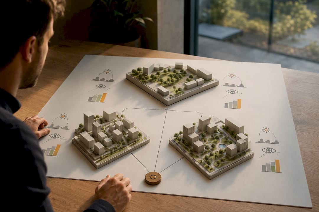
- Simulation twins add analytical layers such as sunlight studies, visibility analysis, parking capacity or traffic flow, letting planners test scenarios against real constraints before committing to a design. This is where most planning and development ROI lives.
- Live-operational twins connect to sensors and live data feeds, tracking asset performance, energy use or occupancy in near real time. These are the most expensive to run and typically only justified once an asset is built and operating.
Mapping value to decision jobs helps here. Design de-risking (avoiding a costly redesign after planning permission) sits mostly at the visualisation and simulation levels. Operations optimisation, such as reducing energy waste in a building portfolio, needs the live-operational layer. Strategic investment decisions, like comparing three redevelopment scenarios for a brownfield site, sit squarely in simulation territory and rarely need live data at all.
That last point is where many business cases go wrong: teams request budget for a full live-operational twin when the actual decision on the table, say, choosing between two masterplan options, only needs scenario simulation. Industry playbooks describe digital twins as tools for design testing and scenario analysis that de-risk capital decisions before money is committed, which is exactly the level most early-stage planning cases should target. Scope the sophistication level to the decision you are actually trying to make, not to the most impressive demo you have seen.
Which digital twin use cases actually produce measurable value?
The strongest business cases anchor to one use case with clear KPIs rather than trying to justify a platform for everything at once. Four use cases consistently produce numbers a finance committee can evaluate.
Site feasibility and acquisition screening. Before a developer commits to a land purchase or a municipality approves a rezoning request, a 3D scenario comparison shows development capacity, massing options and infrastructure conflicts in hours rather than weeks of manual GIS work.
- KPI: reduction in feasibility study turnaround time (weeks to days)
- KPI: number of scenarios evaluated per site before commitment
- KPI: stakeholder sign-off time on preferred option
Planning scenario comparison and masterplanning. Comparing housing density, greenery ratios, parking allocation and sunlight impact across multiple layout options lets planning teams present a defensible preferred scenario rather than a single untested proposal.
- KPI: number of objections raised at public consultation
- KPI: time from concept to planning submission
- KPI: variance between projected and approved development capacity
Asset operations and facilities management. Once a building or estate is live, a twin connected to sensor data can flag underperforming zones, from HVAC inefficiency to underused public space, before they become costly problems.
- KPI: reduction in unplanned maintenance downtime
- KPI: energy consumption per square metre against baseline
- KPI: reduction in reactive maintenance callouts
Infrastructure and supply-chain simulation. Testing how a new road layout, utility corridor or public transport route interacts with existing infrastructure avoids costly rework after construction starts.
- KPI: number of clashes or conflicts identified pre-construction
- KPI: reduction in change orders during construction
- KPI: cost avoidance from redesign prevented
Pro Tip: Pick the use case with the shortest time-to-KPI, not the one with the biggest theoretical upside. A four-week feasibility pilot that proves a 30% time saving is more fundable than a twelve-month operations twin with a projected but unproven return.
The evidence for infrastructure-scale returns is the most robust available. McKinsey’s analysis of public infrastructure investment finds that digital twins can improve capital and operational efficiency by roughly 20 to 30% on certain capital-intensive projects, largely by catching design conflicts and inefficiencies before construction locks them in. That range is a useful anchor for infrastructure business cases, though it should be treated as a sector benchmark rather than a guaranteed outcome for any single project. Smaller planning-scale pilots rarely generate published percentage figures, which is exactly why choosing a use case with a clean before/after metric, like feasibility turnaround time, matters more than borrowing an industry-wide statistic that does not fit your project’s scale.
What does a digital twin cost, and how do you estimate the return?
Costs vary enormously by scope, and the biggest mistake in early business cases is quoting a single number as if a digital twin were one product. It is more useful to think of cost as five separate components that each scale independently.
- Software licensing and platform access, typically a recurring subscription cost that scales with users, project count or data volume.
- Modelling effort, the work of building or importing 3D geometry, terrain and massing data, which can range from a few days for a small site to months for a full district model.
- Sensors and data piping, relevant only for live-operational twins, covering IoT hardware, telemetry feeds and the integration work to get that data flowing reliably.
- Integration with existing systems, connecting GIS, BIM, asset registers or municipal planning databases so the twin is not an isolated silo.
- Security and ongoing maintenance, covering access controls, data governance and the recurring effort to keep models current as projects evolve.
The NIST economics framework for digital twins offers a useful discipline here: it lays out a five-step investment-analysis method and provides published cost ranges showing that project-scale twins vary from the low tens of thousands for a scoped pilot to multiple millions for full building or infrastructure-scale deployments. That report also documents industry case studies showing building-scale digital twins costing anywhere from hundreds of thousands to multiple millions of dollars depending on data integration complexity and the number of systems connected. The variance is not noise. It reflects genuinely different scopes, and a business case that does not name its scope explicitly (pilot, single building, district, region) invites the finance committee to assume the largest number.
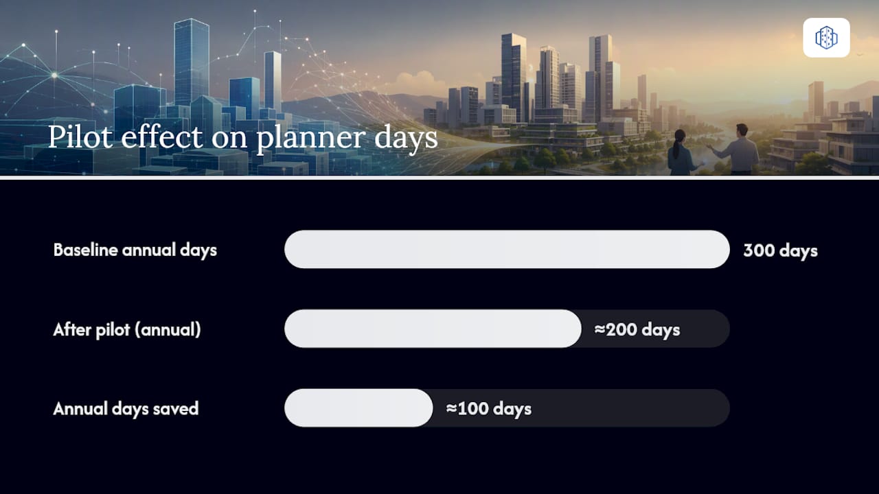
A simple worked example illustrates the logic, using assumptions you would need to state and defend in your own case, not figures to copy directly. Suppose a planning department spends the equivalent of 15 working days per feasibility study on manual GIS overlay and massing sketches, across 20 studies a year. A scenario-comparison pilot costing an equivalent of £25,000 to set up and run for six months, cutting that time by a third, would save roughly 100 working days annually. At an average planner day rate, that payback typically lands well inside twelve months, before counting the harder-to-quantify benefit of fewer planning appeals from clearer stakeholder communication.
Three assumptions in that kind of model need stress-testing before it goes into a board deck: the baseline time estimate (is 15 days realistic or optimistic?), the adoption rate (will planners actually use the new workflow, or default to old habits?), and whether the time saved converts into real cost avoidance or simply gets absorbed into other work. A business case that shows its assumptions survives scrutiny far better than one that hides them behind a single ROI percentage.
How do you build a digital twin business case step by step?
A funded business case follows a sequence, not a wish list. Skipping straight to a platform demo before defining the vision is the single most common reason these proposals stall in procurement.
- Define a measurable vision and pick one priority use case. Choose one or two KPIs, such as “reduce site feasibility turnaround from three weeks to five days” or “cut unplanned HVAC downtime by 20% within a year.” Resist the temptation to promise value across five use cases at once; a diluted vision is harder to fund and harder to prove.
- Map benefits to cost centres and stakeholders. Build a benefit realisation map that names who actually captures each saving. Faster feasibility studies save planning department time. Fewer redesigns save capital budget. Better stakeholder communication reduces legal and consultation costs. Each benefit needs an owner who will vouch for the number in front of finance.
- Inventory your data and assess readiness. List the data sources you already have (GIS layers, cadastral data, BIM models, asset registers), where the gaps are, and who owns each dataset. This step routinely surfaces the real blocker: not the modelling software, but the fact that three departments hold incompatible versions of the same base map. Industry guidance consistently flags data integration and governance as the primary investment that shortens time to value, ahead of the visualisation layer itself.
- Define pilot scope, success criteria, timeline and costs. This is where the Digital Twin Lite or MVP concept earns its place. Scope the pilot to a single site or a small district, two or three priority scenarios, and the KPIs chosen in step one. State the timeline (commonly six to ten weeks for a planning-scale pilot), the cost, and the specific threshold that counts as success, for example a 25% reduction in scenario preparation time compared with the current manual process.
- Plan for scale and governance before you need it. Even at pilot stage, name who will operate the twin once it moves beyond a proof of concept, what service levels apply, and which data standards and security controls will govern wider rollout. A pilot that succeeds but has no answer to “who runs this next” tends to stall exactly when it should be scaling.
Pro Tip: Write the pilot’s exit criteria before you start building anything. Deciding in advance what “good enough to scale” looks like stops a technically impressive pilot from drifting into an open-ended innovation project with no funding decision point.
Each step produces an artefact a procurement committee can actually read: a one-page vision statement, a benefit map with named owners, a data readiness checklist, a pilot charter, and a governance outline. Together they form the spine of the board-ready case, and each is small enough to fit on a single slide.
What data, architecture and governance does the case need to cover?
The datasets underpinning a digital twin determine both its cost and its credibility, and skipping this inventory is the most common reason pilots run over budget. At minimum, a planning-focused business case should name four categories of data explicitly.
- GIS base layers, covering cadastral boundaries, zoning designations, land use and topography, usually already held by a municipal GIS department or available through national mapping agencies.
- Building and infrastructure models (BIM/3D), ranging from simple massing blocks for early feasibility to detailed BIM models for construction-stage decisions.
- Asset registers, listing existing buildings, utilities and infrastructure with condition and capacity data, essential for redevelopment and retrofit scenarios.
- Telemetry and sensor feeds, relevant only once the case moves into live-operational territory, covering energy meters, occupancy sensors or traffic counters.
Before committing budget, the case should include a short data quality checklist: is each dataset current, does it use a consistent coordinate system and format, who owns updates, and does it need cleaning before it can feed a model. Interoperability matters more than most teams expect. A GIS layer in one coordinate reference system and a BIM model in another will silently misalign in a 3D view, producing a plausible-looking but wrong result that nobody notices until a stakeholder spots a building sitting in the wrong parcel.
Security and privacy controls deserve a specific line item, not a passing mention. Handling of personal data, for example sensor feeds that could infer occupancy patterns in residential buildings, needs the same governance rigour as any other municipal or corporate data asset, including compliance with data protection obligations such as the EU’s GDPR framework where personal data is involved. Budget for access controls, audit logging and a clear data retention policy from the pilot stage onward, because retrofitting privacy governance after a live-operational twin is running is far costlier than designing it in from the start.
Why start with a pilot before scaling your digital twin?
Digital Twin Lite, sometimes described as an MVP approach, means building the smallest version of a twin that can still prove your chosen KPI, rather than attempting a full-scale, fully integrated deployment on the first attempt. Development-finance guidance from institutions such as the Asian Development Bank explicitly recommends starting at this lighter-weight, planning-stage level to validate value before committing to scale.
For urban planning or building pilots, a pragmatic scope looks like this:
- One site or district, not a citywide rollout. Pick the location where the business case is clearest.
- Two to three priority scenarios, such as comparing a low-rise versus mid-rise development option, rather than an open-ended set of possibilities.
- A GIS basemap and massing models, sufficient for visual and simulation-level analysis without needing live sensor feeds.
- Three to four measurable KPIs, agreed with stakeholders before the pilot starts, not chosen retrospectively to fit whatever the data happened to show.
Success gates should be set in advance and checked honestly at the end of the pilot window. A workable set of exit criteria covers three areas: did the KPI threshold get hit (for example, did scenario preparation time actually fall by the target percentage), is the underlying data mature enough to support a wider rollout without major rework, and did the stakeholders who need to use the tool daily actually adopt it, rather than reverting to their previous workflow. A pilot that hits its KPI but shows near-zero adoption by planning staff is not ready to scale, whatever the numbers say.
Pro Tip: Treat pilot learnings as a recalibration exercise, not a rubber stamp. If the pilot took twice as long as planned because of data cleanup, assume that same multiplier applies to the next three sites, and adjust your scale-up budget and timeline accordingly rather than assuming the hard part is now behind you.
This is also where cost assumptions from the earlier worked example get tested against reality. If your pilot proves the KPI but at 40% higher cost than modelled, that is genuinely useful information, and a business case that updates its numbers after the pilot is far more credible than one that quietly ignores the overrun.
How do you get stakeholders to approve and adopt a digital twin?
Technical merit rarely wins funding on its own. Practitioner research on digital twin adoption consistently identifies organisational change and unclear KPIs as the primary barriers to getting a project past the pilot stage, ahead of any technology limitation.
Different stakeholders need different evidence, and a single generic deck rarely satisfies all of them.
- Finance wants a payback period, a clearly stated cost range, and the assumptions behind the ROI model, not a narrative about innovation.
- Planning and operations teams want to see their actual workflow improved, ideally through a short demo using a real site they recognise rather than a generic showcase.
- Political or executive sponsors want a visual, defensible story for public consultation or board presentation, something that photographs well in a council chamber and survives a hostile question.
- Procurement wants clarity on licensing model, data ownership and exit terms before anything else.
Visual outputs that work well across all four audiences tend to be simple before/after scenario comparisons, a sunlight or visibility analysis overlay, and a one-page KPI dashboard rather than a full walkthrough of the platform’s feature set. Board decks reward restraint: one slide with the vision, one with the pilot result, one with the scale-up ask.
The most common adoption blockers are predictable and manageable. Skills gaps get solved with a short onboarding plan built into the pilot budget rather than assumed away. Procurement complexity is reduced by starting with a subscription-based pilot rather than a large capital procurement exercise. Unrealistic KPIs, promising a 50% time saving when 20% is defensible, are the fastest way to lose credibility once results come in below the pitch.
How planning tools support early validation in practice
A browser-based platform removes the biggest friction point in early-stage validation: the wait for IT procurement, server setup or specialist software licences before anyone can even see a scenario compared side by side. A pilot scoped to prove one KPI needs a tool that a planner or developer can open, load a site into, and start testing within days, not months.
Some browser-based platforms are built for exactly this early-validation window, combining GIS data import, automated area and building generation, and scenario comparison in a single browser session, which matters because the pilot tasks that prove a business case are almost always the same handful of jobs repeated across projects.
- Scenario comparison, laying two or three massing or land-use options side by side to show development capacity, greenery ratios and parking allocation differences at a glance.
- Sunlight analysis, checking whether a proposed building height or layout creates unacceptable overshadowing on neighbouring plots or public space.
- Visibility analysis, confirming sightlines from key vantage points, useful for both design quality checks and heritage or townscape consultation responses.
- Parking capacity modelling, testing whether a redevelopment scenario meets zoning requirements without over-allocating land to car storage.
- KPI exports, generating the numeric outputs (development capacity, floor area, green space ratio) that feed directly into the benefit realisation map built in step two of the business case.
These outputs matter for approval speed as much as for analysis quality. A stakeholder who can see three scenarios rendered in 3D, with a sunlight overlay and a parking capacity number attached to each, tends to reach a decision faster than one reading a written planning report. That shortens the “stakeholder sign-off time” KPI named earlier in the use-case section, one of the more overlooked but genuinely measurable business case benefits. The platform’s approach to digital twin cities is specifically aimed at this early-stage feasibility and communication window, rather than at running a live-operational twin for a completed asset. Detailed 3D city models also carry documented benefits for stakeholder communication in urban planning, which lines up with the political and executive sponsor requirements described in the stakeholder mapping above.
A short pilot plan aligned to the MVP checklist from earlier in this article might look like this:
| Week | Task | Output |
|---|---|---|
| 1–2 | Import GIS basemap and set up site boundary | Working project workspace with base layers loaded |
| 3–4 | Generate two to three massing scenarios | Comparable 3D scenarios with development capacity figures |
| 5 | Run sunlight, visibility and parking analysis on each scenario | Analysis overlays and KPI figures per scenario |
| 7 | Export KPI summary and present to stakeholders | Stakeholder-ready comparison deck and sign-off decision |
That timeline sits comfortably within the six to ten week pilot window described earlier, and produces the exact artefacts, a KPI export and a comparison deck, that a benefit realisation map and a board presentation both need. Teams working through the practical steps of 3D scenario planning tend to find that the constraint is rarely the software; it is agreeing the scenarios and KPIs before the clock starts.
What I have learned building digital twin business cases
The digital twin proposals that get funded are rarely the most technically ambitious. They are the ones that name one KPI, attach a realistic number to it, and show a pilot small enough to fail cheaply if the assumptions were wrong. The ones that stall almost always try to justify a platform, not a decision.
Five lessons stand out. First, pick the use case with the shortest feedback loop, feasibility studies beat operations twins for a first pilot every time. Second, put your data readiness gaps on the first slide, not buried in an appendix, because that is where procurement conversations actually get stuck. Third, a board deck needs one headline number and one visual, not a feature list. Fourth, budget for governance and data ownership from day one, retrofitting it later costs more than building it in. Fifth, treat the pilot’s exit criteria as fixed before you start, not negotiable once you see the results.
On procurement specifically: a subscription-based pilot with a defined exit point moves through approval far faster than a capital procurement exercise for a permanent platform. Prove the KPI first, then scale the contract.
— Anne Dullemond
How 3D Cityplanner helps you validate your business case
Some browser-based platforms give you a practical way to run the pilot this article describes without waiting on IT procurement or a lengthy implementation project. They let planners or developers load GIS data, generate massing scenarios and run sunlight, visibility and parking analysis within the same working session, then export the KPI figures a business case actually needs.
For a business case built around one measurable target, the relevant feature set is narrow and specific: GIS data integration to bring in existing base layers, automated scenario comparison to test two or three development options side by side, and KPI exports that feed straight into a benefit realisation map. A pilot scoped to a single site, following the six to ten week structure outlined earlier, gives finance and planning stakeholders a real result to evaluate rather than a projection. Teams needing implementation support on the data and BIM side can also look to specialist partners such as structural and BIM engineering services to prepare asset data ahead of a pilot.
Explore the urban design platform to see how scenario comparison and site analysis work in practice, or start with a free trial to test your own site before writing the final version of your case.
Sources
- Digital twins: Boosting ROI of government infrastructure investments
- Economics of Digital Twins: Costs, Benefits, and Economic Decision Making (NIST)
- Digital Twin for enterprises playbook (IMDA)
FAQ
What is a digital twin business case?
It is a funding proposal that ties a digital twin project to one or two measurable KPIs, such as reduced feasibility study time or lower maintenance downtime, backed by a cost estimate and a pilot-first rollout plan.
How much does a digital twin cost to implement?
Costs range from a scoped pilot in the low tens of thousands to multiple millions for full building or infrastructure-scale deployments, depending on modelling effort, data integration and whether live sensor feeds are involved, according to NIST’s economics framework.
What is Digital Twin Lite or an MVP approach?
It is a lighter-weight, planning-stage version of a digital twin, scoped to one site, a handful of scenarios and a few KPIs, used to validate value before committing to a full-scale rollout, as recommended in development-finance guidance.
What ROI can a digital twin realistically deliver?
Public infrastructure projects have shown capital and operational efficiency gains of roughly 20 to 30% in certain capital-intensive cases, though planning-scale pilots should be measured against their own specific KPI rather than that infrastructure benchmark.
Can I test a digital twin approach before committing to full software?
Yes. A browser-based platform such as 3D Cityplanner lets you run a scoped scenario comparison and analysis pilot on a single site within weeks, producing the KPI evidence a business case needs before any larger commitment.
What data privacy rules apply to a digital twin?
Any twin handling personal data, such as sensor feeds that could reveal occupancy patterns, needs governance aligned with data protection law like the EU’s GDPR, covering access controls, retention policy and audit logging from the pilot stage onward.


