Avoid Procurement Errors: LoD0–LoD4 Specs for Planners and BIM

LoD, or Level of Detail, measures how much geometric and semantic information a 3D building model actually contains. For city-scale analysis such as massing studies or zoning capacity, LoD1 or LoD2 is usually sufficient. Façade and visual impact work needs LoD3, while interior or asset-management tasks require LoD4. CityGML and CityJSON both define this scale formally.
TL;DR:A low-LoD model with high positional accuracy can outperform a higher-LoD model built on inaccurate data for shadow and massing analyses.Specification should explicitly include geometry types, essential semantic attributes, accuracy tolerances, acquisition methods, and delivery formats to avoid rejection.CityGML LoD2 with precise roof geometry is critical for sunlight and roof potential studies, while LoD3 is necessary for urban visual impact assessments.Using a digital twin platform allows testing different LoD models side by side, helping select the best option before contracting.Higher LoD levels do not guarantee better results if positional accuracy is poor, emphasizing the importance of precise data over complexity.
Table of Contents
- LoD or LOD? Why the two vocabularies keep causing confusion
- What do LoD0 to LoD4 actually contain?
- Which LoD actually matches your analysis?
- Which formats actually carry LoD information?
- Does a higher LoD number guarantee better results?
- How do you write LoD into a tender or data contract?
- How does a digital twin help you test LoD choices before committing?
- The research says accuracy beats resolution, most tenders still ignore it
- Try before you specify: validating LoD choices in a live scenario
- Sources
- FAQ
LoD or LOD? Why the two vocabularies keep causing confusion
The single-digit LoD scale from CityGML is distinct from the AIA’s hundred-series LOD system used in Building Information Modelling. Both describe how developed a model is, but they measure completely different things, and mixing them in a specification invites real problems.
A A CityGML LoD2 model describes simplified roof shapes and semantic building surfaces at city scale, whereas an AIA LOD200 element refers to a generalized building component with approximate dimensions within a BIM project. Ask a supplier for “LOD200 city buildings” and you might receive detailed BIM elements for one structure, not a consistent dataset covering a district.
Specification errors show up most often when:
- A tender mixes both terms in the same paragraph without defining either
- A BIM consultant assumes AIA conventions while a GIS team assumes CityGML conventions
- Sample deliverables are approved before the terminology gap is spotted
For 3D city modelling projects, use CityGML’s LoD0–LoD4 nomenclature throughout your brief. It is the convention this article follows from here on, and it is what CityGML and CityJSON both build on.
What do LoD0 to LoD4 actually contain?
Each LoD step adds geometry, semantics, or both. Here is what practitioners should expect at each level, based on the CityGML and CityJSON standards.
- LoD0: A 2.5D footprint or terrain-following surface. No height solid, minimal semantics. Useful for land-use overlays and coarse zoning checks.
- LoD1: A prismatic block model, essentially a footprint extruded to a flat roof height. Typical attributes include
bldg:measuredHeightand storey count. Good for skyline studies and coarse massing. - LoD2: Adds simplified, semantically distinct roof shapes (gable, hip, flat) alongside wall and roof surfaces as separate
MultiSurfaceorSolidgeometries. Attributes often include roof type andbldg:storeys. This is the workhorse level for sunlight, shadow-casting and neighbourhood-scale visualisation. - LoD3: Architecturally detailed exteriors, including windows, doors, dormers and balconies. Requires much richer geometry, usually
Solidrather than a looseMultiSurfacecollection, and supports façade and streetscape studies. - LoD4: Adds interior spaces, rooms and fixed installations. Rare outside asset management, BIM integration and detailed evacuation or energy modelling.
Implementation varies. Some providers distinguish roof-outline geometry from footprint-based geometry within the same nominal LoD, and sub-levels such as LoD1.2 or LoD2.2 exist precisely to flag these variants. The SIG3D modelling guide for LoD1–LoD3) recommends using XLinks to reference shared bounding geometry at LoD2 and LoD3, which keeps file sizes manageable across large tile sets.
Which LoD actually matches your analysis?
Matching the analysis to the model, rather than reaching for the highest LoD available, saves both budget and procurement time.
- Massing and development capacity studies: LoD1 is often enough. A block model with accurate footprints and heights supports floor-area calculations and skyline checks reliably.
- Sunlight and shadow analysis: LoD2 with correct roof geometry. Flat versus pitched roofs change shadow-casting significantly, so roof shape accuracy matters more than added façade detail.
- Solar potential on rooftops: LoD2 with accurate roof pitch and orientation is close to essential, since panel yield calculations depend directly on roof geometry, as Biljecki’s research confirms.
- Noise propagation modelling: LoD1 or LoD2 depending on the model’s required precision. Building height and footprint shape drive most of the result; façade detail rarely changes the outcome.
- Heritage and streetscape assessment: LoD3, because window placement, dormers and material breaks are what stakeholders actually evaluate visually.
- Stakeholder visuals and public consultation: LoD2 for context buildings and LoD3 for the buildings under discussion tends to strike the right balance between realism and cost.
In every case, the acquisition method behind the model can matter more than the nominal LoD label. A 3D city model built from accurate cadastral data at LoD1 will often outperform a sloppily reconstructed LoD2 dataset for planning decisions.
Which formats actually carry LoD information?
CityGML and CityJSON share the same conceptual model, but they serve different purposes. CityGML carries rich semantic structure, exhaustive attribute schemas, and formal relationships between building parts, which suits archival and analytical use. CityJSON strips that down into a lighter JSON structure that is easier to parse in web applications and modern GIS tools, while still using the same LoD concept underneath.
Streaming formats such as 3D Tiles and I3S solve a different problem entirely: they manage dynamic level-of-detail rendering for smooth visualisation across zoom levels, rather than encoding planning semantics. A sensible workflow keeps the authoritative dataset in CityGML or CityJSON for analysis, and generates a 3D Tiles or I3S export purely for stakeholder-facing visualisation.
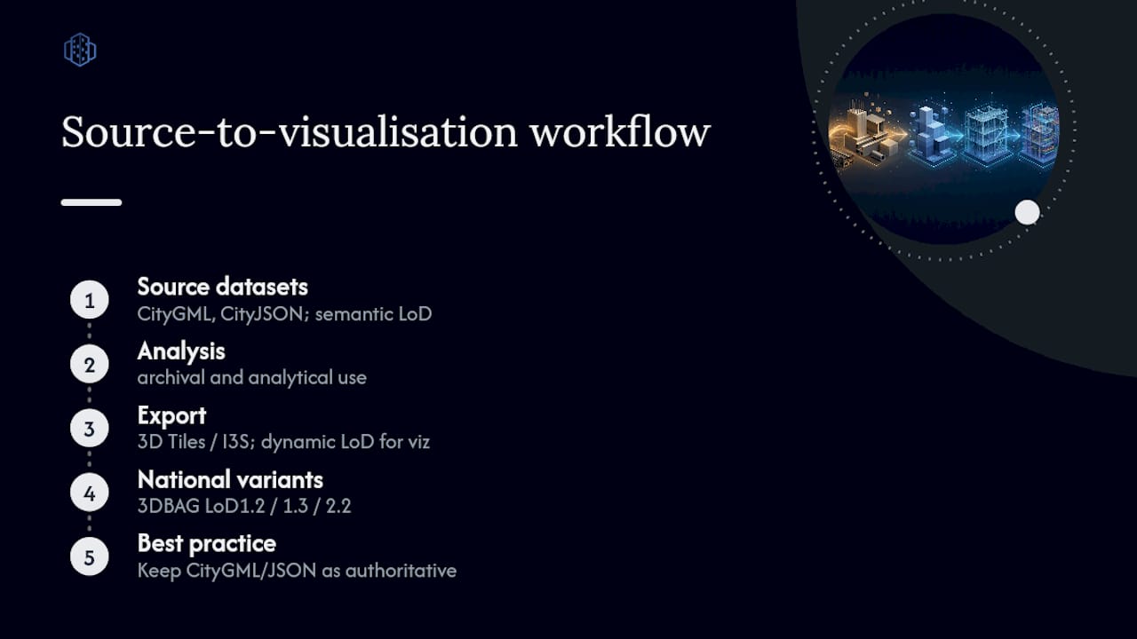
National providers add another layer of variation. In the Netherlands, 3DBAG publishes LoD1.2, LoD1.3 and LoD2.2 variants specifically to manage file size and semantic completeness across a country-scale dataset. Anyone importing 3DBAG tiles alongside a locally commissioned LoD2 model needs to check which sub-level applies, or the two datasets will not compare cleanly.
Does a higher LoD number guarantee better results?
No, and this is where a lot of specification documents go wrong. Research from TU Delft found that a detailed LoD2 or LoD3 model with poor positional accuracy can produce shadow analysis results no better than a simple block model, while a low-LoD dataset built from accurate source data can outperform a high-LoD model built on loose survey inputs.
A low-LoD model with higher positional accuracy may outperform a high-LoD model with poor accuracy, especially in shadow-casting and massing analyses where footprint precision is critical.
The practical rule follows directly: specify both the LoD number and the required positional and vertical accuracy in the same clause. Automated reconstruction from aerial LiDAR is fast and consistent across large areas but can smooth over small roof features; manual capture from architectural drawings is slower but far more precise for individual buildings under detailed review.
How do you write LoD into a tender or data contract?
A vague LoD reference is one of the most common causes of rejected deliveries. Cover these points explicitly:
- State the exact LoD number and the geometry type expected (footprint,
Solid, orMultiSurface) - List required semantic attributes, such as
bldg:measuredHeight,bldg:storeys, roof type andgml:id - Specify horizontal and vertical accuracy tolerances, not just the LoD label
- Name the accepted acquisition methods (LiDAR, photogrammetry, BIM extraction, manual survey)
- Confirm the delivery format (CityGML, CityJSON) and request a small sample tile before full delivery
Watch for red flags such as “LoD2-like” or “visual LoD” appearing in a supplier’s proposal without any accompanying accuracy figure or geometry definition. Those phrases usually mean the supplier has not decided what they are actually delivering.
Pro Tip: Always request one sample tile covering a mixed block, flat roofs, pitched roofs and at least one irregular building, before signing off on a full dataset. It surfaces geometry and accuracy issues in minutes rather than after the invoice arrives.
How does a digital twin help you test LoD choices before committing?
Comparing LoD1 massing against LoD2 roof detail is far easier when you can load both into the same 3D city model environment and run the same sunlight or visibility test on each. Some digital twin platforms let planners load competing datasets, run scenario comparisons side by side, and see where LoD or accuracy differences change an outcome before a tender is issued. That kind of rapid testing reduces procurement risk considerably, because you catch a mismatched specification before signing a contract for the wrong dataset.
The research says accuracy beats resolution, most tenders still ignore it
The evidence is fairly blunt: nominal LoD is a weak predictor of analytical usefulness on its own. What the Biljecki research actually demonstrates is that accuracy and acquisition quality carry more weight than the LoD label most tenders fixate on. Yet the majority of specifications still request “LoD2” or “LoD3” as if the number alone guarantees fitness for purpose.
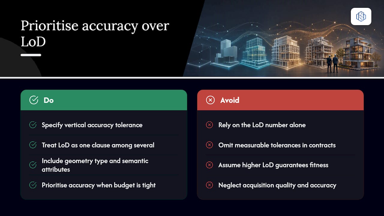
That gap between what a label promises and what a dataset actually delivers is where most procurement disputes originate. A planning department that specifies LoD2 without a vertical accuracy tolerance has, in practice, specified nothing measurable. The supplier can deliver something technically labelled LoD2 that is useless for shadow studies, and both parties will have followed the letter of the contract.
My honest recommendation: stop treating LoD as a single number to negotiate and start treating it as one clause among several, alongside accuracy, geometry type, and semantic attributes. Prioritise the accuracy figure first when budgets are tight, because a precise LoD1 model will usually beat an imprecise LoD3 model for most planning decisions.
— Anne Dullemond
Try before you specify: validating LoD choices in a live scenario
Specifying LoD in a contract is easier when you have already seen the trade-offs play out. Some urban planning platforms provide a browser-based way to load competing LoD datasets side by side and run sunlight, visibility or massing tests on each, without waiting on procurement to conclude first.
The demo walks through comparing LoD1 and LoD2 building sets against real terrain and GIS layers, running a shadow or visibility analysis on both, and exporting sample tiles that can go straight into a tender document. For a planner drafting a specification, that turns an abstract accuracy clause into a dataset you have actually tested. Start a trial through the urban design platform and compare your own LoD candidates before you commit budget to either one.
Sources
- Wegwijzer 3D standaarden (CityGML / CityJSON guidance)
- The level of detail of 3D geo-information (TU Delft / Biljecki)
- 3DBAG concepts and LoD variants
FAQ
What Is LoD in 3D City Modelling?
LoD, or Level of Detail, measures how much geometric and semantic information a building model contains, ranging from LoD0 footprints to LoD4 interior detail under the CityGML and CityJSON standards.
Is LoD the Same as the AIA’s LOD100–LOD500 Scale?
No. CityGML’s LoD describes city-scale geometric and semantic detail, while the AIA’s hundred-series LOD describes development maturity of individual BIM elements within a single building project.
Which LoD Is Best for Sunlight and Shadow Analysis?
LoD2 with accurate roof geometry is generally the minimum needed, since flat versus pitched roofs materially change shadow-casting results.
Does a Higher LoD Always Mean More Accurate Results?
No. TU Delft research shows a low-LoD model with high positional accuracy can outperform a high-LoD model built on inaccurate source data.
What Should a LoD Specification Include Besides the Number?
It should state geometry type, required semantic attributes such as bldg:measuredHeight, positional and vertical accuracy tolerances, accepted acquisition methods, and the delivery format.


