Urban project optimisation with advanced 3D tools in 2026

Urban project optimisation has long relied on fragmented manual processes that struggle to balance competing priorities, from sustainability targets to user satisfaction. Today, advanced 3D digital twin platforms and multi-objective optimisation algorithms are transforming how planners, architects, and developers approach complex urban challenges. These tools integrate real-time data, simulate countless scenarios, and enable collaborative decision-making that traditional methods simply cannot match. By embracing data-driven frameworks, urban professionals can achieve measurable improvements in energy efficiency, spatial coordination, and stakeholder alignment whilst navigating the intricate demands of modern cities in 2026.
Table of Contents
- Understanding Urban Project Optimisation And Its Challenges
- Integrating Generative Design And Multi-Objective Optimisation For Sustainable Districts
- Enhancing Spatial Coordination And User Satisfaction Through Advanced Optimisation
- Leveraging 3D Digital Twin Tools For Collaborative Urban Project Optimisation
- Explore Advanced 3D Cityplanner Tools For Your Urban Projects
Key takeaways
| Point | Details |
|---|---|
| Multi-objective optimisation balances competing goals | Integrates sustainability, user satisfaction, and spatial quality simultaneously for superior outcomes. |
| Digital twins enable real-time collaboration | Stakeholders visualise scenarios, test alternatives, and refine designs iteratively with transparent data. |
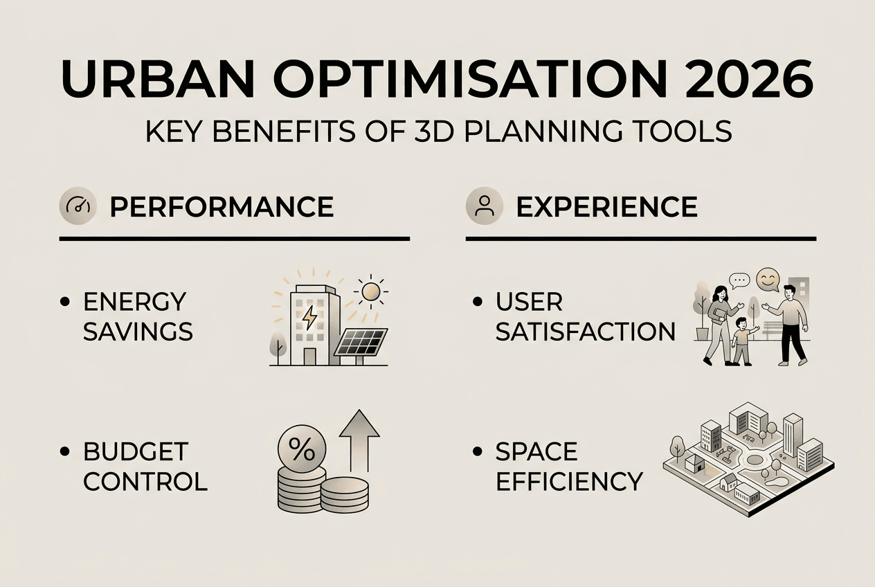
| Quantifiable performance gains | Energy use drops by up to 99 kWh/m²/year, user satisfaction rises 32.8%, and safety risks fall 63.2%. |
| Closed-loop feedback drives continuous improvement | Behaviour data and user input feed back into models, ensuring designs evolve with actual usage patterns. |
Understanding urban project optimisation and its challenges
Urban project optimisation means simultaneously balancing multiple competing objectives: environmental sustainability, economic viability, social equity, and spatial functionality. Unlike single-goal approaches that prioritise one element, such as maximising green space or minimising construction costs, true optimisation seeks the best compromise across all dimensions. This holistic perspective acknowledges that urban environments are complex systems where design decisions ripple through interconnected layers of infrastructure, community needs, and regulatory constraints.
Traditional humanistic design often stumbles by focusing on specific design elements whilst ignoring conflicts between diverse user needs. A plaza designed for aesthetic appeal might fail to accommodate accessibility requirements, whilst a transit hub optimised for throughput could neglect pedestrian comfort. These pitfalls arise because conventional methods lack unified metrics to measure trade-offs objectively. Planners rely on subjective judgement, stakeholder consultations that surface conflicting demands, and iterative revisions that consume time without guaranteeing optimal outcomes.
Several technical bottlenecks compound these challenges:
- Absence of standardised performance indicators across sustainability, safety, and user experience dimensions
- Poor integration of dynamic behaviour data, treating human activity as static rather than evolving
- Limited feedback loops connecting post-occupancy observations back into design refinement processes
- Siloed tools that prevent seamless collaboration between architects, engineers, planners, and community representatives
Without addressing these gaps, urban projects risk suboptimal spatial strategies that disappoint users, exceed budgets, or fail environmental targets. Recognising these limitations sets the stage for exploring how advanced optimisation technologies overcome them.
Pro tip: Treat user behaviour as a dynamic component, not a static input. Incorporate real-time occupancy patterns, movement flows, and activity preferences to design spaces that adapt sustainably over time.
Advanced digital urban planning platforms now integrate multi-objective algorithms with spatial analytics, enabling planners to visualise trade-offs, test alternatives, and converge on solutions that satisfy diverse criteria simultaneously.
Integrating generative design and multi-objective optimisation for sustainable districts
Generative design leverages artificial intelligence to produce hundreds or thousands of design alternatives based on defined parameters and constraints. Instead of manually sketching options, planners input goals such as target energy consumption, desired floor area ratios, and connectivity requirements. The algorithm then generates diverse configurations, each representing a different balance of priorities. This approach accelerates exploration and surfaces innovative solutions that human designers might overlook.
Multi-objective optimisation takes generative design further by systematically evaluating alternatives against competing metrics: carbon emissions, energy efficiency, construction costs, spatial quality, and user satisfaction. Rather than selecting a single “best” design, the process identifies a Pareto frontier, a set of solutions where improving one objective necessarily worsens another. Decision-makers can then choose the trade-off that aligns with project priorities, informed by transparent data rather than guesswork.
Research demonstrates tangible benefits. Integrating generative design and multi-objective optimisation within digital twin frameworks reduces energy use intensity by up to 99 kWh/m²/year and supports onsite generation reaching 42.5 kWh/m²/year. These reductions stem from optimised building orientations, facade designs that maximise passive solar gain, and integrated renewable energy systems calibrated to local climate data.

| Metric | Baseline scenario | Optimised scenario | Improvement |
|---|---|---|---|
| Energy use intensity | 180 kWh/m²/year | 81 kWh/m²/year | 99 kWh/m²/year reduction |
| Onsite energy generation | 0 kWh/m²/year | 42.5 kWh/m²/year | 42.5 kWh/m²/year increase |
| Net energy demand | 180 kWh/m²/year | 38.5 kWh/m²/year | 78.6% reduction |
These metrics illustrate how data-driven frameworks transform abstract sustainability goals into concrete, measurable outcomes. By testing thousands of configurations rapidly, planners identify strategies that achieve carbon neutrality targets without compromising spatial quality or economic feasibility.
Pro tip: Validate generative design outputs against carbon neutrality goals early in the planning process. Use digital twin simulations to test energy performance under diverse climate scenarios, ensuring resilience as conditions evolve.
Digital twin technology provides the real-time data infrastructure needed to continuously refine optimisation models. Sensor networks, building management systems, and IoT devices feed actual performance data back into simulations, enabling iterative improvements that keep projects aligned with evolving sustainability standards.
Enhancing spatial coordination and user satisfaction through advanced optimisation
Beyond environmental metrics, urban project optimisation addresses social and experiential dimensions by integrating user preferences, spatial indicators, and behavioural simulation. Traditional planning often treats these factors as secondary considerations, addressed through public consultations that surface opinions but lack rigorous quantification. Advanced optimisation models change this by embedding user data directly into the design process.
Multi-objective optimisation frameworks combine preference surveys, spatial analytics such as visibility and accessibility indices, and agent-based behavioural simulations that model how people navigate and interact within spaces. This integration reveals conflicts invisible to conventional methods. For example, a design maximising visual openness might inadvertently create safety concerns in poorly lit areas, whilst a layout optimised for pedestrian flow could neglect quiet zones for social interaction.
Quantifiable improvements validate this approach. Studies show that multi-objective optimisation improves weighted satisfaction by 32.8%, reduces safety risks by up to 63.2%, and increases interaction promotion by 71.2%. These gains stem from balancing competing user needs rather than prioritising singular design elements.
| Performance indicator | Before optimisation | After optimisation | Change |
|---|---|---|---|
| Weighted user satisfaction | Baseline | +32.8% | Significant improvement |
| Safety risk index | Baseline | -63.2% | Substantial risk reduction |
| Interaction promotion | Baseline | +71.2% | Enhanced social engagement |
Spatial coordination benefits extend across multiple dimensions:
- Reduced conflicts between pedestrian, cyclist, and vehicular movements through optimised pathway layouts
- Increased community engagement via strategically positioned gathering spaces that balance accessibility and comfort
- Safer environments through lighting, sightline, and surveillance optimisation informed by crime prevention research
- Enhanced inclusivity by integrating accessibility requirements directly into spatial optimisation algorithms
These outcomes demonstrate that data-driven optimisation transcends technical efficiency, addressing the human experience that ultimately determines whether urban spaces succeed or fail. By quantifying subjective factors such as comfort, safety, and social interaction, planners can make evidence-based trade-offs that satisfy diverse stakeholder priorities.
Pro tip: Prioritise balanced user needs to avoid local optima in design outcomes. A solution that maximises one user group’s satisfaction whilst neglecting others may appear optimal numerically but fail in practice.
Digital twin urban planning platforms enable continuous monitoring of user behaviour post-occupancy, feeding real-world data back into optimisation models. This closed-loop approach ensures designs evolve with actual usage patterns rather than remaining static based on initial assumptions.
Leveraging 3D digital twin tools for collaborative urban project optimisation
3D digital twin platforms provide the technological foundation for translating optimisation theory into practice. These tools create virtual replicas of urban environments, integrating spatial geometry, real-time sensor data, and simulation capabilities within a unified interface. Unlike traditional CAD software that represents static designs, digital twins dynamically update as conditions change, enabling stakeholders to explore scenarios, test interventions, and observe projected outcomes before committing resources.
Key features distinguish advanced digital twin tools:
- Visual modelling that renders buildings, infrastructure, and landscapes in photorealistic 3D, facilitating intuitive understanding across technical and non-technical audiences
- Real-time data integration from IoT sensors, traffic systems, energy networks, and environmental monitors, ensuring simulations reflect current conditions
- Scenario testing that allows planners to compare alternatives side by side, adjusting parameters such as building heights, land use mixes, and transportation networks to observe ripple effects
- Collaborative workspaces where architects, engineers, planners, and community representatives contribute simultaneously, reducing coordination friction and accelerating consensus
Implementing collaborative optimisation workflows involves structured steps:
- Define project objectives and constraints, translating stakeholder priorities into quantifiable metrics such as energy targets, cost limits, and user satisfaction thresholds.
- Build the digital twin model, importing existing site data, regulatory boundaries, and environmental baselines to establish the optimisation context.
- Generate design alternatives using generative algorithms, producing diverse configurations that explore the solution space comprehensively.
- Evaluate alternatives through multi-objective optimisation, ranking options based on performance across sustainability, user experience, and economic criteria.
- Facilitate stakeholder review sessions within the digital twin environment, enabling transparent comparison and informed decision-making.
- Refine selected designs iteratively, incorporating feedback and testing sensitivity to assumptions such as future population growth or climate scenarios.
- Monitor post-implementation performance, feeding real-world data back into the digital twin to validate predictions and inform future projects.
Collaborative benefits include:
- Improved transparency as all stakeholders access the same data and visualisations, reducing misunderstandings and political friction
- Iterative refinements enabled by rapid simulation cycles that test adjustments without physical prototyping costs
- Stakeholder alignment achieved through shared understanding of trade-offs, fostering consensus around optimal compromises
The closed-loop adjustment mechanism represents a paradigm shift. Traditional planning treats design as a linear process: research, design, build, occupy. Digital twins introduce continuous feedback, where occupancy data such as movement patterns, energy consumption, and user surveys flow back into the model. Algorithms identify discrepancies between predicted and actual performance, highlighting areas for improvement. Planners then adjust designs, test modifications in the digital twin, and implement changes with confidence grounded in evidence.
Digital twin city platforms integrate these capabilities within user-friendly interfaces, democratising access to advanced optimisation tools. Urban planning AI tools automate routine tasks such as code compliance checking and infrastructure sizing, freeing professionals to focus on strategic decisions that shape urban futures.
Explore advanced 3D Cityplanner tools for your urban projects
Urban planners, architects, and developers seeking to harness the optimisation strategies discussed can explore practical applications through 3D Cityplanner’s demo platforms. These tools translate research insights into accessible interfaces designed for real-world project workflows, enabling teams to test data-driven approaches without extensive technical training.
3D Cityplanner’s demo registration provides hands-on experience with generative design, multi-objective optimisation, and digital twin capabilities tailored for urban projects. The digital twin city platform integrates real-time data visualisation, scenario simulation, and collaborative tools that streamline stakeholder engagement. Meanwhile, the structure planner tool focuses on spatial layout optimisation, balancing land use, connectivity, and environmental performance within regulatory constraints. By experimenting with these platforms, professionals can validate optimisation benefits within their specific project contexts, improving decision-making, achieving sustainable outcomes, and enhancing collaboration efficiency across diverse teams in 2026.
FAQ
What distinguishes multi-objective optimisation from traditional urban planning?
Traditional planning often prioritises single goals sequentially, such as maximising density then addressing sustainability separately, leading to suboptimal trade-offs. Multi-objective optimisation simultaneously balances competing criteria, identifying solutions where improving one objective necessarily worsens another, then selecting the best compromise based on transparent data. This approach surfaces design alternatives that traditional methods overlook, achieving superior overall performance across environmental, social, and economic dimensions.
How do 3D digital twins improve collaboration among stakeholders?
Digital twin technology creates shared virtual environments where architects, engineers, planners, and community representatives visualise designs, test scenarios, and observe projected outcomes together. This transparency reduces misunderstandings, as all parties access identical data and simulations. Stakeholders contribute feedback directly within the platform, enabling iterative refinements without lengthy coordination cycles. The result is faster consensus, reduced political friction, and designs that reflect diverse priorities more effectively than siloed traditional processes.
Can urban project optimisation support carbon neutrality goals realistically?
Yes, research demonstrates that integrating generative design and multi-objective optimisation within digital twin frameworks reduces energy use intensity by up to 99 kWh/m²/year whilst supporting onsite generation reaching 42.5 kWh/m²/year. These reductions stem from optimised building orientations, facade designs maximising passive solar gain, and renewable energy systems calibrated to local climate data. By testing thousands of configurations rapidly, planners identify strategies achieving carbon neutrality targets without compromising spatial quality or economic feasibility, making ambitious environmental goals practically attainable.
What key data inputs enhance the effectiveness of spatial optimisation?
Effective spatial optimisation requires diverse data streams: user preference surveys quantifying comfort, safety, and interaction priorities; spatial indicators such as visibility, accessibility, and connectivity indices; behavioural simulations modelling how people navigate and use spaces; environmental baselines including climate, topography, and existing infrastructure; and regulatory constraints defining permissible land uses, heights, and densities. Integrating these inputs enables algorithms to balance competing objectives comprehensively, surfacing design alternatives that satisfy technical, social, and environmental criteria simultaneously whilst remaining compliant with planning regulations.
How frequently should urban projects be adjusted using optimisation feedback?
Optimisation feedback should inform projects continuously throughout their lifecycle. During planning, iterative refinements occur as stakeholders review alternatives and adjust priorities. Post-implementation, digital twins monitor real-world performance through sensor data, occupancy patterns, and user surveys, comparing actual outcomes against predictions. Significant discrepancies trigger reviews, where planners test modifications in the digital twin before implementing changes. This closed-loop approach ensures designs evolve with actual usage patterns, maintaining alignment with sustainability targets, user satisfaction goals, and operational efficiency standards as conditions change over time.
Recommended
- Master urban space modelling with advanced 3D tools in 2026 – 3D Urban Development
- Urban Development Workflow for Efficient 3D Planning – 3D Urban Development
- 3D Urban Development – Where data, 3D and urban design come together
- Urban planning workflow explained: optimise projects in 2026 – 3D Urban Development


