Urban infrastructure planning guide for advanced 3D optimisation

Coordinating complex urban infrastructure projects often leads to costly clashes, data silos, and workflow inefficiencies that delay delivery and inflate budgets. Traditional 2D methods struggle to integrate subsurface utilities, building information, and geospatial datasets into a cohesive planning framework. Advanced 3D technologies like Building Information Modelling, LiDAR scanning, ground-penetrating radar, and digital twins offer urban planners, architects, and developers practical solutions to optimise accuracy, enhance collaboration, and streamline decision-making across project lifecycles.
Table of Contents
- Key takeaways
- Understanding urban infrastructure challenges and 3D technology prerequisites
- Preparing your urban infrastructure project for 3D integration
- Executing 3D integrated workflows for urban infrastructure optimisation
- Verifying outputs and troubleshooting common challenges
- Discover 3D Cityplanner solutions to enhance your projects
- Frequently asked questions
Key Takeaways
| Point | Details |
|---|---|
| Selective BIM integration | Many urban infrastructure projects adopt BIM alongside existing 2D workflows to reduce disruption and realise targeted efficiency gains. |
| 3D subsurface mapping | Combining LiDAR with ground penetrating radar enhances subsurface accuracy and lowers risk from buried utilities. |
| Interoperability barriers persist | Open standards and interoperable platforms help prevent vendor lock in and support cross discipline collaboration. |
| Incremental 3D adoption | Organisations adopt 3D technologies gradually to supplement 2D workflows, pilot small projects, and build internal capability before full transformation. |
Understanding urban infrastructure challenges and 3D technology prerequisites
Urban infrastructure projects face persistent coordination difficulties stemming from fragmented data sources, incompatible file formats, and reliance on legacy 2D drawings. Multiple stakeholders—planners, engineers, utility providers, contractors—often work with disparate datasets that fail to communicate seamlessly. This heterogeneity increases the risk of design clashes, rework, and schedule overruns. Subsurface utilities remain particularly problematic because traditional survey methods provide limited spatial accuracy, leading to costly excavation surprises and safety incidents.
Building Information Modelling represents a structured approach to creating digital representations of physical and functional characteristics. Unlike static CAD drawings, BIM models embed semantic data about materials, dimensions, and relationships between building elements. LiDAR (Light Detection and Ranging) uses laser pulses to capture precise three-dimensional point clouds of existing conditions, enabling accurate as-built documentation and terrain modelling. Ground-penetrating radar penetrates soil to detect buried pipes, cables, and voids without excavation. Digital twins extend these technologies by creating dynamic virtual replicas that update with real-time sensor data, supporting predictive maintenance and scenario analysis.
Successful adoption requires more than purchasing software licences. Leadership commitment drives organisational change, allocating budgets for training, hardware upgrades, and process redesign. Skilled personnel who understand both domain knowledge and digital tools are essential—planners must interpret point cloud data, engineers must validate BIM geometry, and project managers must coordinate interdisciplinary workflows. Interoperable software platforms that exchange data via open standards like IFC (Industry Foundation Classes) and CityGML prevent vendor lock-in and enable seamless collaboration.
Many organisations adopt 3D technologies incrementally rather than abandoning established 2D workflows entirely. BIM adoption in Vietnam urban infrastructure demonstrates selective integration where BIM supplements conventional drawings for specific project phases or components. This pragmatic approach reduces disruption whilst building internal capabilities. Recognising that full transformation takes time allows teams to pilot technologies on smaller projects, refine processes, and demonstrate value before scaling.
Preparing your project environment begins with assessing current workflows to identify pain points where 3D technologies deliver maximum impact. Evaluate team competencies through skills audits and prioritise training gaps. Establish clear objectives for technology adoption—whether improving clash detection, accelerating approvals, or enhancing stakeholder visualisation—to measure success and justify investment. Explore urban infrastructure mapping with 3D and 4D tech to understand how integrated approaches transform planning accuracy.
Pro Tip: Conduct a pilot project on a manageable infrastructure component to test workflows, identify challenges, and build team confidence before committing to organisation-wide deployment.
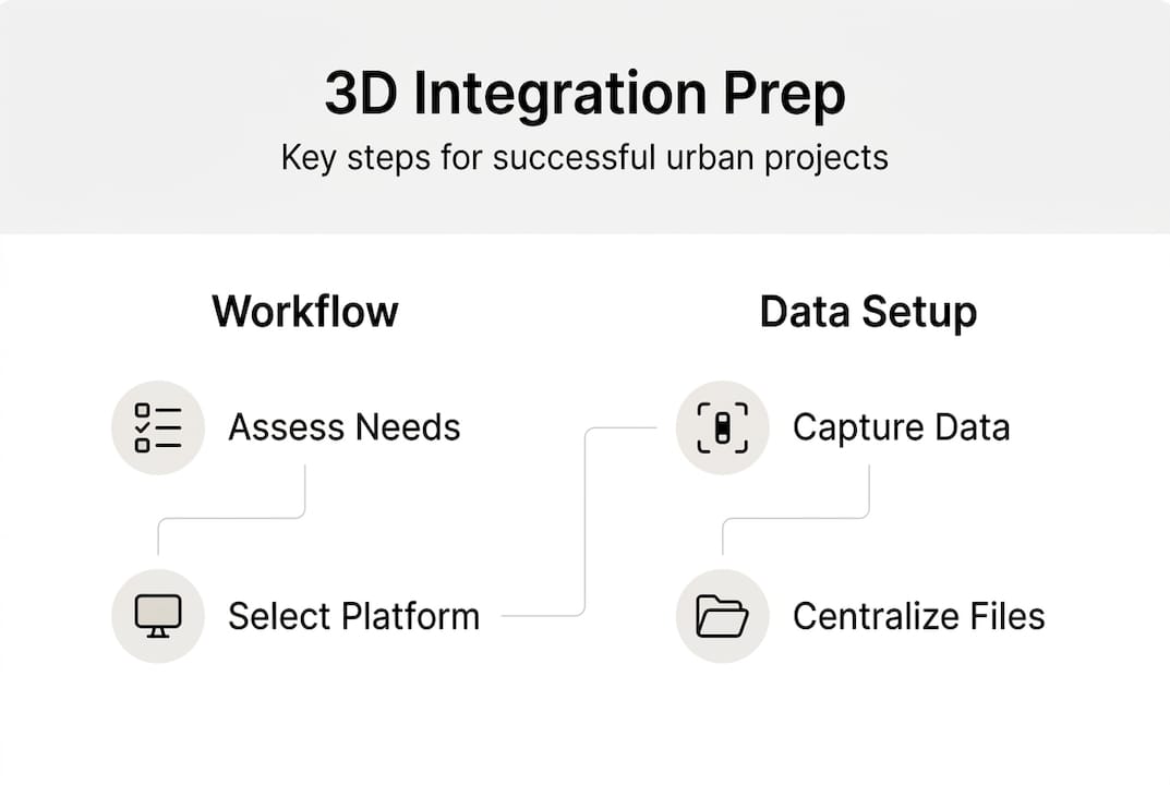
Preparing your urban infrastructure project for 3D integration
Effective preparation ensures your team and systems are ready to leverage 3D technologies without disrupting ongoing operations. Begin by assessing workforce skills across disciplines. Identify who needs training in BIM authoring software like Revit or ArchiCAD, point cloud processing tools such as CloudCompare or Leica Cyclone, and GIS platforms including ArcGIS or QGIS. Targeted training programmes tailored to role-specific needs accelerate competency development whilst avoiding information overload.
Selecting suitable software platforms requires balancing functionality, interoperability, and budget constraints. Choose BIM authoring tools that support open standards for data exchange. Integrate GIS capabilities to incorporate municipal datasets, zoning boundaries, and infrastructure networks. Point cloud processing software must handle large LiDAR datasets efficiently and export formats compatible with your BIM environment. Cloud-based collaboration platforms enable distributed teams to access current models, reducing version control issues and improving coordination.
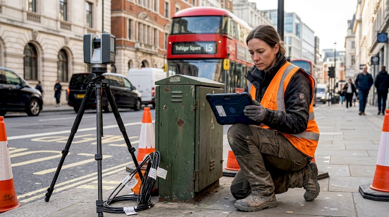
Defining data acquisition methods early prevents costly rework. Mobile Mapping Systems equipped with LiDAR scanners capture streetscapes, facades, and roadway geometry rapidly whilst maintaining sub-centimetre accuracy. Terrestrial laser scanning provides detailed interior and exterior documentation for complex structures. Photogrammetry offers cost-effective alternatives for projects with moderate accuracy requirements. 3D utility mapping uses GPR and LiDAR for accuracy but faces cost and skill barriers, highlighting the importance of budget planning and operator training when implementing subsurface detection technologies.
Creating a clear project plan maps 3D integration phases to project milestones. Identify which deliverables benefit most from 3D workflows—perhaps utility coordination during design development or construction sequencing during execution. Allocate resources for data capture, model development, and quality assurance. Establish review protocols where stakeholders validate models against project requirements and site conditions. Define roles and responsibilities to avoid confusion about who maintains model accuracy and resolves clashes.
Starting with pilot projects builds organisational capability incrementally. Select a project component with manageable complexity and clear success criteria. Document lessons learned, refine workflows, and share outcomes with broader teams. This iterative approach reduces risk whilst demonstrating tangible benefits that justify further investment. Explore efficient 3D planning workflow strategies to streamline your preparation phase.
Pro Tip: Establish a centralised data repository with version control and access permissions to prevent conflicting model updates and ensure all stakeholders work from current information.
Executing 3D integrated workflows for urban infrastructure optimisation
Implementing 3D integrated workflows transforms how urban infrastructure projects progress from concept through construction and operation. A systematic approach ensures technologies deliver measurable improvements in accuracy, coordination, and efficiency.
- Data capture and validation: Deploy mobile mapping systems or terrestrial scanners to capture existing conditions with precision. Validate point cloud accuracy using ground control points surveyed with GPS or total stations. Clean point clouds by removing noise, vegetation, and transient objects. Register multiple scans into a unified coordinate system aligned with project datums.
- Model integration and harmonisation: Import point clouds into BIM authoring software and create semantic models representing infrastructure elements. Apply BIM and CityGML standards to ensure consistent object classification and attribute schemas. Integrate municipal GIS datasets containing utility networks, cadastral boundaries, and regulatory constraints. Harmonise coordinate reference systems across all data sources to prevent spatial misalignment.
- Clash detection and coordination: Run automated clash detection algorithms to identify geometric conflicts between proposed designs and existing infrastructure. Prioritise clashes by severity and assign resolution responsibilities to discipline leads. Conduct coordination meetings where stakeholders review clashes in immersive 3D environments, facilitating rapid consensus on design adjustments. Document resolutions and update models iteratively.
- Asset monitoring and maintenance planning: Deploy digital twin frameworks that integrate real-time sensor data with BIM models. BIM-based digital twin framework for urban roads with MMS LiDAR achieves geometric accuracy with RMSE ≤0.131m, enabling precise defect detection and predictive maintenance scheduling. Configure dashboards that visualise asset condition, performance metrics, and maintenance histories to support data-driven decision-making.
The table below compares data capture methods commonly used in urban infrastructure projects:
| Method | Accuracy | Coverage Speed | Typical Applications | Cost Considerations |
|---|---|---|---|---|
| Mobile Mapping System LiDAR | 1-3 cm | High (km/hour) | Road corridors, streetscapes, utility mapping | High equipment cost, moderate processing time |
| Terrestrial Laser Scanning | 2-5 mm | Moderate (site-based) | Building facades, complex structures, interiors | Moderate equipment cost, labour-intensive setup |
| Photogrammetry | 1-10 cm | Variable | Large areas, aerial surveys, visual documentation | Low equipment cost, processing-intensive |
| Ground-Penetrating Radar | 5-15 cm | Moderate (linear surveys) | Subsurface utility detection, pavement assessment | Moderate cost, requires skilled interpretation |
Emphasise incremental BIM deployment alongside conventional 2D drawings during transition periods. Many project teams maintain parallel workflows where BIM models inform critical coordination decisions whilst 2D deliverables satisfy contractual requirements and stakeholder familiarity. This hybrid approach reduces resistance and allows gradual capability building. Validate semantic 3D models regularly to address redundancies that accumulate in complex infrastructure projects, ensuring model performance and usability remain optimal.
Explore digital twin urban planning applications and urban project optimisation with advanced 3D tools to deepen your understanding of integrated workflows.
Pro Tip: Schedule regular model audits where independent reviewers verify geometric accuracy, semantic completeness, and data consistency to prevent error propagation through project phases.
Verifying outputs and troubleshooting common challenges
Verification ensures 3D integrated models meet accuracy standards and deliver reliable information for decision-making. Root Mean Square Error measurements quantify geometric accuracy by comparing model coordinates against surveyed reference points. Target RMSE thresholds depend on project requirements—infrastructure projects typically demand sub-decimetre accuracy whilst conceptual planning tolerates coarser precision. Clash detection logs provide quantitative metrics on coordination effectiveness, tracking clash counts, resolution rates, and recurring conflict patterns. Visual inspections by experienced professionals remain essential for identifying semantic errors, modelling inconsistencies, and usability issues that automated checks miss.
Common challenges include data heterogeneity where incompatible file formats, coordinate systems, and classification schemes hinder integration. Establishing data exchange protocols based on open standards mitigates this issue. Redundancy in complex structures occurs when overlapping model elements create file bloat and processing slowdowns. Regular model audits identify and remove duplicate geometry. Cost overruns stem from underestimating LiDAR acquisition expenses, software licensing fees, and training investments. Detailed budget planning with contingency reserves prevents financial surprises.
The comparison table below highlights differences between traditional 2D and advanced 3D BIM/digital twin workflows:
| Workflow Aspect | Traditional 2D | 3D BIM/Digital Twin |
|---|---|---|
| Initial setup cost | Low | Moderate to high |
| Geometric accuracy | ±10-50 cm typical | ±1-5 cm achievable |
| Clash detection capability | Manual, error-prone | Automated, comprehensive |
| Stakeholder visualisation | Limited, requires interpretation | Immersive, intuitive |
| Lifecycle data integration | Fragmented across documents | Centralised in digital model |
| Time to coordinate changes | Days to weeks | Hours to days |
| Maintenance planning support | Reactive, paper-based | Predictive, data-driven |
Bridge BIM maintenance with LiDAR and AI-based defect detection demonstrates enhanced identification capabilities whilst acknowledging IFC interoperability and cost barriers that require strategic planning to overcome.
Troubleshooting tips for successful implementation include:
- Align data formats early by standardising on open exchange protocols like IFC, CityGML, and LandXML across project stakeholders
- Train staff continuously through hands-on workshops, certification programmes, and peer mentoring to build sustained competency
- Plan budgets comprehensively by itemising hardware, software, training, and data acquisition costs with realistic contingencies
- Validate models iteratively at key project milestones rather than deferring quality assurance until project completion
- Document workflows systematically to capture institutional knowledge and streamline onboarding for new team members
- Engage stakeholders frequently through model reviews and immersive visualisations to maintain alignment and secure buy-in
Incremental adoption allows organisations to manage risk whilst building internal capabilities. Starting with pilot projects on manageable components demonstrates value, identifies process improvements, and builds confidence before scaling to larger initiatives. Continuous validation through RMSE measurements, clash detection audits, and stakeholder feedback ensures model reliability throughout project lifecycles. Explore digital twin technology in city planning to understand how verification practices support long-term asset management.
Discover 3D Cityplanner solutions to enhance your projects
Transforming urban infrastructure planning requires tools designed specifically for the complexities you face daily. 3D Cityplanner delivers integrated solutions that combine digital twin technology, structure planning capabilities, and urban development workflows into a unified platform. Whether you’re coordinating subsurface utilities, visualising project timelines with 4D planning, or optimising building placement for regulatory compliance, our tools streamline collaboration and improve decision accuracy.
Explore our 3D Cityplanner demo to experience how automated building generation, line-of-sight analysis, and noise impact simulation enhance project outcomes. Discover digital twin city solutions that integrate real-time data for predictive asset management. Leverage our structure planner tool to optimise infrastructure layouts and accelerate approvals. Trial periods require no upfront payment, allowing your team to evaluate functionality within actual project contexts before committing resources.
Frequently asked questions
What are the main barriers to BIM adoption in urban infrastructure?
Cost constraints, workforce skill gaps, and interoperability challenges between software platforms represent primary barriers. Organisational resistance to changing established 2D workflows and uncertainty about return on investment also slow adoption. Leadership commitment and incremental implementation strategies help overcome these obstacles.
How does LiDAR improve subsurface utility mapping accuracy?
LiDAR combined with ground-penetrating radar captures precise three-dimensional positions of buried utilities, reducing location uncertainty from metres to centimetres. This accuracy minimises excavation risks, prevents utility strikes, and improves coordination between surface designs and subsurface infrastructure.
What steps can ensure successful integration of digital twins in urban projects?
Start with clear objectives defining what asset data and performance metrics the digital twin must provide. Establish data governance protocols for sensor integration, model updates, and access permissions. Validate geometric accuracy against surveyed reference points and train staff on dashboard interpretation and maintenance workflows.
Can 3D technologies coexist with existing 2D workflows effectively?
Yes, incremental adoption allows 3D models to supplement 2D deliverables during transition periods. Teams use BIM for coordination and clash detection whilst maintaining 2D drawings for contractual compliance. This hybrid approach reduces disruption and builds capabilities progressively.
What are typical cost considerations when implementing 3D infrastructure planning?
Budget for LiDAR data acquisition, BIM software licences, point cloud processing tools, hardware upgrades, and workforce training. Pilot projects typically require £50,000-£150,000 depending on scope, whilst organisation-wide deployment scales proportionally. Long-term savings from reduced rework and improved coordination often justify initial investments within 2-3 project cycles.
Recommended
- Urban project optimisation with advanced 3D tools in 2026 – 3D Urban Development
- Urban Development Workflow for Efficient 3D Planning – 3D Urban Development
- Why optimise city planning: 3D tools for better design – 3D Urban Development
- Master urban infrastructure mapping with 3D and 4D tech – 3D Urban Development