Urban digital twins: enhance planning with virtual cities

TL;DR:Urban digital twins provide real-time, dynamic virtual models of city environments for better decision-making.Implementation involves phased development from descriptive to autonomous system levels, starting with pilot districts.They offer opportunities for monitoring, scenario planning, and cost savings, but face challenges like high costs and data privacy.
Static city maps and traditional 3D models have long been the backbone of urban planning, but they share a critical flaw: they freeze reality at a single point in time. Cities, by contrast, never stop moving. Traffic shifts, populations grow, climate risks intensify, and development pressures mount simultaneously. Urban digital twins address this gap directly, offering living simulation environments that mirror real-world conditions in real time. This guide explains what urban digital twins are, how the underlying technology works, how to implement them in phases, and what opportunities and constraints planners and developers should realistically expect.
Table of Contents
- What are urban digital twins?
- How urban digital twins work: Inside the technology
- From pilot to full-scale: How to implement urban digital twins
- Opportunities and limitations: What planners should know
- Future of urban digital twins: Trends and expert insights
- A planner’s perspective: What matters more than perfect predictions
Key Takeaways
| Point | Details |
|---|---|
| Dynamic city modelling | Urban digital twins go beyond visualisation by linking real-world data for real-time city simulation and optimisation. |
| Phased implementation | Start with small pilots and build up through maturity levels to full city-scale adoption for success. |
| Mind both benefits and limits | Digital twins offer scenario planning and monitoring but cannot predict all urban outcomes perfectly. |
| Future-forward technology | Upcoming trends like edge-core hybrids and AI will make twins more powerful and accessible. |
What are urban digital twins?
With the stage set, let’s define exactly what constitutes an urban digital twin and why it’s different from past approaches.
A digital twin city concept is not simply a prettier version of a GIS map or a static BIM model. It is a continuously updated virtual replica of a physical urban environment, fed by live data streams and capable of running simulations that inform real decisions. Think of it as a single source of truth for an entire city, one that reflects what is happening now and can model what might happen next.
Urban digital twins are dynamic virtual replicas of physical urban environments, integrating real-time data from IoT sensors, GIS, BIM, satellite imagery, and demographics to enable simulation, monitoring, and optimisation of city systems.
What separates digital twins from conventional modelling tools is the combination of continuous data ingestion and AI-driven analytics. Rather than a snapshot, you get a dynamic system. The key data types integrated include:
- IoT sensors: Real-time feeds from traffic counters, air quality monitors, energy metres, and flood sensors
- GIS layers: Spatial data covering land use, zoning, infrastructure networks, and topography
- BIM models: Detailed building-level data including structural, mechanical, and energy information
- Satellite imagery: Up-to-date aerial views for change detection and environmental monitoring
- Demographic and social data: Population movement, economic activity, and service demand patterns
For planners and developers, urban planning with digital twins means these layers combine to reflect reality with far greater fidelity than any static model can achieve. When you test a new transit corridor or assess flood risk for a proposed development, the twin draws on all these streams simultaneously, producing outputs grounded in actual urban conditions rather than assumptions.
How urban digital twins work: Inside the technology
Now that we’ve defined the concept, let’s unpack the technology that powers urban digital twins and the critical modules that make them work.
Core mechanics involve multi-layer architectures: data ingestion from IoT and GIS sources, edge and cloud processing, AI and machine learning for predictive modelling, 3D and 4D visualisation, and bidirectional feedback loops for scenario testing. Each layer has a distinct role.
| Technology layer | Role in the twin |
|---|---|
| IoT and sensor networks | Continuous real-world data collection |
| Edge and cloud computing | Processing and storage at scale |
| AI and machine learning | Pattern recognition and predictive analytics |
| 3D and 4D visualisation engines | Spatial and temporal representation |
| Feedback and simulation loops | Scenario testing and outcome modelling |
In practice, a digital twins city planning workflow might look like this:
- Data ingestion: Sensors, satellites, and administrative databases feed raw data into the system continuously
- Edge processing: Local computing nodes filter and pre-process data to reduce latency before sending it to the cloud
- AI analytics: Machine learning models identify trends, anomalies, and probable future states
- Visualisation: Planners interact with the twin through an intuitive 3D urban visualisation interface, viewing current conditions and simulated scenarios
- Scenario testing: Teams run what-if analyses, such as rerouting traffic after a new development or stress-testing energy grids during a heatwave
- Feedback loop: Outputs inform real-world decisions, and outcomes are fed back into the twin to improve future predictions
Pro Tip: When building your first digital twin, adopt a modular architecture from the outset. Start with the data layers most relevant to your immediate project needs, then add modules incrementally. This approach protects your initial investment and makes the system far easier to scale as your requirements grow.
From pilot to full-scale: How to implement urban digital twins
Understanding the tech is just one side. Let’s see what it takes to move from initial pilots to a robust city-wide twin.
Implementation methodologies emphasise phased approaches: start with descriptive models, progress to informative, predictive, comprehensive, and autonomous stages, piloting in districts before scaling to the full city. This maturity model gives teams clear milestones and prevents costly overreach.
| Maturity level | Description | Typical use case |
|---|---|---|
| Descriptive | Static or near-static representation | Baseline mapping and asset inventory |
| Informative | Real-time data integration | Monitoring infrastructure performance |
| Predictive | AI-driven forecasting | Traffic and energy demand modelling |
| Comprehensive | Full system integration | Cross-sector scenario planning |
| Autonomous | Self-optimising feedback | Adaptive city management |
A practical phased adoption model for planners and developers follows these steps:
- Define scope: Select a specific district or urban challenge as your pilot focus
- Audit data assets: Identify existing GIS, BIM, and sensor data that can seed the twin
- Build the descriptive layer: Establish the baseline model using available data sources
- Validate against reality: Cross-check twin outputs with observed conditions to calibrate accuracy
- Expand to informative and predictive layers: Integrate live data feeds and AI analytics
- Scale to adjacent districts: Apply lessons from the pilot before committing to city-wide deployment
This guide for urban planners approach is especially valuable when working on urban redevelopment with digital twins, where phased validation reduces financial and reputational risk.
Pro Tip: Involve both public agencies and private developers from the pilot stage. Shared governance structures and co-investment models dramatically improve data quality, reduce duplication, and build the trust needed for city-wide adoption.
Opportunities and limitations: What planners should know
Even as adoption grows, planners must keep in mind both the transformative possibilities and the inherent constraints of digital twins.
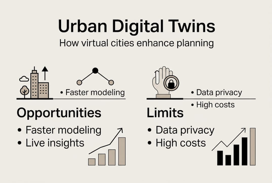
The opportunities are substantial. Real-time digital twin city monitoring allows planners to detect infrastructure stress before it becomes a crisis. Scenario planning tools let developers model the impact of a new mixed-use scheme on surrounding traffic, noise, and energy demand before a single brick is laid. Cost savings emerge from avoided mistakes and optimised resource allocation.
Key opportunities:
- Real-time monitoring of infrastructure, environment, and public services
- Scenario planning for development, climate resilience, and emergency response
- Improved stakeholder communication through intuitive visualisation
- Reduced project risk through evidence-based decision-making
- Long-term cost savings via optimised maintenance and resource use
However, the limitations are equally real. Edge cases include data silos, high compute costs, scalability challenges for real-time fidelity, integration of human behaviour and social dynamics, and applicability in resource-limited developing contexts requiring low-cost pilots.
Real-world constraints to anticipate:
- High upfront investment in sensors, software, and integration
- Data governance and privacy concerns, particularly around citizen-level data
- Fragmented data ownership across multiple agencies and operators
- Cities as complex emergent systems limit perfect prediction, as dispersed knowledge and social unpredictability mean twins excel in complicated subsystems like traffic but struggle with full social-spatial complexity
Understanding where digital twins revolutionise urban planning and where they fall short is essential for setting realistic expectations with clients, councillors, and communities.
Future of urban digital twins: Trends and expert insights
Urban digital twins are evolving rapidly. Here’s what urban planners and real estate developers should anticipate and prepare for.
Emerging trends shaping the next generation of urban digital twins:
- Edge-core hybrid models: Combining local edge computing with centralised cloud infrastructure to improve real-time responsiveness and reduce data transfer costs
- Generative AI integration: Using large language models and generative design tools to automate scenario creation and surface non-obvious planning options
- Blockchain for interoperability: Securing data sharing across city agencies, private operators, and national government systems
- Human-centric modelling: Capturing behavioural and social dynamics more accurately to improve the twin’s relevance for equity and inclusion planning
- Affordable, scalable implementations: Future trends point toward low-cost pilots designed for developing regions, ensuring digital twin benefits are not confined to wealthy cities
Statistic callout: Global digital twin adoption in cities is expected to double by 2028, driven by falling sensor costs, maturing AI platforms, and growing pressure to manage urban growth sustainably.
Risk mitigation remains critical. High initial costs, data privacy, and siloed governance are the most commonly cited barriers, and the most effective mitigation strategies centre on modular architectures, public-private collaboration, and hybrid physical-digital validation processes.
For planners investing in 3D visualisation tools today, choosing platforms that are built for modularity and interoperability is not just good practice. It is a form of future-proofing that will determine whether your twin remains relevant as the technology landscape shifts. Platforms that support digital twins innovation with open data standards will be far easier to upgrade and extend over time.
A planner’s perspective: What matters more than perfect predictions
With future technology in sight, here’s a grounded take on what truly helps planners and developers make the most of digital twin adoption.
The most persistent misconception about urban digital twins is that their value lies in prediction accuracy. It does not. Cities are not machines with knowable outputs. They are living systems shaped by politics, culture, economics, and individual human choices. Expecting a digital twin to forecast the future with precision is setting it up to disappoint.
The real value lies in scenario exploration and structured dialogue. When teams use a twin to ask
Recommended
- 5 Ways Digital Twins Are Revolutionizing Urban Planning - 3D Gebiedsontwikkeling
- 3D Cityplanner, Digital Twin City, Digital Twin Cities, Urban Development, data driven urban development, Geo design, Urban Planning - StrateGis | Groep
- What is a digital twin city? A guide for urban planners – 3D Urban Development
- Digital Twin Technology: Transforming City Planning Impact – 3D Urban Development