Role of 4D planning in urban projects for better outcomes

Urban development projects frequently encounter delays, cost overruns, and coordination failures that traditional planning methods struggle to prevent. These challenges stem from an inability to visualise how complex projects unfold over time, leaving teams reactive rather than proactive. 4D planning integrates scheduling with spatial models to address this gap, adding the critical dimension of time to three-dimensional representations. This article explores how 4D planning transforms urban project management, compares it with conventional 3D approaches, and provides practical guidance for implementation.
Table of Contents
- Understanding 4D Planning: What It Is And Why It Matters
- The Pivotal Role Of 4D Planning In Urban Projects: Benefits And Improvements
- Comparing 3D And 4D Planning: What Urban Projects Gain By Adding Time
- Applying 4D Planning In Practice: Key Steps And Considerations For Urban Projects
- Explore Advanced 4D Planning Solutions With 3D Cityplanner
Key takeaways
| Point | Details |
|---|---|
| Time integration | 4D planning extends 3D models by incorporating project schedules and construction sequences for dynamic visualisation. |
| Enhanced coordination | Teams identify clashes and dependencies early, reducing miscommunication and costly rework during construction phases. |
| Risk mitigation | Simulating project scenarios before execution helps anticipate bottlenecks and optimise resource allocation strategies. |
| Faster delivery | Projects using 4D planning achieve up to 25% faster completion compared to traditional 3D methods. |
| Stakeholder clarity | Visual timelines improve communication with investors, regulators, and community groups throughout project lifecycles. |
Understanding 4D planning: what it is and why it matters
4D planning represents the integration of three-dimensional spatial models with the fourth dimension of time, creating dynamic visualisations that show how construction progresses through sequential phases. Unlike static 3D representations that display only the final built form, digital urban planning with 4D capabilities reveals when each element appears, how long activities take, and which tasks depend on others completing first. This temporal layer transforms architectural and engineering models from beautiful renderings into actionable management tools.
Urban projects face unique complexities that make this temporal integration particularly valuable. Multiple stakeholders operate simultaneously across constrained sites, underground utilities require careful sequencing, and regulatory approvals often dictate specific construction windows. Traditional planning methods force teams to mentally overlay Gantt charts onto 3D models, creating cognitive gaps where coordination failures breed. 4D planning eliminates this disconnect by fusing schedule data directly into the spatial environment.
The practical benefits extend beyond mere visualisation. When you link construction activities to geometric elements, the model becomes a testing ground for different sequencing strategies. You can simulate whether demolishing an existing structure before completing utility relocations creates access problems, or whether phasing residential towers before commercial spaces optimises cash flow. These insights emerge naturally from the integrated model rather than requiring separate analysis.
Pro Tip: Introduce 4D planning during schematic design rather than waiting until construction documentation, allowing early detection of sequencing conflicts when design changes remain inexpensive and straightforward.
Key aspects that distinguish 4D planning include:
- Direct linkage between schedule tasks and 3D model components
- Automated visualisation of construction progress over time
- Identification of spatial conflicts that only appear during specific phases
- Resource allocation tracking tied to physical locations
- Integration with project management platforms for real-time updates
The technology works by assigning temporal attributes to every element in a building information model. A concrete foundation might carry a start date of 15 March 2026 and duration of three weeks, whilst the steel frame above it begins on 5 April 2026. The software then generates animations showing these elements appearing in sequence, revealing whether crane positions accommodate both activities or whether temporary structures obstruct access routes.
The pivotal role of 4D planning in urban projects: benefits and improvements
Urban development demands coordination across disciplines that traditional planning struggles to achieve, yet 4D simulation significantly enhances project coordination by making abstract schedules tangible and revealing dependencies that spreadsheets obscure. Architects, structural engineers, MEP consultants, and contractors each maintain their own timelines, creating fragmented views that miss critical overlaps. 4D planning synthesises these separate schedules into a unified visual narrative that everyone interprets identically.

The coordination benefits manifest most clearly during complex sequencing scenarios. Consider a mixed-use development where retail construction must complete before residential towers begin, yet both share underground parking that requires simultaneous excavation. A 4D model instantly shows whether the proposed schedule creates conflicts, whether temporary barriers adequately separate work zones, and whether material deliveries for different phases compete for limited staging areas. These insights prevent expensive field changes.
Risk management improves dramatically when teams simulate construction before breaking ground. You can test whether weather delays to the foundation work cascade through subsequent trades, evaluate whether accelerating the facade installation compensates for earlier setbacks, and determine which activities represent critical path vulnerabilities. This proactive approach replaces reactive crisis management with strategic contingency planning.
“Implementing 4D planning reduces coordination errors by 40% and decreases the likelihood of schedule overruns by identifying conflicts during the planning phase rather than discovering them on site.”
Stakeholder communication transforms when you replace technical drawings and abstract schedules with intuitive animations. Local councils grasp how construction impacts surrounding streets, investors understand when revenue-generating spaces become operational, and community groups visualise how disruption evolves over time. This transparency builds trust and facilitates approvals that might otherwise face opposition based on uncertainty.
Specific improvements 4D planning delivers include:
- Early clash detection between trades working in proximity
- Optimised equipment utilisation through spatial conflict analysis
- Reduced insurance claims from improved safety planning
- Faster regulatory approvals via clearer impact demonstrations
- Lower financing costs through more accurate completion forecasts
The technology also supports value engineering by revealing inefficiencies invisible in traditional planning. You might discover that resequencing mechanical installations eliminates three weeks of critical path time, or that adjusting the tower crane position reduces lifts by 200 cycles. These optimisations compound throughout long-duration urban projects, generating substantial time and cost savings.
Comparing 3D and 4D planning: what urban projects gain by adding time
Three-dimensional planning excels at spatial design, allowing teams to coordinate geometries, test aesthetic concepts, and identify physical clashes between building systems. However, it presents a static snapshot that assumes all elements exist simultaneously, missing the dynamic reality of phased construction where timing dictates feasibility. 4D planning offers up to 25% faster project delivery by adding the temporal intelligence that 3D alone cannot provide.
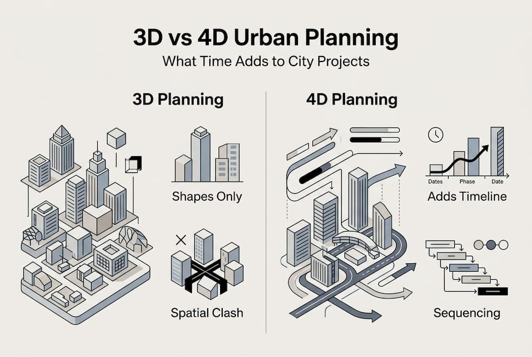
The fundamental limitation of 3D planning emerges when teams ask questions about sequence and duration. How long will excavation take given soil conditions and dewatering requirements? Can we install curtain wall panels whilst interior framing continues below? Does the proposed logistics plan accommodate overlapping deliveries during peak construction? Traditional 3D models remain silent on these critical questions, forcing planners to consult separate scheduling tools and mentally synthesise the information.
| Feature | 3D planning | 4D planning |
|---|---|---|
| Spatial coordination | Identifies geometric clashes between building components | Identifies geometric clashes and reveals timing-dependent conflicts |
| Schedule integration | Requires separate Gantt charts and manual correlation | Embeds schedule directly into spatial model for automatic visualisation |
| Risk analysis | Limited to design-phase spatial conflicts | Simulates construction sequences to identify temporal vulnerabilities |
| Stakeholder communication | Static renderings require technical interpretation | Animated sequences provide intuitive understanding of project progression |
| Resource planning | No connection between model and resource allocation | Links equipment, materials, and labour to specific locations and timeframes |
| Change management | Design changes require manual schedule updates | Model updates automatically reflect scheduling implications |
4D planning’s advantages become particularly pronounced in constrained urban environments where site logistics dominate project success. You can simulate whether proposed laydown areas remain accessible as structures rise, test whether crane coverage reaches all required lift points throughout construction, and verify that temporary utilities support peak demand periods. These spatial-temporal analyses prevent costly field improvisations.
The enhanced capabilities also support lean construction methodologies by visualising workflow continuity. Just-in-time delivery strategies require precise coordination between fabrication, transportation, and installation activities that 4D models make explicit. You can identify where buffers protect critical paths, where parallel work streams offer schedule compression opportunities, and where dependencies create bottlenecks requiring mitigation.
Pro Tip: Integrate 4D planning with building information modelling and digital twin technologies to create living models that update automatically as construction progresses, enabling real-time variance analysis and predictive scheduling.
Applying 4D planning in practice: key steps and considerations for urban projects
Successful implementation requires systematic approaches that align technical capabilities with organisational workflows, ensuring urban planning workflow optimisation delivers practical value rather than becoming a disconnected visualisation exercise. The following framework guides teams through adoption whilst avoiding common pitfalls that undermine 4D planning initiatives.
Implementation workflow:
- Establish data requirements and collection protocols for all project participants, ensuring 3D models include sufficient detail for construction sequencing analysis.
- Develop or refine the baseline construction schedule with input from all trades, breaking activities into granular tasks that map to discrete model elements.
- Link schedule activities to corresponding 3D components using unique identifiers, verifying that every geometric element carries temporal attributes.
- Generate initial 4D simulations and conduct cross-functional reviews to identify sequencing conflicts, resource constraints, and optimisation opportunities.
- Iterate the model based on team feedback, testing alternative sequences and documenting decisions that inform final construction planning.
- Integrate 4D outputs with project controls systems for ongoing monitoring, updating the model as actual progress deviates from baseline assumptions.
Data accuracy represents the foundation upon which 4D planning delivers value. Incomplete 3D models missing temporary works or unrealistic schedules ignoring site constraints produce misleading simulations that erode stakeholder confidence. Invest time validating inputs before generating visualisations, ensuring the model reflects constructible sequences rather than idealised assumptions.
Software compatibility challenges often emerge when teams use different platforms for design, scheduling, and project management. Establish data exchange protocols early, testing whether information flows smoothly between tools or requires manual intervention. Cloud-based platforms that support open standards like IFC and BCF typically offer superior interoperability compared to proprietary systems.
Common obstacles and mitigation strategies:
- Resistance from team members unfamiliar with 4D tools: Provide targeted training and demonstrate quick wins that illustrate immediate benefits
- Excessive time required for model updates: Automate data synchronisation between scheduling software and 3D platforms using API integrations
- Lack of clear ownership for 4D model maintenance: Assign dedicated resources with defined responsibilities and integrate updates into project milestones
- Insufficient detail in early-stage models: Develop phased modelling standards that balance detail with project phase, starting with massing studies and progressing to component-level precision
- Scepticism about return on investment: Track metrics like RFI reduction, change order frequency, and schedule variance to quantify 4D planning’s impact
Pro Tip: Host interactive 4D planning sessions where stakeholders manipulate the timeline themselves, adjusting sequencing and immediately seeing spatial implications, which builds intuitive understanding and generates collaborative problem-solving.
Skill development deserves particular attention since 4D planning requires hybrid expertise spanning design, construction, and scheduling domains. Identify team members with cross-disciplinary knowledge to champion adoption, then build broader capability through hands-on projects rather than abstract training. Real-world problem-solving accelerates learning more effectively than classroom instruction.
Explore advanced 4D planning solutions with 3D Cityplanner
Urban projects demand sophisticated tools that integrate spatial intelligence with temporal dynamics, and 3D Cityplanner delivers precisely this capability through its advanced 4D planning platform. The system combines automatic timeline generation with comprehensive building databases, enabling rapid model development that would require weeks using traditional methods. You can import existing 3D models, link them to construction schedules, and generate dynamic simulations that reveal optimisation opportunities.
The platform’s digital twin capabilities extend beyond planning into operational management, creating living models that evolve with your projects. Real-time data integration supports predictive analytics that anticipate delays before they cascade, whilst collaborative features ensure all stakeholders work from identical information. Whether you’re managing mixed-use developments, infrastructure upgrades, or urban regeneration schemes, 3D Cityplanner’s city planning tools provide the visualisation and analysis capabilities that transform complex projects into manageable, optimised delivery programmes.
Frequently asked questions
What is 4D planning in urban development?
4D planning combines three-dimensional spatial models with construction schedules to create dynamic visualisations showing how projects evolve over time. This integration allows teams to simulate building sequences, identify temporal conflicts, and optimise resource allocation before construction begins. The approach transforms static designs into actionable management tools that improve coordination across all project phases.
How does 4D planning improve project coordination?
By linking schedule activities directly to 3D model components, 4D planning makes abstract timelines tangible and reveals dependencies that spreadsheets obscure. Teams visualise which trades work simultaneously in shared spaces, whether material deliveries conflict with ongoing activities, and how delays propagate through interconnected tasks. This spatial-temporal clarity reduces miscommunication and enables proactive problem-solving rather than reactive crisis management.
What challenges exist when implementing 4D planning?
Common obstacles include data integration between disparate software platforms, skill gaps among team members unfamiliar with hybrid design-scheduling tools, and organisational resistance to workflow changes. Technical challenges often stem from incomplete 3D models or unrealistic schedules that produce misleading simulations. Addressing these 4D planning challenges requires targeted training, phased adoption strategies, and clear ownership assignments that integrate model maintenance into project milestones rather than treating it as supplementary work.
Can 4D planning shorten urban project timelines?
Research demonstrates that 4D planning reduces project timelines by up to 25% compared to traditional 3D approaches by identifying optimisation opportunities invisible in static models. Enhanced scheduling accuracy prevents cascading delays, improved coordination reduces rework, and proactive risk management eliminates time-consuming field improvisations. These compounding benefits translate directly into faster delivery and improved resource utilisation across project lifecycles.
Recommended
- Master 4D planning in urban design for 25% faster projects – 3D Urban Development
- Why urban planners use 4D simulation in 2026 – 3D Urban Development
- Master urban infrastructure mapping with 3D and 4D tech – 3D Urban Development
- 6 Best City Planning Best Practices for Urban Modelling – 3D Urban Development