Leverage 3D modelling for smarter city planning in 2026
Urban planners now discover that 3D visualisation tools boost stakeholder engagement by up to 60%, transforming how cities communicate complex designs. This revolution addresses a critical challenge: making intricate urban scenarios accessible to diverse audiences whilst supporting sustainable, data-driven decisions. Explore how advanced 3D modelling reshapes EU city planning through enhanced collaboration, environmental integration, and regulatory compliance.
Table of Contents
- Introduction To 3D Modelling In City Planning
- Driving Sustainable And Climate-Responsive Urban Design
- Enhancing Stakeholder Collaboration With 3D Modelling
- Simulating Urban Scenarios For Regulatory And Zoning Compliance
- Technology Infrastructure And Standards For 3D Modelling
- Common Misconceptions About 3D Modelling In City Planning
- Practical Applications And Future Trends In 3D City Planning
- Conclusion: Bridging Technology And Urban Vision
- Discover Powerful 3D City Planning Tools
- Frequently Asked Questions
Key takeaways
| Point | Details |
|---|---|
| Engagement transformation | 3D visualisation increases stakeholder participation by up to 60%, improving trust and feedback quality across diverse audiences. |
| Environmental integration | 3D models simulate heat islands, carbon emissions, and runoff at block level, enabling climate-responsive urban design. |
| Real-time scenario testing | AI and Digital Twins support adaptive planning through continuous data updates and iterative regulatory compliance simulations. |
| Standards adoption | CityGML framework is adopted by over 30 EU cities, ensuring interoperability and semantic richness in 3D models. |
| Cost accessibility | Cloud platforms reduce adoption costs by approximately 30%, democratising access for public sector planners. |
Introduction to 3D modelling in city planning
3D modelling transforms abstract planning concepts into tangible visual experiences that non-technical stakeholders immediately grasp. Traditional 2D blueprints and maps require specialised interpretation skills, creating barriers between urban professionals and community members. Modern 3D techniques eliminate this gap by creating 3D city models that anyone can explore and understand.
EU cities have evolved from simple CAD drawings to sophisticated digital environments that integrate multiple data layers. This progression addresses core planning challenges: complexity in communicating multi-dimensional designs, difficulty in predicting environmental impacts, and inadequate tools for meaningful public participation. Research confirms that user interviews report increased engagement and trust through 3D models, validating the technology’s social value.
Urban professionals benefit from enhanced credibility when presenting proposals. Stakeholders see exactly how new developments affect sightlines, sunlight access, and neighbourhood character. This transparency reduces opposition rooted in misunderstanding whilst fostering constructive dialogue.
Key features of modern 3D modelling include:
- Photorealistic visualisation showing materials, lighting, and seasonal variations
- Data integration combining demographics, transport networks, and environmental sensors
- Interactive simulations allowing users to explore different perspectives and scenarios
- Real-time modification capabilities for instant design iteration during stakeholder workshops
- Multi-platform accessibility through web browsers, tablets, and virtual reality headsets
Participatory 3D city models now serve as collaborative spaces where architects, residents, developers, and regulators co-create urban futures. This democratic approach produces better outcomes because diverse perspectives identify potential issues early in the design process.
Driving sustainable and climate-responsive urban design
EU cities occupy just 5% of land area yet generate 70% of carbon emissions, making sustainability integration absolutely critical. 3D models move beyond aesthetic visualisation to become analytical engines for environmental performance. 3D city models enable block-level environmental simulations for climate-sensitive urban planning, allowing planners to test mitigation strategies before construction begins.
Advanced platforms simulate heat island effects by analysing building heights, materials, and green space distribution. You can model how different street orientations affect wind corridors that naturally cool neighbourhoods. Surface runoff calculations identify flood risks and optimise drainage infrastructure placement. Carbon footprint assessments compare development scenarios to select the lowest-emission option.
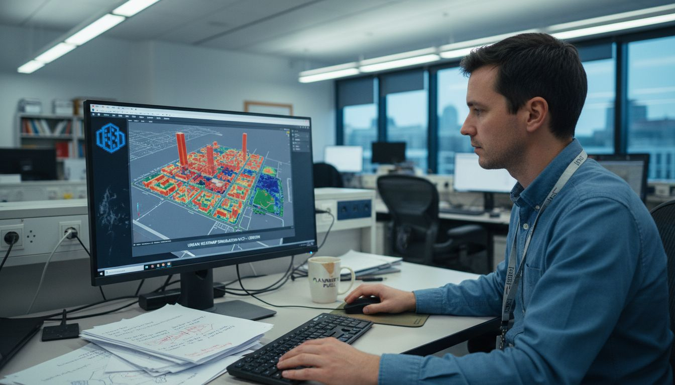
3D technology in sustainable urbanism integrates smart city sensors that feed live data into digital models. Energy consumption drops 15-20% when intelligent systems optimise building operations based on real usage patterns. This integration creates feedback loops where actual performance informs future design decisions.
| Urban zone | Baseline emissions (tonnes CO₂/year) | With 3D-optimised design | Potential reduction |
|---|---|---|---|
| Residential district | 12,500 | 10,000 | 20% |
| Commercial centre | 28,000 | 22,400 | 20% |
| Mixed-use corridor | 18,750 | 15,000 | 20% |
| Industrial park | 45,000 | 36,000 | 20% |
Climate-responsive design benefits through 3D modelling:
- Early identification of microclimate issues before expensive construction commitments
- Quantified comparisons between green infrastructure options like parks versus green roofs
- Solar potential analysis for renewable energy integration at building and district scales
- Air quality modelling showing how street layouts affect pollutant dispersion
- Water management optimisation through topography analysis and permeable surface planning
Pro Tip: Import environmental baseline data into your 3D model during initial concept phases. This immediate visibility of sustainability metrics prevents costly redesigns and ensures climate considerations shape fundamental design choices rather than becoming afterthoughts.
Enhancing stakeholder collaboration with 3D modelling
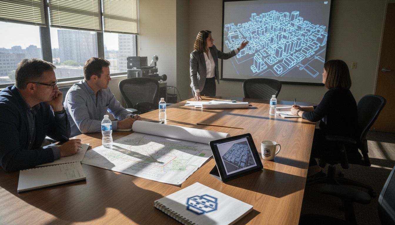
Visualisation technology democratises urban planning by making complex information accessible to everyone, regardless of technical background. 3D visualisation tools can increase stakeholder engagement by up to 60% because emotional resonance drives deeper participation. When residents see their neighbourhood’s future rather than reading descriptions, they form meaningful opinions and contribute valuable local knowledge.
Traditional public consultations often favour articulate, educated participants who understand planning terminology. 3D models level this playing field by communicating through universal visual language. Elderly residents, immigrants with language barriers, and young people all engage equally when exploring interactive digital environments.
Ways 3D models broaden participation:
- Virtual walkthroughs let stakeholders experience proposed developments from street level, understanding scale and character impacts
- Before-after comparisons show exactly how interventions change existing conditions, removing abstraction from decision-making
- Scenario voting tools allow communities to express preferences between design alternatives through simple visual choices
- Accessibility audits enable disabled stakeholders to evaluate wheelchair routes and sensory experiences within proposed designs
- Remote participation options through web platforms include geographically dispersed stakeholders who cannot attend physical meetings
Finnish municipalities implementing 3D urban design collaboration boost strategies report higher-quality feedback and faster consensus building. Stakeholders move beyond vague concerns to specific, constructive suggestions when they clearly understand proposals.
“Interactive 3D visualisation increased meaningful public comments by 60% whilst reducing objections based on misunderstanding by half, demonstrating how clarity builds trust and productive dialogue.”
Usability improvements address previous complexity concerns. Modern interfaces require no technical training, you simply click and drag to explore. Tablet-based consultation stations at libraries and community centres ensure digital divides do not exclude vulnerable populations. This inclusive approach produces legitimate, representative input that strengthens planning decisions.
Simulating urban scenarios for regulatory and zoning compliance
Advanced digital tools combine 3D visualisation with artificial intelligence to evaluate planning proposals against complex regulatory frameworks. Level of Detail 1 (LOD1) models provide sufficient geometric accuracy for comprehensive zoning analysis whilst remaining computationally efficient for large-scale simulations. Digital Twins with 3D modelling enable real-time monitoring and adaptive planning for urban resilience, supporting continuous compliance verification.
Zoning regulations govern building heights, densities, setbacks, and land use mixes. Manually checking compliance across hundreds of parameters creates bottlenecks and errors. Automated 3D analysis instantly identifies violations, calculates allowable development envelopes, and suggests compliant alternatives. This acceleration reduces approval timelines from months to weeks.
Steps to simulate regulatory scenarios:
- Import current zoning ordinances and building codes as rule-based parameters within your 3D platform
- Model baseline existing conditions using cadastral data, building footprints, and height information
- Create alternative development scenarios representing different policy choices like increased density or mixed-use requirements
- Run automated compliance checks highlighting conflicts with setback rules, height limits, or parking requirements
- Generate impact reports quantifying effects on housing capacity, open space ratios, and infrastructure demand
- Iterate designs in real-time during stakeholder workshops, showing immediate compliance feedback for suggested modifications
- Export documentation packages with visual proofs of regulatory adherence for formal approval submissions
Digital Twins extend these capabilities by continuously updating urban data from IoT sensors, building permits, and transport systems. You test policy changes against current conditions rather than outdated baseline information. This adaptive approach identifies emerging issues like traffic congestion or inadequate green space before they become crises.
Real-time benefits transform planning from reactive to proactive. When transport data shows increased congestion, you immediately model new transit routes or road expansions. Energy consumption spikes trigger simulations of efficiency upgrade programmes. This responsive capability builds resilient cities that adapt to changing needs.
Technology infrastructure and standards for 3D modelling
Successful 3D modelling adoption requires standardised frameworks ensuring interoperability between different software platforms and municipal systems. CityGML provides semantic richness by encoding not just geometry but also object relationships, attributes, and hierarchies. CityGML is adopted by more than 30 EU cities, establishing a common language for digital urban environments.
This open standard prevents vendor lock-in that plagues proprietary formats. You export data from one platform and import into another without information loss. Cross-border collaboration becomes feasible when neighbouring municipalities share models in compatible formats. Academic researchers access standardised datasets for comparative studies across European cities.
| Feature | CityGML | Proprietary formats |
|---|---|---|
| Interoperability | Full compatibility across platforms | Limited to specific vendor ecosystems |
| Semantic information | Rich object attributes and relationships | Often geometry-only representations |
| EU adoption | Over 30 cities with growing network | Fragmented, city-specific implementations |
| Long-term viability | Open standard ensures future accessibility | Risk of obsolescence if vendor discontinues support |
| Data exchange | Seamless sharing between municipalities | Requires costly conversion processes |
Data portals and open data frameworks amplify 3D model accessibility. Examples of 3D city models using CityGML in EU cities demonstrate how public repositories let citizens, businesses, and researchers access urban data. This transparency drives innovation as entrepreneurs develop applications using municipal 3D assets.
Cloud infrastructure versus on-premise platforms presents a strategic choice. Cloud solutions offer elastic computing power for complex simulations without capital expenditure on hardware. Small municipalities access enterprise-grade capabilities through subscription models. Automatic updates ensure you always run current software versions. However, data sovereignty concerns require careful vendor selection ensuring EU-based servers and GDPR compliance.
On-premise platforms provide complete data control and customisation but demand internal IT expertise and infrastructure investment. Hybrid approaches combine local data storage with cloud processing power, balancing security with performance.
Pro Tip: Specify CityGML compatibility in procurement requirements when selecting 3D modelling software. This future-proofs investments by ensuring your digital assets remain accessible and exchangeable regardless of future platform changes or vendor relationships.
Common misconceptions about 3D modelling in city planning
Several persistent myths discourage organisations from adopting transformative 3D technologies. Addressing these misconceptions clarifies actual capabilities and constraints, helping you make informed decisions.
Misconception: 3D modelling requires prohibitive budgets and technical expertise beyond public sector capabilities. Reality: Cloud platforms reduce costs by approximately 30% compared to traditional software licensing and hardware infrastructure. Subscription models eliminate large upfront investments, making advanced tools accessible to municipalities of all sizes. User-friendly interfaces require minimal training, with many planners becoming proficient within days.
Misconception: 3D city models serve primarily aesthetic purposes with limited analytical value. Reality: Modern platforms integrate environmental simulations, regulatory compliance checking, and socio-economic impact analysis. You quantify carbon emissions, calculate housing capacity, and model transport demand within the same environment used for visualisation. Benefits of 3D modelling extend far beyond pretty pictures to become comprehensive decision support systems.
Misconception: Complex 3D tools alienate non-technical stakeholders, reducing rather than enhancing public engagement. Reality: Intuitive interfaces and guided exploration features make models more accessible than traditional planning documents. Research consistently shows increased participation and understanding when communities interact with visual representations. Emotional connection to familiar places in digital form drives deeper engagement than abstract maps.
Common myths versus facts:
- Myth: Only large cities benefit from 3D modelling. Fact: Scalable platforms serve towns of all sizes, with simplified implementations for smaller projects.
- Myth: Creating 3D models requires years of data collection. Fact: Automated processes generate baseline models from existing cadastral data within weeks.
- Myth: 3D technology becomes obsolete quickly, wasting investments. Fact: Standards-based approaches ensure longevity, with models remaining useful for decades.
- Myth: Virtual representations cannot capture neighbourhood character. Fact: Photorealistic textures and detailed features accurately convey local identity and heritage.
- Myth: 3D modelling replaces human judgement in planning decisions. Fact: Technology supports rather than supplants professional expertise and democratic deliberation.
Understanding these realities helps overcome institutional resistance rooted in outdated assumptions. The technology has matured significantly, with proven reliability and demonstrated value across diverse planning contexts.
Practical applications and future trends in 3D city planning
Real-world implementations across Europe demonstrate how 3D modelling advances sustainable development goals whilst improving planning efficiency. Rotterdam uses digital twins to model flood resilience, testing different dike heights and drainage configurations before investing in physical infrastructure. Barcelona’s 3D platform simulates solar potential across the entire city, identifying optimal locations for renewable energy installations and prioritising retrofit programmes.
Helsinki integrates transport modelling with 3D urban form analysis, optimising bus routes and cycle infrastructure based on actual movement patterns and proposed developments. This integration reduces planning conflicts and ensures transport investments align with growth strategies.
Emerging technologies enhancing scenario analysis:
- Machine learning algorithms predict development patterns by analysing historical growth trends and current market signals
- Generative design AI proposes optimal building configurations that maximise sustainability metrics within regulatory constraints
- Real-time sensor integration updates Digital Twins continuously, providing current conditions for adaptive management
- Virtual reality walkthroughs enable immersive stakeholder experiences, particularly valuable for heritage conservation and public space design
- Automated impact assessments calculate traffic generation, school demand, and utility loads instantly for proposed developments
Digital Twins represent the frontier of urban management, moving beyond static planning to continuous operational oversight. Sensors monitoring air quality, traffic flow, energy use, and waste generation feed live data into 3D models. You identify service delivery gaps immediately and test interventions digitally before implementation. This responsive capability transforms city governance from periodic master planning to ongoing optimisation.
Collaboration improvements accelerate approval processes significantly. When all stakeholders view the same 3D model, misunderstandings decrease and consensus emerges faster. Developers receive clearer guidance about acceptable proposals. Regulators verify compliance efficiently. Communities see their input incorporated visually, building trust in planning processes.
Looking toward future city planning in 2026, integration between 3D modelling and emerging technologies like blockchain for transparent land transactions and quantum computing for complex optimisation problems will expand capabilities further. The trajectory points toward increasingly intelligent, adaptive urban environments where data-driven insights support better decisions.
More examples of 3D urban design boosting collaboration across European cities demonstrate proven implementation strategies you can adapt to local contexts.
Conclusion: bridging technology and urban vision
3D modelling fundamentally transforms how we plan, communicate, and implement urban development across the EU. This technology supports sustainability through precise environmental analysis, enhances democracy through inclusive stakeholder engagement, and ensures compliance through automated regulatory checking. Standards like CityGML and affordable cloud platforms democratise access, making sophisticated capabilities available to municipalities of all sizes.
Future-proofing requires adopting scalable, interoperable solutions that evolve with technological advances. The integration of AI, Digital Twins, and real-time data creates adaptive planning systems that respond to changing urban conditions. Rather than static master plans, modern approaches enable continuous learning and improvement.
You can begin this transformation immediately by piloting 3D modelling on a single project, measuring engagement improvements and efficiency gains. Invest in training that builds internal capacity whilst partnering with experienced consultants for complex implementations. The evidence clearly demonstrates that early adopters gain competitive advantages in delivering better outcomes faster. Embrace these tools now to shape resilient, sustainable, liveable cities for future generations.
Discover powerful 3D city planning tools
Transforming urban planning concepts into actionable reality requires robust platforms that integrate visualisation, analysis, and collaboration seamlessly. 3D Cityplanner delivers comprehensive solutions purpose-built for EU urban professionals navigating complex regulatory environments whilst engaging diverse stakeholders. The platform combines advanced 3D modelling with Digital Twin capabilities, supporting everything from initial concept visualisation through detailed compliance verification and ongoing urban management.
Discover specialised city planning tools that automate zoning analysis, environmental simulations, and stakeholder consultation workflows. Leverage digital twin technology to monitor urban performance continuously and test interventions before implementation. Explore how tailored solutions address your specific challenges in creating sustainable, inclusive, efficient cities across Europe.
Frequently asked questions
What are the main benefits of 3D modelling in city planning?
3D modelling enhances visualisation clarity, making complex urban designs accessible to non-technical stakeholders and increasing engagement by up to 60%. It integrates environmental simulations for sustainability analysis, automates regulatory compliance checking to accelerate approvals, and supports real-time scenario testing that improves decision quality. These capabilities reduce planning conflicts, build stakeholder trust, and deliver better urban outcomes efficiently.
How does 3D modelling improve public engagement in planning projects?
Interactive 3D visualisations communicate proposals through universal visual language that transcends technical expertise and language barriers. Stakeholders explore virtual environments from multiple perspectives, forming emotional connections to familiar places that drive meaningful participation. This accessibility produces higher-quality feedback from diverse demographics, reduces objections based on misunderstanding, and builds legitimate consensus faster than traditional consultation methods.
What standards should be followed for EU 3D city modelling?
CityGML represents the primary open standard, adopted by over 30 EU cities for its semantic richness and interoperability. This framework encodes not just geometry but object relationships, attributes, and hierarchies, enabling seamless data exchange between platforms and municipalities. Following CityGML ensures future-proof investments, facilitates cross-border collaboration, and provides access to growing networks of compatible tools and datasets across Europe.
Can 3D modelling tools integrate real-time data for adaptive planning?
Digital Twins combine 3D models with live sensor feeds from IoT devices monitoring traffic, energy use, air quality, and infrastructure performance. This continuous data integration enables responsive urban management where you test interventions against current conditions rather than outdated baselines. Real-time capabilities identify emerging issues immediately and support adaptive strategies that maintain urban resilience as conditions change.
Is adopting 3D modelling cost-effective for public sector urban planning?
Cloud-based platforms reduce adoption costs by approximately 30% compared to traditional software licensing and hardware infrastructure through subscription models that eliminate large upfront investments. The efficiency gains from automated compliance checking, reduced planning conflicts, and faster approvals deliver measurable returns. Small municipalities access enterprise capabilities affordably, whilst improved decision quality prevents costly design errors that far exceed technology investments.


