3D Urban Planning Europe: 60% Stakeholder Engagement Boost

European cities produce 70% of EU emissions while occupying just 5% of land. This striking imbalance demands urgent transformation in how we design and develop urban spaces. Integrating advanced 3D urban planning technologies with sustainability principles offers European planners and architects a proven pathway to reduce environmental impact, enhance stakeholder collaboration, and future-proof city development against climate challenges.
Table of Contents
- Introduction To 3D Urban Planning And Sustainability
- Technological Innovations Driving 3D Urban Planning
- Integrating Sustainability Principles Into 3D Urban Planning
- Enhancing Stakeholder Engagement Through 3D Visualization
- Challenges, Misconceptions, And Barriers In 3D Urban Planning
- European Policy And Funding Landscape Supporting 3D Sustainable Urban Planning
- Practical Applications And Future Trends In 3D Urban Planning
- Conclusion And Strategic Recommendations For Urban Planners
- Discover Advanced 3D Urban Planning Solutions
Key Takeaways
| Point | Details |
|---|---|
| Engagement Impact | 3D visualization tools increase community stakeholder engagement by up to 60% in urban projects. |
| Digital Twin Scale | Over 14 EU countries collaborate on digital twin solutions targeting 100 cities by 2026. |
| Funding Commitment | EU’s Horizon Europe allocates over €1 billion to smart city and 3D planning initiatives. |
| Energy Efficiency | Smart city technologies integrated with 3D models reduce district energy use by 15-20%. |
| Cost Misconception | Cloud-based 3D platforms have seen 30% cost reductions, dispelling adoption barriers. |
Introduction to 3D Urban Planning and Sustainability
3D urban planning transforms traditional two-dimensional blueprints into dynamic, interactive spatial models that planners and architects can manipulate in real time. These digital representations allow professionals to visualize building heights, shadow impacts, infrastructure networks, and public space configurations before construction begins. The technology goes beyond aesthetic rendering to incorporate environmental data, traffic patterns, and resource consumption metrics.
Sustainability in European urban contexts encompasses three critical dimensions: environmental stewardship, social equity, and economic viability. Climate resilience has become non-negotiable as cities face increasing heat waves, flooding risks, and air quality challenges. Social equity ensures that urban development benefits all community members, not just privileged groups. Economic viability means creating urban systems that generate long-term value without depleting natural capital.
The environmental footprint of cities justifies urgent action. Cities produce 70% of EU emissions but occupy only 5% of land, emphasizing the need for sustainable urban design. This concentration creates both a challenge and an opportunity: small spatial interventions can yield disproportionately large environmental benefits when guided by accurate 3D modeling and sustainability frameworks.
Key foundations include:
- Spatial accuracy enabling precise solar access, wind flow, and thermal comfort analysis
- Multi-layered data integration combining building information, green infrastructure, and mobility networks
- Scenario modeling capabilities allowing planners to test policy interventions before implementation
- Stakeholder visualization tools making complex planning decisions accessible to non-technical audiences
Technological Innovations Driving 3D Urban Planning
3D visualization technology has evolved from static renderings to interactive environments where planners manipulate urban elements and instantly observe consequences. Modern platforms enable spatial and environmental analysis simultaneously, calculating shadow patterns, view corridors, pedestrian accessibility, and microclimate effects as designs change. This real-time feedback transforms planning from guesswork into evidence-based decision making.
Digital twin technology represents the frontier of urban planning innovation, combining historical data, real-time sensor feeds, and predictive modeling in unified virtual environments. These digital replicas mirror physical cities with remarkable fidelity, updating continuously as conditions change. Planners can test traffic rerouting, green infrastructure placement, or emergency response protocols within the digital twin before deploying solutions in the real world. Over 14 EU countries are collaborating to bring digital twin solutions to 100 cities by 2026 with investments exceeding €80 million.
Artificial intelligence enhances 3D planning platforms by analyzing vast datasets to identify patterns humans might miss. AI tools predict how proposed developments will affect traffic congestion, housing affordability, or carbon emissions decades into the future. Machine learning algorithms optimize building placement for energy efficiency, suggest green corridor locations based on biodiversity data, and forecast demographic shifts requiring infrastructure adjustments.
Core technological capabilities include:
- Cloud-based collaboration platforms enabling distributed teams to work on shared 3D models simultaneously
- Automated building generation from cadastral data, reducing manual modeling time by 80%
- Real-time environmental simulation calculating noise propagation, air quality dispersion, and solar potential
- 4D timeline visualization showing project phases and long-term urban evolution
- Cross-platform data import supporting GIS, BIM, CAD, and sensor network integration
Pro Tip: Start with a focused pilot project using 3D tools on one district rather than attempting city-wide implementation immediately. This approach builds institutional capacity and demonstrates value before scaling.
Integrating Sustainability Principles into 3D Urban Planning
European cities face mounting pressure to decarbonize while improving livability. Smart city initiatives have contributed to reducing energy use by 15-20% in targeted districts through intelligent resource management and behavioral nudges. When combined with 3D planning tools, these gains multiply as spatial optimization reduces heating demands, maximizes natural lighting, and positions renewable energy infrastructure optimally.
Sustainability in 3D urban planning embeds environmental considerations into every design decision. Planners analyze building orientation to minimize cooling loads, design street networks that encourage walking and cycling, and integrate green infrastructure that manages stormwater while reducing urban heat islands. The 3D environment makes these trade-offs visible, allowing stakeholders to balance competing priorities with transparency.
Climate resilience requires cities to withstand extreme weather events without catastrophic failures. 3D models simulate flood scenarios under different rainfall intensities, revealing vulnerable infrastructure and evacuation bottlenecks. Planners test nature-based solutions like permeable pavements and bioswales within the digital environment, optimizing placement for maximum protective effect. Heat vulnerability mapping identifies neighborhoods requiring urgent greening interventions.
Core sustainable planning principles include:
- Compact urban form reducing sprawl and preserving agricultural land outside city boundaries
- Mixed-use development minimizing transportation needs by co-locating housing, employment, and services
- Green-blue infrastructure integration managing water, cooling cities, and supporting biodiversity
- Circular economy principles designing buildings and infrastructure for adaptability and material reuse
- Social mixing preventing segregated neighborhoods and ensuring equitable access to amenities
Enhancing Stakeholder Engagement Through 3D Visualization
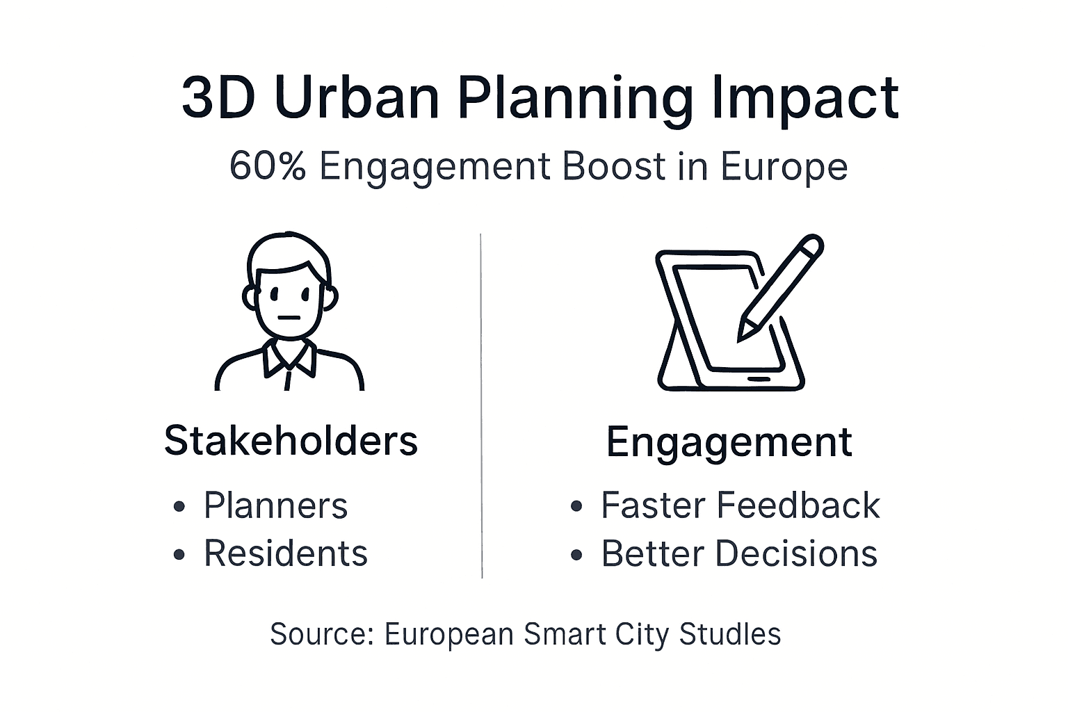
Traditional planning processes often exclude community voices due to technical complexity and inaccessible documentation. 3D visualization democratizes participation by presenting proposals in intuitive formats anyone can understand. Metrics show 60% increase in community engagement using 3D tools, as residents connect emotionally with virtual representations of their future neighborhoods far more readily than with technical drawings.
3D visualization transforms public consultations from passive presentations into interactive design sessions. Residents walk through proposed developments using virtual reality, experiencing scale, lighting, and spatial relationships firsthand. They provide feedback on building heights, open space allocation, and aesthetic treatments while viewing changes in real time. This iterative dialogue produces designs reflecting genuine community priorities rather than planner assumptions.
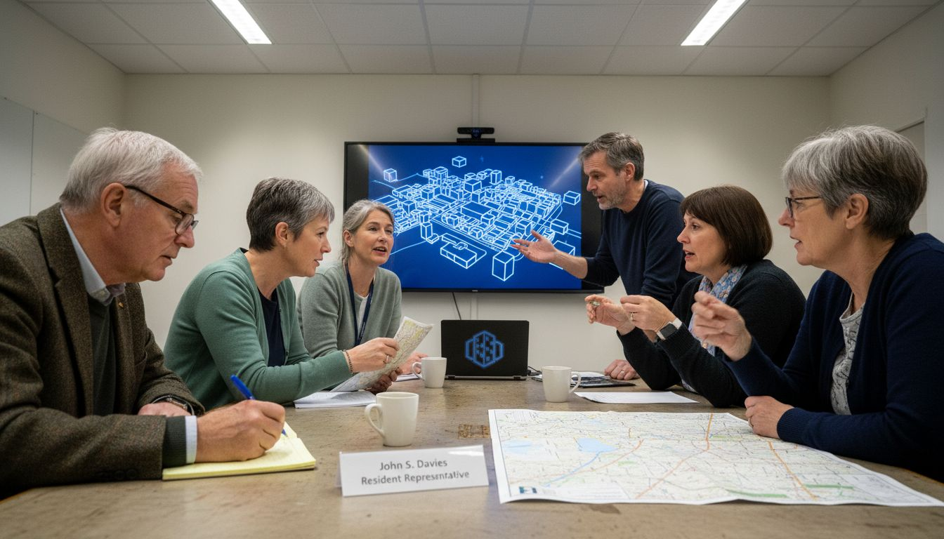
Collaborative digital platforms balance power dynamics by giving all stakeholders simultaneous access to planning information and modeling tools. Developers, municipal authorities, residents, and environmental advocates work within shared 3D environments, making trade-offs transparent. Conflict resolution improves when parties visualize exactly what they’re negotiating, reducing misunderstandings that derail projects.
Engagement benefits include:
- Accelerated approval processes as stakeholders align earlier in project timelines
- Higher quality feedback focused on substantive design elements rather than confusion about proposals
- Increased public trust through transparency and visible responsiveness to community input
- Reduced opposition and litigation as concerns are addressed proactively through collaborative design
- Documentation of decision rationales preserving institutional knowledge for future projects
Pro Tip: Provide multiple visualization formats including web-based 3D viewers, printed renderings, and VR experiences to accommodate different stakeholder preferences and technical access levels.
Challenges, Misconceptions, and Barriers in 3D Urban Planning
Many planners believe 3D urban planning platforms require prohibitive investments in software licenses, hardware, and training. Recent market evolution contradicts this assumption. Cloud-based platforms have seen 30% cost reductions over the past three years, eliminating expensive local infrastructure requirements. Subscription pricing models spread costs across fiscal years, making budgeting manageable for municipalities of all sizes.
Another misconception suggests 3D tools slow planning processes by adding complexity. Evidence shows the opposite: comprehensive 3D analysis early in project development identifies conflicts and opportunities that would otherwise emerge during expensive construction phases. Stakeholder alignment improves when everyone visualizes the same proposal, reducing revision cycles. Projects using 3D planning typically receive approvals 25-40% faster than traditional approaches.
Data integration challenges remain genuine barriers. European cities maintain information across fragmented systems using incompatible formats and coordinate systems. Consolidating cadastral records, utility networks, environmental sensors, and demographic data into unified 3D models requires significant data cleaning and standardization. GIS data integration tools have improved substantially, yet interoperability between municipal departments and external partners remains inconsistent.
Common resistance points and solutions:
- Workflow disruption concerns: Implement 3D tools alongside existing processes initially, gradually shifting responsibilities as confidence builds.
- Skills gap anxiety: Invest in targeted training programs and hire digital natives to mentor traditional planners.
- Institutional inertia: Demonstrate quick wins through pilot projects that build political support for broader adoption.
- Vendor lock-in fears: Prioritize platforms supporting open data standards and export flexibility.
- Privacy and security concerns: Establish clear data governance protocols before deploying shared 3D environments.
| Aspect | Traditional 2D Planning | 3D Planning |
|---|---|---|
| Visualization | Flat maps and elevations | Interactive spatial models |
| Stakeholder understanding | Requires technical expertise | Intuitive for general public |
| Environmental analysis | Separate manual calculations | Integrated real-time simulation |
| Collaboration | Sequential review processes | Concurrent multi-party access |
| Decision speed | Slower due to information gaps | Faster through shared context |
| Upfront cost | Lower software investment | Higher initial technology cost |
| Long-term efficiency | More revisions and delays | Fewer costly late-stage changes |
European Policy and Funding Landscape Supporting 3D Sustainable Urban Planning
Horizon Europe funding has allocated over €1 billion towards smart city development projects integrating digital urban planning tools. This massive investment signals institutional commitment to technology-enabled urban transformation across the continent. Grant programs prioritize projects demonstrating scalability, cross-border collaboration, and measurable sustainability outcomes.
The Citiverse consortium exemplifies multi-national collaboration advancing digital twin technology for urban applications. By pooling resources and expertise, participating countries accelerate innovation while avoiding duplicative development efforts. Shared technical standards emerging from these partnerships ensure interoperability, allowing cities to exchange data and best practices seamlessly.
EU policy mandates increasingly require sustainability considerations in urban development decisions. The European Green Deal establishes ambitious climate neutrality targets that cities cannot meet using conventional planning approaches. Member states translate these commitments into national regulations requiring environmental impact assessments, carbon accounting, and climate adaptation strategies for major projects. 3D planning tools provide the analytical foundation for compliance.
Opportunities for urban planners:
- Competitive grant applications for digital infrastructure modernization projects
- Cross-border knowledge exchange programs sharing implementation experiences
- Technical assistance accessing EU-funded expert advisory services
- Pilot project participation testing emerging technologies with financial support
- Professional development funding for skills training in digital urban planning tools
Practical Applications and Future Trends in 3D Urban Planning
Several European cities demonstrate tangible benefits from 3D sustainable urban planning implementation. Helsinki’s 3D model covers the entire municipality, enabling developers to test proposals against zoning regulations automatically before submitting formal applications. This streamlined approval process reduced permitting timelines by 35% while maintaining planning quality. Amsterdam’s digital twin integrates real-time energy consumption data, allowing policymakers to target efficiency interventions where they’ll achieve maximum impact.
Digital twin case studies reveal common success patterns. Cities achieving best results establish clear governance structures defining data ownership, access rights, and update responsibilities before technical implementation. They prioritize user training equally with software procurement, recognizing that technology alone doesn’t transform outcomes. Successful implementations also maintain strong connections between digital models and operational management systems, ensuring virtual representations remain synchronized with physical reality.
Emerging collaboration platforms enhance real-time multi-stakeholder design capabilities. Next-generation tools will incorporate augmented reality overlays allowing planners to visualize proposals on-site using mobile devices. Blockchain integration will create immutable records of planning decisions and stakeholder commitments, improving accountability. Quantum computing applications will enable scenario modeling at unprecedented scales, testing thousands of urban configuration permutations to identify optimal solutions.
| Platform Feature | Current Generation | Emerging Capabilities |
|---|---|---|
| Data sources | Static imports | Live sensor feeds |
| Collaboration | Asynchronous review | Synchronous co-design |
| Analysis scope | District-level | Metropolitan-regional |
| Scenario testing | Dozens of variants | Thousands via AI optimization |
| Accessibility | Desktop software | Mobile and AR interfaces |
Anticipated developments by 2030:
- Predictive modeling accuracy improving 40% through machine learning refinement
- Automated compliance checking reducing manual regulatory review time by 60%
- Collaborative planning platforms integrating natural language interfaces for non-technical stakeholder participation
- Real-time carbon accounting displaying emissions impacts of design decisions instantly
- Standardized digital twin frameworks enabling seamless data exchange between European cities
Conclusion and Strategic Recommendations for Urban Planners
Integrating 3D technology with sustainability principles transforms urban planning from reactive problem-solving into proactive systems design. European planners adopting these tools gain competitive advantages in project delivery speed, stakeholder satisfaction, and environmental performance. The technology enables evidence-based decisions replacing intuition and political compromise with objective analysis.
Overcoming adoption barriers requires strategic approaches. Build internal champions by training motivated staff who can demonstrate value to skeptical colleagues. Start with manageable pilot projects delivering quick wins that justify expanded investment. Address data integration systematically, prioritizing high-value datasets before attempting comprehensive coverage. Partner with universities and research institutions accessing cutting-edge capabilities beyond municipal budgets.
Leverage EU funding opportunities aggressively. Horizon Europe and national grant programs provide substantial financial support for digital planning infrastructure and skills development. Collaborate with neighboring municipalities to share costs and learning curves. Join cross-border networks exchanging implementation experiences and technical solutions.
Actionable next steps:
- Audit current planning workflows identifying bottlenecks 3D tools could eliminate
- Evaluate platform options prioritizing interoperability and user-friendliness over feature maximization
- Develop phased implementation roadmaps with clear milestones and success metrics
- Invest in continuous professional development ensuring teams maintain technical proficiency
- Establish data governance frameworks before deploying shared digital environments
Discover Advanced 3D Urban Planning Solutions
Transforming your urban planning approach requires platforms built specifically for European regulatory contexts and sustainability priorities. 3D Cityplanner delivers comprehensive urban planner tools supporting every phase from initial concept through construction and ongoing management.
Our platform combines automatic building generation, environmental simulation, and real-time stakeholder collaboration in an intuitive interface requiring minimal training. Import existing GIS data, test design alternatives, and generate compliance documentation within unified workflows. Features include 4D timeline visualization, noise propagation modeling, sightline analysis, and solar potential mapping.
Try a demo experiencing how 3D Cityplanner accelerates project delivery while improving sustainability outcomes. Explore our complete feature list discovering capabilities tailored for European urban development challenges. Register for personalized demonstrations showing exactly how our platform addresses your specific planning needs.
Frequently Asked Questions
What initial investment do municipalities need for 3D urban planning adoption?
Cloud-based platforms typically cost €5,000-€15,000 annually per user depending on feature requirements, with no hardware infrastructure investment needed. Budget an additional 20-30% for initial training and data preparation. Many municipalities offset costs through EU grant programs.
How do digital twins differ from standard 3D city models?
Digital twins integrate real-time data from sensors and operational systems, continuously updating to reflect current conditions. Standard 3D models remain static representations built at specific points in time. This dynamic capability enables predictive analysis and operational management impossible with traditional models.
Can small municipalities benefit from 3D planning or is it only viable for large cities?
Small municipalities often achieve proportionally greater benefits because 3D tools compensate for limited staff resources. Automated analysis replaces manual calculations, and improved stakeholder communication reduces time-consuming public opposition. Regional consortia allow cost sharing among smaller jurisdictions.
What data quality standards must municipalities meet before implementing 3D planning platforms?
Platforms function with imperfect data, though accuracy improves outcomes. Prioritize high-quality building footprints, terrain elevation, and street networks initially. Environmental sensor data, demographic statistics, and detailed building attributes can be added incrementally as availability improves.
How long does typical implementation take from procurement to operational use?
Basic implementation establishing 3D city models and training initial users typically requires 3-6 months. Achieving advanced capabilities like real-time digital twins with integrated sensor networks may take 12-24 months depending on existing data infrastructure and organizational change management effectiveness.
Do 3D planning tools replace traditional planning expertise or complement it?
They complement and enhance professional judgment rather than replacing it. Planners gain analytical capabilities impossible manually, but interpreting results and making balanced decisions considering non-quantifiable factors still requires human expertise. The technology amplifies planner effectiveness rather than substituting for experience.
Recommended
- Collaborative Urban Planning: Advancing Sustainable Cities – 3D Urban Development
- Role of 3D Technology in Urbanism: Shaping Sustainable Cities – 3D Urban Development
- Why Use 3D Modelling in Urban Design Projects – 3D Urban Development
- 6 Top Urban Design Strategies for Modern Planners – 3D Urban Development


