3D environments for future-ready architecture in 2026

TL;DR:3D environments now serve as essential tools for design accuracy, sustainability, and stakeholder collaboration.Immersive platforms like VR, AR, and digital twins are used at different project phases for analysis and public engagement.High-quality data input and disciplined workflows are critical for realizing the true value and ROI of 3D environments.
Three-dimensional environments were once considered a finishing touch, a polished visual to impress clients before a project broke ground. That perception is now fundamentally outdated. As critical 3D infrastructure for design accuracy, sustainability analysis, and stakeholder coordination, these environments now underpin the entire architectural workflow from concept through to completion. For urban planners, architects, and developers, understanding their full capabilities is no longer a competitive advantage. It is a baseline requirement. This article clarifies what 3D environments actually encompass, the workflows powering them, and how to integrate them effectively into your own projects.
Table of Contents
- Understanding 3D environments in modern architecture
- Workflows and technology: from BIM to digital twins
- Comparing immersive 3D platforms: VR, AR, and analytical models
- Practical integration: from pilot to city-scale implementation
- What most guides miss about 3D’s real-world impact
- Explore advanced 3D city planning with 3D Cityplanner
- Frequently asked questions
Key Takeaways
| Point | Details |
|---|---|
| More than visualisation | 3D environments deliver robust analytical and co-design capabilities far beyond simple visualisation. |
| BIM and CityGML synergy | Hybrid workflows combining BIM and CityGML unlock city-scale, data-rich 3D models. |
| Choose the right platform | Select between VR, AR, and analytical models based on project goals, stakeholder needs, and workflow integration. |
| Empirical validation matters | Input BIM quality and rigorous validation are essential for accurate, scalable 3D integration. |
| Proven ROI in practice | 3D systems reduce design conflicts, improve sustainability, and drive savings throughout the project lifecycle. |
Understanding 3D environments in modern architecture
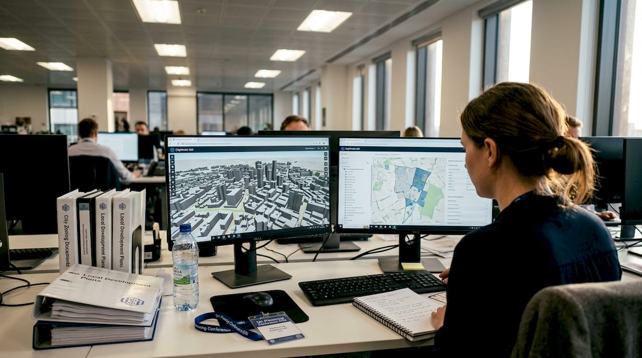
The term “3D environment” covers a broader spectrum than most professionals initially assume. At its core, it includes static three-dimensional models used for design validation, but it also extends to virtual reality (VR) experiences, augmented reality (AR) overlays, and digital twins. Each of these represents a different level of interactivity, data richness, and analytical capability.
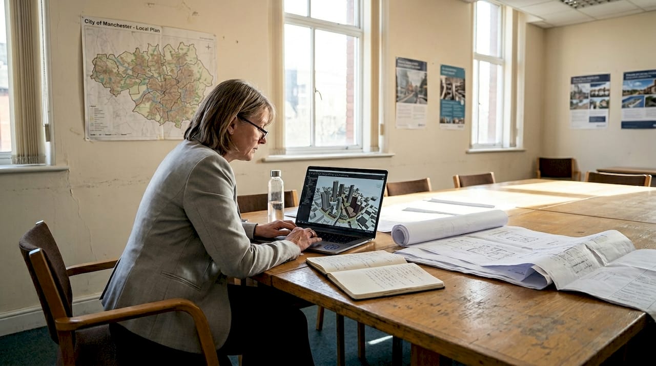
A 3D model is a geometric representation of a building or urban area, typically built in tools like Revit, SketchUp, or ArchiCAD. VR places users inside a fully immersive, computer-generated environment. AR overlays digital content onto the physical world, useful for on-site visualisation. Digital twins are the most sophisticated tier: living simulation environments that mirror real-world assets in real time, integrating sensor data, performance metrics, and lifecycle information.
Historically, 3D tools served a narrow purpose. Architects used them to generate renders for client presentations. The shift began when BIM (Building Information Modelling) introduced data-rich models that could carry structural, mechanical, and cost information. From there, the integration of GIS data, IoT sensors, and cloud computing transformed isolated models into connected planning infrastructure.
Today, these environments support a wide range of functions:
- Early-stage conflict detection between structural and MEP systems
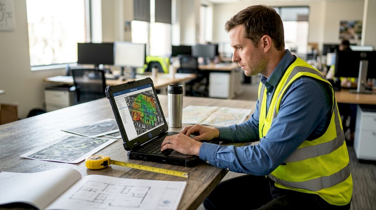
- Sustainability modelling including solar gain, wind flow, and energy performance
- Acoustic simulation and sightline analysis for urban contexts
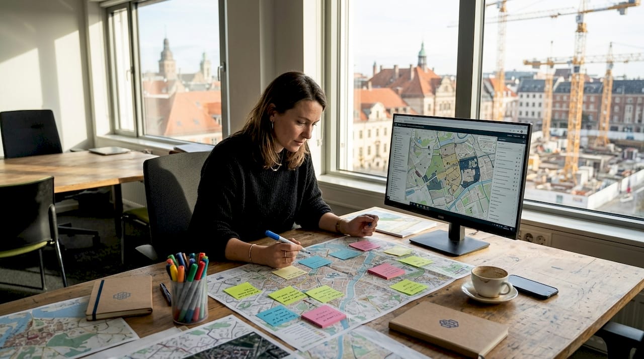
- Participatory design sessions with non-technical stakeholders
- Real-time performance monitoring via digital twin platforms
As one body of research confirms, 3D environments now underlie not only visualisation but also analysis, coordination, and performance-driven urban design. This shift connects directly to broader trends in smart city development, where digital twin advances are reshaping how cities are planned, monitored, and maintained.
“3D environments have matured from visual aids into the connective tissue of modern architectural and urban planning practice.”
Workflows and technology: from BIM to digital twins
Understanding which tools to use and when requires clarity on how different systems interact. Three primary frameworks dominate large-scale 3D workflows: BIM, CityGML, and hybrid pipelines that combine both.
BIM is best suited to individual buildings or small clusters, providing detailed parametric data at the component level. CityGML operates at urban scale, structuring city-wide geometry and semantic data into standardised Levels of Detail (LoDs). Hybrid workflows bridge these two, enabling planners to connect building-level BIM data with city-scale CityGML models for integrated analysis.
Automated data generation via LiDAR (Light Detection and Ranging) and photogrammetry has dramatically accelerated model creation. These techniques capture real-world geometry at scale, populating city models with accurate building footprints, terrain data, and infrastructure elements. However, hybrid BIM-CityGML workflows and automated generation require empirical validation and rigorous input quality control.
| Approach | Scale | Key strength | Primary risk |
|---|---|---|---|
| BIM | Building level | Parametric detail | Limited urban context |
| CityGML | City scale | Semantic enrichment | Data conversion loss |
| LiDAR/photogrammetry | Any scale | Speed and coverage | Error propagation |
| Hybrid pipeline | Multi-scale | Integrated analysis | Complexity and cost |
Data standards play a crucial role here. Semantic enrichment, Application Domain Extensions (ADEs), and LoD specifications determine how much analytical value a model can deliver. A model at LoD1 provides massing only; LoD3 includes facade detail and openings. Choosing the right LoD for your project phase avoids unnecessary processing overhead.
One critical and often underestimated risk: BIM quality directly impacts 3D output quality. Volumetric abstractions are error-prone, and data integration across systems is non-trivial. Poor input data cascades into inaccurate simulations and flawed decisions downstream.
Pro Tip: Before automating model generation, audit your source BIM data for geometric consistency, naming conventions, and completeness. Fixing errors at source costs far less than correcting a city-scale model after the fact.
For practical guidance on building these models from the ground up, the process of creating city 3D models is well worth exploring, alongside a review of advanced modelling tools available in 2026.
Comparing immersive 3D platforms: VR, AR, and analytical models
With the technological foundations clear, the next question is which immersive platform best serves your project phase and stakeholder group. Each option carries distinct strengths, limitations, and ideal use cases.
Virtual reality (VR) delivers full immersion. Users are placed entirely inside a rendered environment, making it powerful for design review, walkthroughs, and public consultation. Research confirms that VR boosts participation from non-professional stakeholders in residential co-design, outperforming both 2D drawings and standard BIM interfaces. However, VR isolates users from their physical environment, which limits collaborative on-site work.
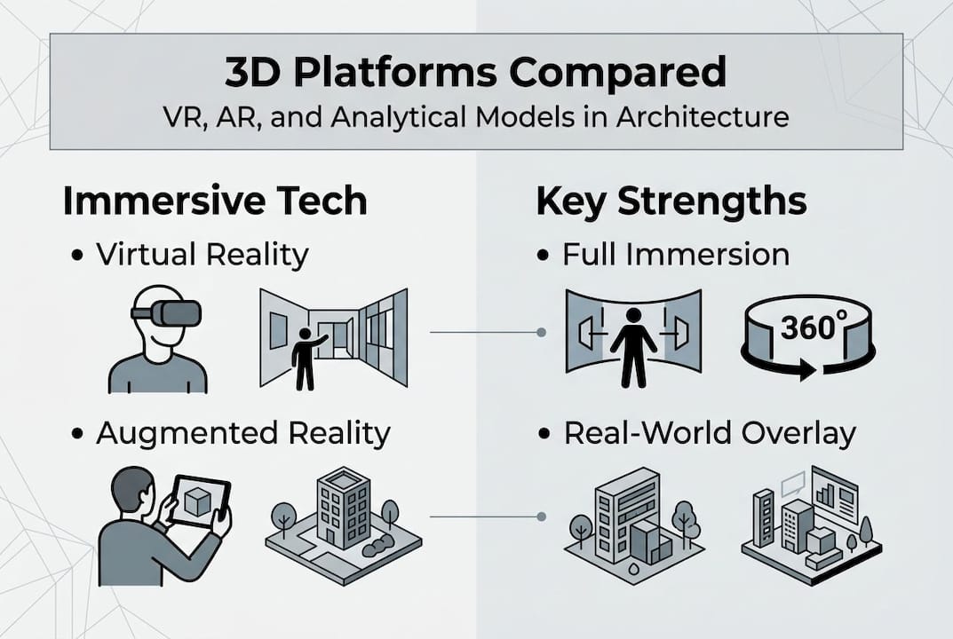
Augmented reality (AR) and mixed reality (MR) overlay digital content onto the real world. This makes them particularly effective for site visits, where planners can visualise proposed structures in their actual context. The trade-off is that VR excels at full immersion while AR and MR foster collaborative real-world design work, though with field-of-view constraints and ergonomic limitations.
Analytical 3D models sit outside the immersive spectrum but deliver the highest data density. These environments support solar analysis, traffic simulation, noise modelling, and infrastructure stress-testing. They are the workhorses of urban planning workflows.
Here is a practical selection guide based on project phase:
- Concept and feasibility: Use analytical models to test massing, solar access, and infrastructure capacity early.
- Design development: Introduce VR for internal design reviews and client walkthroughs.
- Public consultation: Deploy VR or AR to engage non-technical stakeholders meaningfully.
- Construction and site management: AR overlays support on-site coordination and clash resolution.
- Operations and maintenance: Digital twins provide ongoing performance monitoring.
For a structured comparison of available platforms and their capabilities, the 3D platform guide offers detailed, practical coverage. Further VR/AR workflow nuances are worth reviewing before committing to a platform for large-scale projects.
Practical integration: from pilot to city-scale implementation
Knowing which tools to use is only half the challenge. Scaling 3D environments from a single pilot project to city-wide adoption requires a structured approach, clear stakeholder alignment, and measurable benchmarks.
Start small and validate. A focused pilot on a single development block or district allows your team to test data pipelines, identify integration gaps, and build internal confidence before scaling. Key steps in a successful rollout include:
- Define objectives first: Establish what the 3D environment must deliver, whether that is conflict detection, public engagement, or lifecycle cost modelling.
- Audit existing data: Identify available GIS layers, BIM files, and survey data before selecting tools.
- Establish data governance: Agree on naming standards, LoD requirements, and update protocols across all teams.
- Run a structured pilot: Test the full workflow on a contained project and document performance against defined metrics.
- Scale with lessons learned: Apply validated workflows to broader city areas, expanding data integration incrementally.
Stakeholder buy-in is often the hardest part. 3D metrics outperform 2D in predicting public perceptions and driving better planning decisions, which makes the case for investment easier. Present this evidence to decision-makers early.
The ROI case is strong. Early conflict detection and sustainability analysis are concrete financial benefits, reducing costly rework and enabling better lifecycle decisions before construction begins.
Pro Tip: Assign a dedicated data manager to your 3D environment from day one. Models degrade in value when they fall out of sync with design changes. A single point of responsibility keeps the model current and trustworthy.
For those working on regeneration schemes, understanding how 3D twins support redevelopment is particularly relevant. Broader guidance on smarter city planning through 3D modelling also offers a useful strategic frame. Additional digital twin insights from recent research reinforce the scalability case.
What most guides miss about 3D’s real-world impact
Most discussions of 3D environments focus on capability lists and technology comparisons. What they rarely address is where value actually comes from in practice, and where it quietly disappears.
The honest answer is that ROI from 3D does not come from the technology itself. It comes from conflict reduction, lifecycle savings, and decisions made earlier with better information. Flashy renders and immersive walkthroughs are useful, but they are not the source of financial return.
The most overlooked risk is input quality. Research is clear: prioritising BIM quality and empirical validation is essential; the latest trend will not save a project built on poor source data. Volumetric errors in BIM propagate through every downstream model and simulation.
Hybrid workflows, combining automated generation with manual expert review, consistently outperform fully automated pipelines in real-world conditions. Human judgement remains essential for interpreting edge cases, validating outputs, and maintaining model integrity over time. The model creation best practices that deliver sustained value are rarely glamorous. They are disciplined, iterative, and grounded in data rigour.
Explore advanced 3D city planning with 3D Cityplanner
For urban planners and architects ready to move beyond theory, the right platform makes all the difference. Robust 3D integration requires tools that handle everything from automated building generation and sightline analysis to noise simulation and 4D timeline planning.
3D Cityplanner is built specifically for professionals working at the intersection of architecture, urban development, and real estate. Whether you are assessing the future of urban development or need a reliable city planning tool that supports collaborative decision-making across stakeholders, the platform offers a trial period with no upfront payment. Explore what city-scale 3D can do for your next project.
Frequently asked questions
How do 3D environments improve architectural design accuracy?
3D environments underpin design accuracy by enabling data-rich simulation and early conflict detection, which reduces errors before construction begins. They also improve coordination across disciplines, ensuring structural, mechanical, and spatial elements align throughout the design process.
What are the key challenges when implementing VR or AR in architecture?
Major barriers include high initial costs, the technical skills required to operate and maintain systems, and the risk of cybersickness during extended VR sessions. VR/AR limitations also include cognitive overload and data conversion losses when moving between platforms.
When should I use BIM, CityGML, or digital twins?
Use BIM for detailed building-level modelling, CityGML when working at city scale with standardised semantic data, and digital twins when real-time performance integration and lifecycle management are required. The choice depends on project scale and the analytical depth needed.
Does using 3D environments save money in urban development projects?
Yes. 3D integration reduces rework through early conflict detection and enables sustainability and lifecycle cost analysis before commitments are made. These benefits consistently deliver measurable ROI across both small and large-scale development projects.
Recommended
- The role of 3D visualisation for architects in 2026 – 3D Urban Development
- The role of 3D models in architecture and urban planning – 3D Urban Development
- Urban project optimisation with advanced 3D tools in 2026 – 3D Urban Development
- Future of City Planning 2026: Shaping Sustainable Urban Spaces – 3D Urban Development